more stats
3,894 ft
Distance
-608 ft
Descent
00:22:07
Avg time
-609 ft
Altitude change
3,312 ft
Altitude min
3,921 ft
Altitude max
3,921 ft
Altitude start
3,314 ft
Altitude end
-15.6%
Grade
-49.9%
Grade max
-1.5%
Grade min
33 ft
Distance climb
3,819 ft
Distance down
23 ft
Distance flat
00:22:07
Avg time

Da Ansa Details

  • Activities
    • Mountain Bike
    • E-Bike
  • Riding Area
  • Ref Number
    #1
  • Difficulty Rating
  • Local Popularity
    75 in Mountain Biking [+]
    • 75 in E-Biking
  • Global Ranking
    #7914 in Mountain Biking [+]
    • #48168 in E-Biking
  • Trail Type
    Singletrack
  • Bike Type
    DH, AM
  • Direction
    Downhill Only
    Popular Direction Shown
  • Trail Visibility
    Always easy to follow
  • eBike Allowed
    Yes up to Class 1

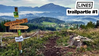
First trail at Josiberg Trails. Longest one, starts from top and ends close to the parking spot.

Recent Activity on Trail

Past Week
  • 1 rides
  • 8 miles average
6 Months
  • 4 rides
  • 8 miles avg distance
All
  • 20 rides
  • Last: Jul 3, 2026
c1c2c3c4
January
February
March
April
May
June
July
August
September
October
November
December
update trails status or condition

Da Ansa Trail Reports

statusdatedescription
Jul 14, 2024 @ 4:38am
Jul 14, 2024
Sep 26, 2023 @ 1:13am
Sep 26, 2023
Gesperrt wegen Forstarbeiten bis 9. Oktober 2023
Aug 19, 2023 @ 3:29am
Aug 19, 2023
In der Früh wegen dem Morgentau und Nebel recht rutschig (Erde = Herodirt, aber jede Wurzel und jeder Stein brutal rutschig). Grundsätzlich...
Sep 25, 2022 @ 3:48am
Sep 25, 2022
Wet in the forest parts after recent rain
Aug 13, 2022 @ 6:27am
Aug 13, 2022
more »
Status:
on Jul 14, 2024
Ideal
Avg: 4.49 (6 votes)
Your vote: 0

view (254)
close
3D
Trail Conditions
  • Unknown
  • Snow Groomed
  • Snow Packed
  • Snow Covered
  • Snow Cover Partial
  • Freeze/thaw Cycle
  • Icy
  • Prevalent Mud
  • Wet
  • Variable
  • Ideal
  • Dry
  • Very Dry
Trail Flow (Ridden Direction)
Trailforks scans users ridelogs to determine the most popular direction each trail is ridden. A good flowing trail network will have most trails flowing in a single direction according to their intension.
The colour categories are based on what percentage of riders are riding a trail in its intended direction.
  • > 96%
  • > 90%
  • > 80%
  • > 70%
  • > 50%
  • < 50%
  • bi-directional trail
  • no data
Trail Last Ridden
Trailforks scans ridelogs to determine the last time a trail was ridden.
  • < 2 days
  • < 1 week
  • < 2 weeks
  • < 1 month
  • < 6 months
  • > 6 months
Trail Ridden Direction
The intended direction a trail should be ridden.
  • Downhill Only
  • Downhill Primary
  • Both Directions
  • Uphill Primary
  • Uphill Only
  • One Direction
Contribute Details
Colors indicate trail is missing specified detail.
  • Description
  • Photos
  • Description & Photos
  • Videos
Trail Popularity ?
Trailforks scans ridelogs to determine which trails are ridden the most in the last 9 months. Trails are compared with nearby trails in the same city region with a possible 25 colour shades. Think of this as a heatmap, more rides = more kinetic energy = warmer colors.
  • most popular
  • popular
  • less popular
  • not popular
ATV/ORV/OHV Filter
Max Vehicle Width
inches
US Cell Coverage
Legend
cell carrier legend

Radar Time
Activity Recordings
Trailforks uses anonymized public activity data. ?
Activity Recordings
Trailforks uses anonymized public activity data. ?
Personal Heatmap
Activity Types
all / none
Options
2
Date range month
Winter Trails
Warning A routing network for winter maps does not exist. Selecting trails using the winter trails layer has been disabled.
Missing Trails
Most Popular
Least Popular
Trails are colored based on popularity. The more popular a trail is, the more red. Less popular trails trend towards green.
Jump Magnitude Heatmap
Heatmap of where riders jump on trails. Zoom in to see individual jumps, click circles to view jump details.
BC Backroad Status

Service Road Atlas is a free to use, community-driven service for viewing and creating reports on the numerous back-country service roads around B.C. and Alberta.

map legend
Slope Aspect
Direction the slope faces
Flat N NE E SE S SW W NW
Trails Deemphasized
Trails are shown in grey.
disable
Only show trails with no bike usage.
Enable
Suggested Layers
Based on selected activity type

    Save the current map location and zoom level as your default home location whenever this page is loaded.

    Save
        Directions to da-ansa trailhead (47.842330, 15.323640)

        Photos

        8 more »
        27 |
        Mar 22, 2026 @ 11:58am
        Mar 22, 2026
        15 |
        Mar 22, 2026 @ 11:57am
        Mar 22, 2026
        20 |
        Mar 22, 2026 @ 11:57am
        Mar 22, 2026
        21 |
        Mar 22, 2026 @ 11:57am
        Mar 22, 2026

        Videos

        5 more »
        youtuber Trailparte #3 2022 - a frische Partie (Josiberg)
        14:09 | 258 | Jun 3, 2022 , My City
        Trailpartie 2.25 - Josiberg Trails - Racerun...
        9:48 | 41 | Jun 30, 2025 , My City
        youtuber LINES  - Trailpartie 2021 Josiberg Trails...
        12:16 | 296 | May 16, 2022 , My City
        youtuber Da Ansa - Josiberg Trails | LINES
        3:48 | 195 | Aug 27, 2021 , My City

        3 Reviews & Comments


        We hope you've been enjoying Trailforks!

        Create a FREE account to view trail comments and much more.

        • By linesTF Pro TRAILFORKS & contributors
        • #458498 - 830 views

        Frequently Asked Questions About Da Ansa

        Where is Da Ansa located?
        Da Ansa is located in Josiberg Trails, Austria. It is part of the Josiberg Trails trail network. The trailhead is located at coordinates 47.84233, 15.32364.
        How hard is Da Ansa?
        Da Ansa is rated as Blue difficulty. The average grade is 15.6%.
        What is the elevation gain for Da Ansa?
        The trail has 608 ft of elevation descent. The elevation ranges from 3,312 ft to 3,921 ft.
        Is Da Ansa a point to point trail?
        Yes, Da Ansa is a point to point trail. The direction is Downhill Only. The trail type is singletrack.

        Hit the Trail

        Open in App

        Get this trail on your phone instantly.
        open trail in app

        Download Trail

        Save to wishlist, Garmin & download.
        save the trail

        Find Related Routes

        Find routes and users activities that include this trail.
        find routes for this trail

        You must enter a description before submitting.