more stats
164 ft
Distance
-8 ft
Descent
00:09:19
Avg time
-8 ft
Altitude change
396 ft
Altitude min
404 ft
Altitude max
404 ft
Altitude start
397 ft
Altitude end
-4.8%
Grade
-13.1%
Grade max
59 ft
Distance down
00:09:19
Avg time

Death Root Details

  • Activities
    • Mountain Bike
  • Riding Area
    Mississauga
    , Ontario
  • Difficulty Rating
  • Local Popularity
    25 in Mountain Biking
  • Global Ranking
    #24375 in Mountain Biking
  • Trail Type
    Singletrack
  • Bike Type
    AM
  • Direction
    Downhill Only
  • Physical Rating
    Hard
  • Trail Visibility
    Sometimes hard to follow
  • Dogs Allowed
    Yes

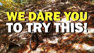
One of the only lines in the area deserving of a double black diamond. The trail is a straight shot from the top of the credit valley to the bottom at the Culham Trail. Very eroded which only adds to the challenge, plenty of rocks and roots. Sometimes referred too as Suicide.

This trail is unsanctioned.

Recent Activity on Trail

Past Week
  • 0 rides
  •  
6 Months
  • 0 rides
  •  
All
  • 6 rides
  • Last: Apr 11, 2026
c1c2c3c4
January
February
March
April
May
June
July
August
September
October
November
December
update trails status or condition

Death Root Trail Reports

statusdatedescription
Apr 15, 2022 @ 1:00pm
Apr 15, 2022
Clear some logs and debris, line is ready to go
Apr 8, 2021 @ 3:56pm
Apr 8, 2021
Removed more deadfall from the top and re-opened the original entrance riders right. The trail is a lot more possible to ride now. Pick your lines...
May 2, 2020 @ 5:36pm
May 2, 2020
Removed large fallen tree at the beginning of the run. Cleaned out other deadfall and cemented the mainline. Open for business!
more »
Status:
on Apr 15, 2022
Dry
Avg: 4.13 (1 votes)
Your vote: 0

view (47)
close
3D
Trail Conditions
  • Unknown
  • Snow Groomed
  • Snow Packed
  • Snow Covered
  • Snow Cover Partial
  • Freeze/thaw Cycle
  • Icy
  • Prevalent Mud
  • Wet
  • Variable
  • Ideal
  • Dry
  • Very Dry
Trail Flow (Ridden Direction)
Trailforks scans users ridelogs to determine the most popular direction each trail is ridden. A good flowing trail network will have most trails flowing in a single direction according to their intension.
The colour categories are based on what percentage of riders are riding a trail in its intended direction.
  • > 96%
  • > 90%
  • > 80%
  • > 70%
  • > 50%
  • < 50%
  • bi-directional trail
  • no data
Trail Last Ridden
Trailforks scans ridelogs to determine the last time a trail was ridden.
  • < 2 days
  • < 1 week
  • < 2 weeks
  • < 1 month
  • < 6 months
  • > 6 months
Trail Ridden Direction
The intended direction a trail should be ridden.
  • Downhill Only
  • Downhill Primary
  • Both Directions
  • Uphill Primary
  • Uphill Only
  • One Direction
Contribute Details
Colors indicate trail is missing specified detail.
  • Description
  • Photos
  • Description & Photos
  • Videos
Trail Popularity ?
Trailforks scans ridelogs to determine which trails are ridden the most in the last 9 months. Trails are compared with nearby trails in the same city region with a possible 25 colour shades. Think of this as a heatmap, more rides = more kinetic energy = warmer colors.
  • most popular
  • popular
  • less popular
  • not popular
ATV/ORV/OHV Filter
Max Vehicle Width
inches
US Cell Coverage
Legend
cell carrier legend

Radar Time
Activity Recordings
Trailforks uses anonymized public activity data. ?
Activity Recordings
Trailforks uses anonymized public activity data. ?
Personal Heatmap
Activity Types
all / none
Options
2
Date range month
Winter Trails
Warning A routing network for winter maps does not exist. Selecting trails using the winter trails layer has been disabled.
Missing Trails
Most Popular
Least Popular
Trails are colored based on popularity. The more popular a trail is, the more red. Less popular trails trend towards green.
Jump Magnitude Heatmap
Heatmap of where riders jump on trails. Zoom in to see individual jumps, click circles to view jump details.
BC Backroad Status

Service Road Atlas is a free to use, community-driven service for viewing and creating reports on the numerous back-country service roads around B.C. and Alberta.

map legend
Slope Aspect
Direction the slope faces
Flat N NE E SE S SW W NW
Trails Deemphasized
Trails are shown in grey.
disable
Only show trails with no bike usage.
Enable
Suggested Layers
Based on selected activity type

    Save the current map location and zoom level as your default home location whenever this page is loaded.

    Save
        Directions to death-root trailhead (43.557670, -79.668050)

        Photos

        30 more »
        97 |
        Oct 16, 2020 @ 10:40am
        Oct 16, 2020
        84 |
        Aug 21, 2020 @ 10:20am
        Aug 21, 2020
        90 |
        Aug 21, 2020 @ 10:19am
        Aug 21, 2020
        162 |
        May 2, 2020 @ 5:41pm
        May 2, 2020

        Videos

        1 more »
        youtuber We Challenge YOU To Try This Insane Trail!
        8:51 | 260 | Oct 10, 2020 , Mississauga

        1 Review & Comments


        We hope you've been enjoying Trailforks!

        Create a FREE account to view trail comments and much more.

        • #278529 - 1,608 views

        Frequently Asked Questions About Death Root

        Where is Death Root located?
        Death Root is located in Mississauga, Ontario, Canada. It is part of the Mississauga trail network. The trailhead is located at coordinates 43.55767, -79.66805.
        How hard is Death Root?
        Death Root is rated as Double Black Diamond difficulty. The physical rating is Hard. The average grade is 4.8%.
        What is the elevation gain for Death Root?
        The trail has 2 m of elevation descent. The elevation ranges from 121 m to 123 m.
        Is Death Root a point to point trail?
        Yes, Death Root is a point to point trail. The direction is Downhill Only. The trail type is singletrack.

        Hit the Trail

        Open in App

        Get this trail on your phone instantly.
        open trail in app

        Download Trail

        Save to wishlist, Garmin & download.
        save the trail

        Find Related Routes

        Find routes and users activities that include this trail.
        find routes for this trail

        You must enter a description before submitting.