more stats
825 ft
Distance
3 ft
Climb
-136 ft
Descent
00:01:32
Avg time
-134 ft
Altitude change
895 ft
Altitude min
1,031 ft
Altitude max
1,031 ft
Altitude start
897 ft
Altitude end
-69.283%
Grade max
4.385%
Grade min
61 ft
Distance climb
663 ft
Distance down
101 ft
Distance flat
00:01:32
Avg time

Deep Navigation Details

  • Activities
    • Mountain Bike
    • E-Bike
  • Riding Area
    BikePark Wales
    Abercanaid
  • Difficulty Rating
  • Local Popularity
    85 in Mountain Biking [+]
    • 75 in E-Biking
  • Global Ranking
    #1148 in Mountain Biking [+]
    • #32899 in E-Biking
  • Trail Type
    Singletrack
  • Bike Type
    DH, AM
  • Direction
    Downhill Only
    Popular Direction Shown
  • eBike Allowed
    Yes up to Class 1
  • TTFs on Trail
    Berm, Drop, Jump, Rock Garden, Other
  • Land Owner

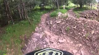
Named after a giant coal mine in the area that closed in 1991 Deep Navigation follows the route of the legendary "Dragon rock garden" one of the longest and most infamous rock gardens in the UK. Pick your line carefully as this one will catch you unawares if you aren't on top of your game.

Bike Park

Recent Activity on Trail

Past Week
  • 11 rides
  • 20 miles average
6 Months
  • 112 rides
  • 30 miles avg distance
All
  • 676 rides
  • Last: Jun 4, 2026
c1c2c3c4
January
February
March
April
May
June
July
August
September
October
November
December
Status:
on Apr 11, 2025
Very Dry
Avg: 4.2 (14 votes)
Your vote: 0

view (14,914)
close
3D
Trail Conditions
  • Unknown
  • Snow Groomed
  • Snow Packed
  • Snow Covered
  • Snow Cover Partial
  • Freeze/thaw Cycle
  • Icy
  • Prevalent Mud
  • Wet
  • Variable
  • Ideal
  • Dry
  • Very Dry
Trail Flow (Ridden Direction)
Trailforks scans users ridelogs to determine the most popular direction each trail is ridden. A good flowing trail network will have most trails flowing in a single direction according to their intension.
The colour categories are based on what percentage of riders are riding a trail in its intended direction.
  • > 96%
  • > 90%
  • > 80%
  • > 70%
  • > 50%
  • < 50%
  • bi-directional trail
  • no data
Trail Last Ridden
Trailforks scans ridelogs to determine the last time a trail was ridden.
  • < 2 days
  • < 1 week
  • < 2 weeks
  • < 1 month
  • < 6 months
  • > 6 months
Trail Ridden Direction
The intended direction a trail should be ridden.
  • Downhill Only
  • Downhill Primary
  • Both Directions
  • Uphill Primary
  • Uphill Only
  • One Direction
Contribute Details
Colors indicate trail is missing specified detail.
  • Description
  • Photos
  • Description & Photos
  • Videos
Trail Popularity ?
Trailforks scans ridelogs to determine which trails are ridden the most in the last 9 months. Trails are compared with nearby trails in the same city region with a possible 25 colour shades. Think of this as a heatmap, more rides = more kinetic energy = warmer colors.
  • most popular
  • popular
  • less popular
  • not popular
ATV/ORV/OHV Filter
Max Vehicle Width
inches
US Cell Coverage
Legend
cell carrier legend

Radar Time
Activity Recordings
Trailforks uses anonymized public activity data. ?
Activity Recordings
Trailforks uses anonymized public activity data. ?
Personal Heatmap
Activity Types
all / none
Options
2
Date range month
Winter Trails
Warning A routing network for winter maps does not exist. Selecting trails using the winter trails layer has been disabled.
Missing Trails
Most Popular
Least Popular
Trails are colored based on popularity. The more popular a trail is, the more red. Less popular trails trend towards green.
Jump Magnitude Heatmap
Heatmap of where riders jump on trails. Zoom in to see individual jumps, click circles to view jump details.
BC Backroad Status

Service Road Atlas is a free to use, community-driven service for viewing and creating reports on the numerous back-country service roads around B.C. and Alberta.

map legend
Slope Aspect
Direction the slope faces
Flat N NE E SE S SW W NW
Trails Deemphasized
Trails are shown in grey.
disable
Only show trails with no bike usage.
Enable
Suggested Layers
Based on selected activity type

    Save the current map location and zoom level as your default home location whenever this page is loaded.

    Save
        Directions to deep-navigation trailhead (51.720330, -3.379430)

        Photos

        No photos have been added for Deep Navigation yet, add a photo.

        Videos

        6 more »
        Deep Navigation - Bike Park Wales 2024
        0:00 | 120 | May 10, 2024 , Abercanaid
        youtuber Best Bike Park In The UK - Bike Park Wales
        15:21 | 357 | Nov 10, 2018 , Abercanaid
        Bike Park Wales Deep Navigation - Black - 2018
        0:12 | 498 | Aug 6, 2018 , Abercanaid
        Deep Navigation
        1304 | Oct 23, 2014 , Abercanaid

        Reviews / Comments

        No reviews yet, be the first to write a review or ask a question.
        Use trail reports to comment on trail conditions.


        We hope you've been enjoying Trailforks!

        Create a FREE account to view trail comments and much more.

        Frequently Asked Questions About Deep Navigation

        Where is Deep Navigation located?
        Deep Navigation is located in BikePark Wales, Abercanaid, United Kingdom. It is part of the BikePark Wales trail network. The trailhead is located at coordinates 51.72033, -3.37943.
        How hard is Deep Navigation?
        Deep Navigation is rated as Black difficulty.
        What is the elevation gain for Deep Navigation?
        Deep Navigation has 1 m of elevation gain. The trail has 42 m of elevation descent. The elevation ranges from 273 m to 314 m.
        Is Deep Navigation a point to point trail?
        Yes, Deep Navigation is a point to point trail. The direction is Downhill Only. The trail type is singletrack.

        Hit the Trail

        Open in App

        Get this trail on your phone instantly.
        open trail in app

        Download Trail

        Save to wishlist, Garmin & download.
        save the trail

        Find Related Routes

        Find routes and users activities that include this trail.
        find routes for this trail

        You must enter a description before submitting.