more stats
2.5 miles
Distance
602 ft
Climb
-622 ft
Descent
00:20:04
Avg time
-20 ft
Altitude change
1,779 ft
Altitude min
2,083 ft
Altitude max
2,083 ft
Altitude start
2,064 ft
Altitude end
-0.1%
Grade
-34.9%
Grade max
60.1%
Grade min
1 mile
Distance climb
1 mile
Distance down
1,729 ft
Distance flat
00:20:04
Avg time

Defibrillator Details

  • Activities
    • Mountain Bike
    • E-Bike
    • Adaptive Bike
  • Riding Area
    Jubilee Park
    Toowoomba
  • Difficulty Rating
  • Local Popularity
    100 in Mountain Biking [+]
    • 90 in E-Biking
  • Global Ranking
    #4482 in Mountain Biking [+]
    • #3457 in E-Biking
  • Trail Type
    Singletrack
  • Bike Type
    AM, XC, Adaptive MTB
  • Direction
    One Direction
  • Climb Difficulty
    Green
  • Physical Rating
    Easy
  • Trail Visibility
    Always easy to follow
  • Family Friendly
    Yes
  • eBike Allowed
    Yes up to Class 1
  • TTFs on Trail
    Berm, Jump

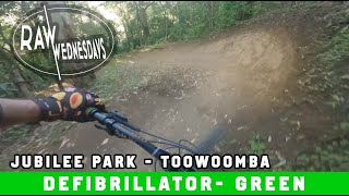
Originally designed as a climbing trail, Defibrillator has been recently machined to make the best flow trail loop in the park. The descent is now one way to improve safety and the new climb is a steady gradient.

Adaptive Bike Info
aMTB Green Rating: Beginner features and moderate terrain.

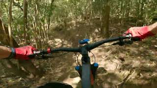
Feels a bit narrow but is wide enough the whole way around

Trail Supporters
Local Trail Association
Traditionally Indigenous Territory

Recent Activity on Trail

Past Week
  • 2 rides
  • 7 miles average
6 Months
  • 40 rides
  • 9 miles avg distance
All
  • 565 rides
  • Last: Jul 4, 2026
c1c2c3c4
January
February
March
April
May
June
July
August
September
October
November
December
update trails status or condition

Defibrillator Trail Reports

statusdatedescription
Feb 22, 2026 @ 7:18pm (Australia/Brisbane)
Feb 22, 2026
Apr 25, 2024 @ 9:43pm
Apr 25, 2024
Oct 29, 2023 @ 1:17pm
Oct 29, 2023
Defib is now completely open and packed with a tone of new jumps!
Sep 16, 2023 @ 12:10am
Sep 16, 2023
THE CLIMB IS OPEN FROM THE Half way point, the downhill section is closed for rebuilt!
May 12, 2023 @ 2:10am
May 12, 2023
more »
Status:
on Feb 22, 2026
Ideal
Avg: 4.53 (9 votes)
Your vote: 0

view (14,060)
close
3D
Trail Conditions
  • Unknown
  • Snow Groomed
  • Snow Packed
  • Snow Covered
  • Snow Cover Partial
  • Freeze/thaw Cycle
  • Icy
  • Prevalent Mud
  • Wet
  • Variable
  • Ideal
  • Dry
  • Very Dry
Trail Flow (Ridden Direction)
Trailforks scans users ridelogs to determine the most popular direction each trail is ridden. A good flowing trail network will have most trails flowing in a single direction according to their intension.
The colour categories are based on what percentage of riders are riding a trail in its intended direction.
  • > 96%
  • > 90%
  • > 80%
  • > 70%
  • > 50%
  • < 50%
  • bi-directional trail
  • no data
Trail Last Ridden
Trailforks scans ridelogs to determine the last time a trail was ridden.
  • < 2 days
  • < 1 week
  • < 2 weeks
  • < 1 month
  • < 6 months
  • > 6 months
Trail Ridden Direction
The intended direction a trail should be ridden.
  • Downhill Only
  • Downhill Primary
  • Both Directions
  • Uphill Primary
  • Uphill Only
  • One Direction
Contribute Details
Colors indicate trail is missing specified detail.
  • Description
  • Photos
  • Description & Photos
  • Videos
Trail Popularity ?
Trailforks scans ridelogs to determine which trails are ridden the most in the last 9 months. Trails are compared with nearby trails in the same city region with a possible 25 colour shades. Think of this as a heatmap, more rides = more kinetic energy = warmer colors.
  • most popular
  • popular
  • less popular
  • not popular
ATV/ORV/OHV Filter
Max Vehicle Width
inches
US Cell Coverage
Legend
cell carrier legend

Radar Time
Activity Recordings
Trailforks uses anonymized public activity data. ?
Activity Recordings
Trailforks uses anonymized public activity data. ?
Personal Heatmap
Activity Types
all / none
Options
2
Date range month
Winter Trails
Warning A routing network for winter maps does not exist. Selecting trails using the winter trails layer has been disabled.
Missing Trails
Most Popular
Least Popular
Trails are colored based on popularity. The more popular a trail is, the more red. Less popular trails trend towards green.
Jump Magnitude Heatmap
Heatmap of where riders jump on trails. Zoom in to see individual jumps, click circles to view jump details.
BC Backroad Status

Service Road Atlas is a free to use, community-driven service for viewing and creating reports on the numerous back-country service roads around B.C. and Alberta.

map legend
Slope Aspect
Direction the slope faces
Flat N NE E SE S SW W NW
Trails Deemphasized
Trails are shown in grey.
disable
Only show trails with no bike usage.
Enable
Suggested Layers
Based on selected activity type

    Save the current map location and zoom level as your default home location whenever this page is loaded.

    Save
        Directions to defibrillator trailhead (-27.555460, 151.981810)

        Photos

        7 more »
        139 |
        Jul 17, 2022 @ 3:26am
        Jul 17, 2022
        160 |
        Jul 17, 2022 @ 3:20am
        Jul 17, 2022
        40 |
        May 5, 2025 @ 4:46pm
        May 5, 2025
        190 |
        Aug 29, 2020 @ 11:01pm
        Aug 29, 2020

        Videos

        6 more »
        Jubilee Park Toowoomba MTB Trails - Defibrillator
        6:56 | 150 | Aug 6, 2024 , Toowoomba
        youtuber DEFIBRILLATOR | Jubilee Park | RAW WEDNESDAYS
        4:29 | 623 | Dec 29, 2021 , Toowoomba
        youtuber Jubilee - Defibrillator (down) TRAIL 2021
        5:09 | 569 | Jan 1, 2021 , Toowoomba
        youtuber Isolation Inspiration! RAW POV footage for...
        15:27 | 579 | Apr 23, 2020 , Toowoomba

        Routes with this trail

        13 miles 2,760 ft 65 Race
        Queensland Enduro Series round 2 Jubilee
        14 miles 3,344 ft 61 Loop Race
        Round 2 of SEQ Enduro Series
        2 miles 407 ft 5 Race
        Stage 1 of Fox on Rocks Covid edition 1 November 2020 Defibrillator, one of our most recent trail...

        3 Reviews & Comments


        We hope you've been enjoying Trailforks!

        Create a FREE account to view trail comments and much more.

        • By aaroncobTF Pro & contributors
        • #50195 - 6,807 views

        Frequently Asked Questions About Defibrillator

        Where is Defibrillator located?
        Defibrillator is located in Jubilee Park, Toowoomba, Australia. It is part of the Jubilee Park trail network. The trailhead is located at coordinates -27.55546, 151.98181.
        How hard is Defibrillator?
        Defibrillator is rated as Green difficulty. The physical rating is Easy. The average grade is 0.1%. The climb difficulty is rated Green.
        What is the elevation gain for Defibrillator?
        Defibrillator has 184 m of elevation gain. The trail has 190 m of elevation descent. The elevation ranges from 542 m to 635 m.
        Is Defibrillator a point to point trail?
        Yes, Defibrillator is a point to point trail. The direction is One Direction. The trail type is singletrack.

        Hit the Trail

        Open in App

        Get this trail on your phone instantly.
        open trail in app

        Download Trail

        Save to wishlist, Garmin & download.
        save the trail

        Find Related Routes

        Find routes and users activities that include this trail.
        find routes for this trail

        You must enter a description before submitting.