more stats
3,609 ft
Distance
-636 ft
Descent
00:07:55
Avg time
-636 ft
Altitude change
999 ft
Altitude min
1,635 ft
Altitude max
1,635 ft
Altitude start
1,001 ft
Altitude end
-17.6%
Grade
-56.2%
Grade max
-2.4%
Grade min
3,563 ft
Distance down
46 ft
Distance flat
00:07:55
Avg time

Dele Details

  • Activities
    • Mountain Bike
    • Hike
    • Trail Running
  • Riding Area
  • Difficulty Rating
  • Voted Difficulty
    Blue (1 vote)
  • Local Popularity
    35 in Mountain Biking [+]
    • 5 in Trail Running
    • 5 in Hiking
  • Global Ranking
    #123482 in Mountain Biking [+]
    • #140339 in Trail Running
    • #134650 in Hiking
  • Trail Type
    Singletrack
  • Bike Type
    DH, AM
  • Direction
    Downhill Primary
    Popular Direction Shown
  • Climb Difficulty
    Blue
  • Physical Rating
    Moderate
  • Dogs Allowed
    Yes
  • TTFs on Trail
    Log Ride

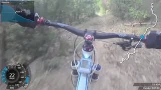
Sentiero nei boschi sopra Deiva Marina. Facilmente raggiungibile dalla strada del Bracco - aurelia - scendendo in direzione Deiva Marina o Facendo prima il sentiero persico partendo dal Passo del Bracco.
Sentiero inizialmente veloce e poi sempre si tecnico con tornantini, molto bello.

Recent Activity on Trail

Past Week
  • 0 rides
  •  
6 Months
  • 0 rides
  •  
All
  • 25 rides
  • Last: Mar 28, 2026
c1c2c3c4
January
February
March
April
May
June
July
August
September
October
November
December
update trails status or condition

Dele Trail Reports

statusdatedescription
Nov 12, 2024 @ 6:05am
Nov 12, 2024
ormai abbandonato e pieno di foglie e bacchi...inutile che i trail builder lo tengano aperto visto che c'e' il 700 che è molto piu bello.
May 12, 2024 @ 6:56am
May 12, 2024
il trail di fatto non esiste più. Percorso ieri, avanzi a fatica tra i rovi, un tappeto marcente di foglie, sassi smossi e alberi caduti
May 4, 2024 @ 12:43am
May 4, 2024
Il trail ultimamente è molto malandato, almeno fino a metà percorso. molte pietre smosse e pezzi di rami caduti. Si riconferma grosso tronco...
Apr 15, 2024 @ 12:21am
Apr 15, 2024
purtroppo soffre di incuria...bello ma andrebbe ripulito
Jan 30, 2024 @ 2:08am
Jan 30, 2024
Confermo foglie su quasi tutto il tracciato e grosso tronco.
more »
Status:
on Nov 12, 2024
Avg: 3.81 (5 votes)
Your vote: 0

view (167)
close
3D
Trail Conditions
  • Unknown
  • Snow Groomed
  • Snow Packed
  • Snow Covered
  • Snow Cover Partial
  • Freeze/thaw Cycle
  • Icy
  • Prevalent Mud
  • Wet
  • Variable
  • Ideal
  • Dry
  • Very Dry
Trail Flow (Ridden Direction)
Trailforks scans users ridelogs to determine the most popular direction each trail is ridden. A good flowing trail network will have most trails flowing in a single direction according to their intension.
The colour categories are based on what percentage of riders are riding a trail in its intended direction.
  • > 96%
  • > 90%
  • > 80%
  • > 70%
  • > 50%
  • < 50%
  • bi-directional trail
  • no data
Trail Last Ridden
Trailforks scans ridelogs to determine the last time a trail was ridden.
  • < 2 days
  • < 1 week
  • < 2 weeks
  • < 1 month
  • < 6 months
  • > 6 months
Trail Ridden Direction
The intended direction a trail should be ridden.
  • Downhill Only
  • Downhill Primary
  • Both Directions
  • Uphill Primary
  • Uphill Only
  • One Direction
Contribute Details
Colors indicate trail is missing specified detail.
  • Description
  • Photos
  • Description & Photos
  • Videos
Trail Popularity ?
Trailforks scans ridelogs to determine which trails are ridden the most in the last 9 months. Trails are compared with nearby trails in the same city region with a possible 25 colour shades. Think of this as a heatmap, more rides = more kinetic energy = warmer colors.
  • most popular
  • popular
  • less popular
  • not popular
ATV/ORV/OHV Filter
Max Vehicle Width
inches
US Cell Coverage
Legend
cell carrier legend

Radar Time
Activity Recordings
Trailforks uses anonymized public activity data. ?
Activity Recordings
Trailforks uses anonymized public activity data. ?
Personal Heatmap
Activity Types
all / none
Options
2
Date range month
Winter Trails
Warning A routing network for winter maps does not exist. Selecting trails using the winter trails layer has been disabled.
Missing Trails
Most Popular
Least Popular
Trails are colored based on popularity. The more popular a trail is, the more red. Less popular trails trend towards green.
Jump Magnitude Heatmap
Heatmap of where riders jump on trails. Zoom in to see individual jumps, click circles to view jump details.
BC Backroad Status

Service Road Atlas is a free to use, community-driven service for viewing and creating reports on the numerous back-country service roads around B.C. and Alberta.

map legend
Slope Aspect
Direction the slope faces
Flat N NE E SE S SW W NW
Trails Deemphasized
Trails are shown in grey.
disable
Only show trails with no bike usage.
Enable
Suggested Layers
Based on selected activity type

    Save the current map location and zoom level as your default home location whenever this page is loaded.

    Save
        Directions to dele trailhead (44.252410, 9.547320)

        Photos

        2 more »
        123 |
        Nov 30, 2019 @ 8:39am
        Nov 30, 2019
        39 |
        Dec 3, 2023 @ 11:18pm
        Dec 3, 2023

        Videos

        2 more »
        Mtb Deiva Dele
        6:51 | 552 | Mar 16, 2018 , Deiva Marina
        Moneglia Freeride La Dele
        587 | Jul 14, 2017 , Deiva Marina

        Routes with this trail

        15 miles 2,371 ft 3 Loop
        Bellissimo giro Enduro/Freeride da Moneglia a Deiva, per rientrare a Moneglia si può prendere il treno,...
        17 miles 3,391 ft 3 Loop
        Bel giro Enduro/Freeride ad anello che parte da Framura. Tocca i sentieri , , e Deiva

        3 Reviews & Comments


        We hope you've been enjoying Trailforks!

        Create a FREE account to view trail comments and much more.

        Nearby Trails

        • By j8lud & contributors
        • #95492 - 1,521 views

        Frequently Asked Questions About Dele

        Where is Dele located?
        Dele is located in Deiva Marina, Italy. It is part of the Deiva Marina trail network. The trailhead is located at coordinates 44.25241, 9.54732.
        How hard is Dele?
        Dele is rated as Red difficulty. The physical rating is Moderate. The average grade is 17.6%. The climb difficulty is rated Blue.
        What is the elevation gain for Dele?
        The trail has 636 ft of elevation descent. The elevation ranges from 999 ft to 1,635 ft.
        Is Dele a point to point trail?
        Dele is not a point to point trail. The direction is Downhill Primary. The trail type is singletrack.

        Hit the Trail

        Open in App

        Get this trail on your phone instantly.
        open trail in app

        Download Trail

        Save to wishlist, Garmin & download.
        save the trail

        Find Related Routes

        Find routes and users activities that include this trail.
        find routes for this trail

        You must enter a description before submitting.