more stats
883 ft
Distance
-153 ft
Descent
00:02:49
Avg time
-153 ft
Altitude change
456 ft
Altitude min
609 ft
Altitude max
609 ft
Altitude start
456 ft
Altitude end
-17.4%
Grade
-44.9%
Grade max
-1.1%
Grade min
820 ft
Distance down
62 ft
Distance flat
00:02:49
Avg time

Desperate Dan Details

  • Activities
    • Mountain Bike
    • E-Bike
    • Hike
    • Trail Running
  • Riding Area
    Trinity Hill Woods
    Axminster
  • Difficulty Rating
  • Local Popularity
    100 in Mountain Biking [+]
    • 100 in E-Biking
    • 5 in Trail Running
    • 5 in Hiking
  • Global Ranking
    #127389 in Mountain Biking [+]
    • #6428 in E-Biking
    • #139309 in Trail Running
    • #133389 in Hiking
  • Trail Type
    Singletrack
  • Bike Type
    DH, AM
  • Physical Rating
    Moderate
  • Dogs Allowed
    Yes
  • eBike Allowed
  • TTFs on Trail
    Drop, Jump, Gap Jump

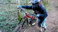
From the fire road - Cross through the grass and follow the flattened long grass. Follow your nose and look out for the drops. Short fast and fun. Mind the Barbwire as you get out onto the road.
*tree down recently so there start is tucked away 15m from the fire road.

This trail is unsanctioned.

Recent Activity on Trail

Past Week
  • 2 rides
  • 7 miles average
6 Months
  • 7 rides
  • 8 miles avg distance
All
  • 14 rides
  • Last: Jul 2, 2026
c1c2c3c4
January
February
March
April
May
June
July
August
September
October
November
December
update trails status or condition

Desperate Dan Trail Reports

statusdatedescription
Jun 30, 2024 @ 9:59am
Jun 30, 2024
May 20, 2020 @ 9:47am
May 20, 2020
Great trail
Jun 22, 2019 @ 10:52am
Jun 22, 2019
Watch out for trees - cleared it but a few have come down
May 10, 2019 @ 7:37am
May 10, 2019
Feb 11, 2019 @ 3:34pm
Feb 11, 2019
Tree down at the top and barbed wire fence at bottom of trail
more »
Status:
on Jun 30, 2024
Very Dry
no votes yet
Your vote: 0

view (143)
close
3D
Trail Conditions
  • Unknown
  • Snow Groomed
  • Snow Packed
  • Snow Covered
  • Snow Cover Partial
  • Freeze/thaw Cycle
  • Icy
  • Prevalent Mud
  • Wet
  • Variable
  • Ideal
  • Dry
  • Very Dry
Trail Flow (Ridden Direction)
Trailforks scans users ridelogs to determine the most popular direction each trail is ridden. A good flowing trail network will have most trails flowing in a single direction according to their intension.
The colour categories are based on what percentage of riders are riding a trail in its intended direction.
  • > 96%
  • > 90%
  • > 80%
  • > 70%
  • > 50%
  • < 50%
  • bi-directional trail
  • no data
Trail Last Ridden
Trailforks scans ridelogs to determine the last time a trail was ridden.
  • < 2 days
  • < 1 week
  • < 2 weeks
  • < 1 month
  • < 6 months
  • > 6 months
Trail Ridden Direction
The intended direction a trail should be ridden.
  • Downhill Only
  • Downhill Primary
  • Both Directions
  • Uphill Primary
  • Uphill Only
  • One Direction
Contribute Details
Colors indicate trail is missing specified detail.
  • Description
  • Photos
  • Description & Photos
  • Videos
Trail Popularity ?
Trailforks scans ridelogs to determine which trails are ridden the most in the last 9 months. Trails are compared with nearby trails in the same city region with a possible 25 colour shades. Think of this as a heatmap, more rides = more kinetic energy = warmer colors.
  • most popular
  • popular
  • less popular
  • not popular
ATV/ORV/OHV Filter
Max Vehicle Width
inches
US Cell Coverage
Legend
cell carrier legend

Radar Time
Activity Recordings
Trailforks uses anonymized public activity data. ?
Activity Recordings
Trailforks uses anonymized public activity data. ?
Personal Heatmap
Activity Types
all / none
Options
2
Date range month
Winter Trails
Warning A routing network for winter maps does not exist. Selecting trails using the winter trails layer has been disabled.
Missing Trails
Most Popular
Least Popular
Trails are colored based on popularity. The more popular a trail is, the more red. Less popular trails trend towards green.
Jump Magnitude Heatmap
Heatmap of where riders jump on trails. Zoom in to see individual jumps, click circles to view jump details.
BC Backroad Status

Service Road Atlas is a free to use, community-driven service for viewing and creating reports on the numerous back-country service roads around B.C. and Alberta.

map legend
Slope Aspect
Direction the slope faces
Flat N NE E SE S SW W NW
Trails Deemphasized
Trails are shown in grey.
disable
Only show trails with no bike usage.
Enable
Suggested Layers
Based on selected activity type

    Save the current map location and zoom level as your default home location whenever this page is loaded.

    Save
        Directions to desperate-dan trailhead (50.749730, -2.978880)

        Photos

        No photos have been added for Desperate Dan yet, add a photo.

        Videos

        20 more »
        Weekend Go Pro
        2:23 | 244 | Jan 24, 2012 , Axminster
        Winter wetness
        0:22 | 543 | Dec 13, 2014 , Axminster
        Afternoon ride up the local
        0:54 | 92 | Oct 24, 2012 , Axminster
        Afternoon ride up the local
        0:39 | 44 | Oct 24, 2012 , Axminster

        1 Review & Comments


        We hope you've been enjoying Trailforks!

        Create a FREE account to view trail comments and much more.

        • #160131 - 1,824 views

        Frequently Asked Questions About Desperate Dan

        Where is Desperate Dan located?
        Desperate Dan is located in Trinity Hill Woods, Axminster, United Kingdom. It is part of the Trinity Hill Woods trail network. The trailhead is located at coordinates 50.74973, -2.97888.
        How hard is Desperate Dan?
        Desperate Dan is rated as Red difficulty. The physical rating is Moderate. The average grade is 17.4%.
        What is the elevation gain for Desperate Dan?
        The trail has 153 ft of elevation descent. The elevation ranges from 456 ft to 609 ft.
        How long is Desperate Dan?
        Desperate Dan is 883 ft long. The trail type is singletrack.

        Hit the Trail

        Open in App

        Get this trail on your phone instantly.
        open trail in app

        Download Trail

        Save to wishlist, Garmin & download.
        save the trail

        Find Related Routes

        Find routes and users activities that include this trail.
        find routes for this trail

        You must enter a description before submitting.