more stats
823 ft
Distance
-106 ft
Descent
00:01:07
Avg time
-106 ft
Altitude change
7,917 ft
Altitude min
8,023 ft
Altitude max
8,023 ft
Altitude start
7,917 ft
Altitude end
-12.8%
Grade
-30.4%
Grade max
-3.1%
Grade min
823 ft
Distance down
00:01:07
Avg time

Devo (Harder) Details

  • Activities
    • Mountain Bike
  • Riding Area
    Deer Valley Resort
    Park City, Utah
  • Difficulty Rating
  • Voted Difficulty
    Black Diamond (2 votes)
  • Local Popularity
    75 in Mountain Biking
  • Global Ranking
    #102853 in Mountain Biking
  • Trail Type
    Singletrack
  • Bike Type
    DH, AM
  • Direction
    Downhill Only
  • Physical Rating
    Hard
  • Trail Visibility
    Always easy to follow
  • eBike Allowed
  • TTFs on Trail
    Rock Garden
  • Land Owner
    Deer Valley Resort

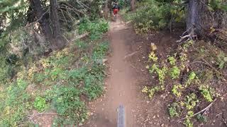
This is the "Harder" section at the Devo Fork. It starts with a short rock drop, then you take a right at the fork. Right after you pass by the turn off for Old School the trail goes right into a jagged rock garden through the trees. It is full of wheel traps and is almost flat, so you have to pedal through parts of it.

Bike Park

Local Trail Association
  • trail association logo
  • Please consider joining or donating to the local trail association to support
    trail development & maintenance.
Traditionally Indigenous Territory

Recent Activity on Trail

Past Week
  • 1 rides
  • 21 miles average
6 Months
  • 11 rides
  • 21 miles avg distance
All
  • 284 rides
  • Last: Jun 2, 2026
c1c2c3c4
January
February
March
April
May
June
July
August
September
October
November
December
update trails status or condition

Devo (Harder) Trail Reports

statusdatedescription
Apr 16, 2026 @ 11:25am (America/Denver)
Apr 16, 2026
reporter Seasonal Closure
Apr 16, 2026 @ 10:51am (America/Denver)
Apr 16, 2026
Oct 13, 2025 @ 8:04am (America/Denver)
Oct 13, 2025
reporter closed for the season will reopen Spring 2026
Aug 30, 2025 @ 9:44am
Aug 30, 2025
reporter Recent rains have improved conditions.
Jun 20, 2025 @ 4:31pm
Jun 20, 2025
reporter
more »
Status:
on Apr 16, 2026
Snow Covered
Avg: 3.81 (5 votes)
Your vote: 0

view (3,096)
close
3D
Trail Conditions
  • Unknown
  • Snow Groomed
  • Snow Packed
  • Snow Covered
  • Snow Cover Partial
  • Freeze/thaw Cycle
  • Icy
  • Prevalent Mud
  • Wet
  • Variable
  • Ideal
  • Dry
  • Very Dry
Trail Flow (Ridden Direction)
Trailforks scans users ridelogs to determine the most popular direction each trail is ridden. A good flowing trail network will have most trails flowing in a single direction according to their intension.
The colour categories are based on what percentage of riders are riding a trail in its intended direction.
  • > 96%
  • > 90%
  • > 80%
  • > 70%
  • > 50%
  • < 50%
  • bi-directional trail
  • no data
Trail Last Ridden
Trailforks scans ridelogs to determine the last time a trail was ridden.
  • < 2 days
  • < 1 week
  • < 2 weeks
  • < 1 month
  • < 6 months
  • > 6 months
Trail Ridden Direction
The intended direction a trail should be ridden.
  • Downhill Only
  • Downhill Primary
  • Both Directions
  • Uphill Primary
  • Uphill Only
  • One Direction
Contribute Details
Colors indicate trail is missing specified detail.
  • Description
  • Photos
  • Description & Photos
  • Videos
Trail Popularity ?
Trailforks scans ridelogs to determine which trails are ridden the most in the last 9 months. Trails are compared with nearby trails in the same city region with a possible 25 colour shades. Think of this as a heatmap, more rides = more kinetic energy = warmer colors.
  • most popular
  • popular
  • less popular
  • not popular
ATV/ORV/OHV Filter
Max Vehicle Width
inches
US Cell Coverage
Legend
cell carrier legend

Radar Time
Activity Recordings
Trailforks uses anonymized public activity data. ?
Activity Recordings
Trailforks uses anonymized public activity data. ?
Personal Heatmap
Activity Types
all / none
Options
2
Date range month
Winter Trails
Warning A routing network for winter maps does not exist. Selecting trails using the winter trails layer has been disabled.
Missing Trails
Most Popular
Least Popular
Trails are colored based on popularity. The more popular a trail is, the more red. Less popular trails trend towards green.
Jump Magnitude Heatmap
Heatmap of where riders jump on trails. Zoom in to see individual jumps, click circles to view jump details.
BC Backroad Status

Service Road Atlas is a free to use, community-driven service for viewing and creating reports on the numerous back-country service roads around B.C. and Alberta.

map legend
Slope Aspect
Direction the slope faces
Flat N NE E SE S SW W NW
Trails Deemphasized
Trails are shown in grey.
disable
Only show trails with no bike usage.
Enable
Suggested Layers
Based on selected activity type

    Save the current map location and zoom level as your default home location whenever this page is loaded.

    Save
        Directions to devo-harder trailhead (40.628930, -111.483700)

        Photos

        1 more »
        114 |
        Jun 17, 2018 @ 1:35pm
        Jun 17, 2018

        Videos

        1 more »
        Devo Trail in Deer Valley
        5:38 | 678 | Sep 1, 2020 , Park City

        4 Reviews & Comments


        We hope you've been enjoying Trailforks!

        Create a FREE account to view trail comments and much more.

        • By toddTF Pro Trailforks & contributors
        • #134846 - 1,460 views

        Frequently Asked Questions About Devo (Harder)

        Where is Devo (Harder) located?
        Devo (Harder) is located in Deer Valley Resort, Park City, Utah, United States. It is part of the Deer Valley Resort trail network. The trailhead is located at coordinates 40.62893, -111.4837.
        How hard is Devo (Harder)?
        Devo (Harder) is rated as Double Black Diamond difficulty. The physical rating is Hard. The average grade is 12.8%.
        What is the elevation gain for Devo (Harder)?
        The trail has 106 ft of elevation descent. The elevation ranges from 7,917 ft to 8,023 ft.
        Is Devo (Harder) a point to point trail?
        Yes, Devo (Harder) is a point to point trail. The direction is Downhill Only. The trail type is singletrack.

        Hit the Trail

        Open in App

        Get this trail on your phone instantly.
        open trail in app

        Download Trail

        Save to wishlist, Garmin & download.
        save the trail

        Find Related Routes

        Find routes and users activities that include this trail.
        find routes for this trail

        You must enter a description before submitting.