

more stats
2,569 ft
Distance
-602 ft
Descent
00:07:13
Avg time
-602 ft
Altitude change
471 ft
Altitude min
1,073 ft
Altitude max
1,073 ft
Altitude start
472 ft
Altitude end
-23.4%
Grade
-44%
Grade max
-9.4%
Grade min
2,569 ft
Distance down
00:07:13
Avg time

DH Torrelles Details

  • Activities
    • Mountain Bike
    • E-Bike
    • Hike
    • Trail Running
  • Riding Area
  • Difficulty Rating
  • Local Popularity
    10 in Mountain Biking heatmap [+]
    • 10 in E-Biking
    • 65 in Trail Running
    • 5 in Hiking
  • Global Ranking
    #135609 in Mountain Biking [+]
    • #125396 in E-Biking
    • #102190 in Trail Running
    • #293786 in Hiking
  • National Ranking
    #12,143 in Mountain Biking · Spain [+]
    • #28,344 in E-Biking
    • #8,898 in Trail Running
    • #29,016 in Hiking
  • Trail Type
    Singletrack
  • Bike Type
    DH, AM
  • Direction
    Downhill Only
    Popular Direction Shown
  • Physical Rating
    Moderate
  • Season
    All year
  • Dogs Allowed
    Yes
  • eBike Allowed
    Yes up to Class 1
  • TTFs on Trail
    Drop, Skinny
  • Year Opened
    2015

No community description for DH Torrelles trail has been added yet!

AI Generated Description

DH Torrelles is a 783 m less popular black difficulty singletrack trail located near Gavá. This mountain bike primary trail can be used downhill only and has a moderate overall physical rating. It features drop and skinny. On average it takes 7 minutes to complete this trail.

Access Info

Go to: creu can cartro, cross point

Tags
DropsSkinnies

Recent Activity on Trail

Past Week
  • 0 rides
  •  
6 Months
  • 1 rides
  • 1.9 km avg distance
All
  • 6 rides
  • Last: Aug 8, 2023
c1c2c3c4
January
February
March
April
May
June
July
August
September
October
November
December
update trails status or condition

DH Torrelles Trail Reports

statusdatedescription
Feb 13, 2024 @ 5:36am
Feb 13, 2024
Chula pero hoy día no es negra ni de coña....
Feb 5, 2023 @ 11:27am
Feb 5, 2023
Dificil llegar a ella arriba por una valla que hay con candado...pero muy TOP ! si no te la conoces tienes que mirar mucho mapa ya que hay muchas...
Apr 17, 2021 @ 9:36pm
Apr 17, 2021
May 20, 2019 @ 1:02pm
May 20, 2019
more »
Status:
on Feb 13, 2024
Variable
Avg: 3.99 (5 votes)
Your vote: 0

view (80)
close
      Directions to dh-torrelles trailhead (41.356280, 1.997020)

      Photos

      2 more »
      mtb
      608 |
      May 28, 2006 @ 5:28am
      May 28, 2006
      mtb
      360 |
      Nov 13, 2007 @ 10:16am
      Nov 13, 2007

      Videos

      1 more »
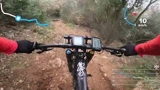
      Dh Torrelles
      mtb
      0:35 | 310 | Jan 19, 2025 , Gavá
      4.0 ★★★★★
      5 Ratings
      5 ★ 20%
      4 ★ 60%
      3 ★ 20%
      2 ★
      1 ★

      4 Reviews & Comments

      zepequeno zepequeno
      La bajada mayormente es roja, si, pero hay un paso a medi camino con unas piedras que hacen de escalones muy complicada, negra, y al final del trayecto, aunque tienes la pista forestal, si sigues la línea, hay un bajadón vertical que es una auténtica pared, solo para expertos con un par de... Creo que la etiqueta negra está justificada. Después de ese bajaron hay un salto doble y otro bajadón menos bestia, pero también vertical y estrecho.
      AntoniLo AntoniLo
      Me esperaba mucho más, la verdad que no la pondría en color negra, yo la he notado muy suave.

      We hope you've been enjoying Trailforks!

      Create a FREE account to view all trail reviews and much more.

      • By MAT7nueve & contributors
      • #44335 - 1,683 views

      Frequently Asked Questions

      ▼ Where is DH Torrelles located?
      DH Torrelles is located in Baix Llobregat Sud, Gavá, Spain. It is part of the Baix Llobregat Sud trail network. The trailhead is located at coordinates 41.35628, 1.99702.
      ▼ How hard is DH Torrelles?
      DH Torrelles is rated as Black difficulty. The physical rating is Moderate. The average grade is 23.4%.
      ▼ What is the elevation gain for DH Torrelles?
      The trail has 602 ft of elevation descent. The elevation ranges from 471 ft to 1,073 ft.
      ▼ Is DH Torrelles a point to point trail?
      Yes, DH Torrelles is a point to point trail. The direction is Downhill Only. The trail type is singletrack.
      ▼ How long is DH Torrelles?
      DH Torrelles is 2,569 ft long. The trail type is singletrack.
      ▼ Are dogs allowed on DH Torrelles?
      Yes, dogs are allowed on DH Torrelles. Please keep dogs on a leash where required and clean up after them.
      ▼ When is the best time of year to ride DH Torrelles?
      Based on activity log data, the most popular months to ride DH Torrelles are:
      • April (2 activities)
      • February (1 activities)
      • May (1 activities)
      Check the reports page for current trail conditions.
      ▼ How do I access DH Torrelles? Where is the closest parking trailhead?
      The closest parking and trailhead locations to DH Torrelles are: View all parking locations in the area.
      ▼ How long does it take to ride DH Torrelles?
      Based on recorded activities, it takes an average of 7 minutes to ride DH Torrelles. The trail is 2,569 ft long. Actual times will vary based on fitness level, conditions, and pace. View recent activity logs for more details.
      ▼ How busy is DH Torrelles?
      DH Torrelles is a less popular trail with lighter traffic. There have been 87 recorded activities on this trail. The trail has received 80 check-ins. View recent activity on this trail.

      Hit the Trail

      Open in App

      Get this trail on your phone instantly.

      open trail in app

      Download Trail

      Save to wishlist, Garmin & download.
      save the trail

      Find Related Routes

      Find routes and users activities that include this trail.
      find routes for this trail

      You must enter a description before submitting.

