more stats
1.7 miles
Distance
75 ft
Climb
-1,094 ft
Descent
00:10:39
Avg time
-1,019 ft
Altitude change
428 ft
Altitude min
1,456 ft
Altitude max
1,454 ft
Altitude start
436 ft
Altitude end
-11.5%
Grade
-57.7%
Grade max
13.7%
Grade min
1,171 ft
Distance climb
1 mile
Distance down
676 ft
Distance flat
00:10:39
Avg time

DH-Leone Details

  • Activities
    • Mountain Bike
    • E-Bike
  • Riding Area
    CelleLand
    Celle Ligure
  • Difficulty Rating
  • Voted Difficulty
    Red (5 votes)
  • Local Popularity
    100 in Mountain Biking [+]
    • 100 in E-Biking
  • Global Ranking
    #581 in Mountain Biking [+]
    • #1991 in E-Biking
  • Trail Type
    Singletrack
  • Bike Type
    DH, AM, XC, DJ
  • Climb Difficulty
    Black Diamond
  • Physical Rating
    Moderate
  • Trail Visibility
    Always easy to follow
  • Alpine Trail
    Yes
  • Family Friendly
    Yes
  • Dogs Allowed
    Yes
  • eBike Allowed
    Yes up to Class 1
  • TTFs on Trail
    A-Frame, Berm, Bridge, Drop, Jump, Gap Jump, Ladder Bridge, Log Ride, Pump Track, Rock Face, Rock Garden, Roller Coaster, Skinny, Teeter Totter, Wallride, Other
  • Land Owner
    civette-dh

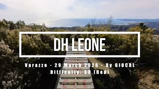
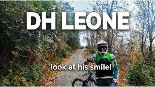
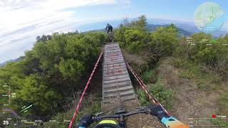
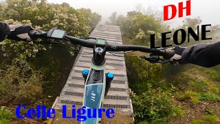
trail tecnico pieno di salti drop rock naturale dalla cima e durante il tracciato viste mozzafiato senza dimenticare il SALTO DEL LEONE che rimane in cima e da la sensazione di cadere in mare. un trail tecnico completo a CELLE LIGURE la seconda parte e stata rivista e semplificata moltissimo, disponibile la season 3 enjoy,
aggiunta la 4 parte per un pezzo totalmente flow e rollercoster da paura

Trail Supporters
Local Trail Association

Recent Activity on Trail

Past Week
  • 1 rides
  • 14 miles average
6 Months
  • 19 rides
  • 18 miles avg distance
All
  • 70 rides
  • Last: Jun 28, 2026
c1c2c3c4
January
February
March
April
May
June
July
August
September
October
November
December
update trails status or condition

DH-Leone Trail Reports

statusdatedescription
May 23, 2026 @ 8:35pm (Europe/Rome)
May 23, 2026
May 3, 2026 @ 10:16am (Europe/Rome)
May 3, 2026
Perfetto!! Molto asciutto ma decisamente ben tenuto. Percorso dall’inizio alla fine in tutte le sue 3 parti fino a celle
Apr 21, 2026 @ 8:43am (Europe/Rome)
Apr 20, 2026
Perfetto
Apr 20, 2026 @ 2:19pm (Europe/Rome)
Apr 20, 2026
Pulitissimo dall'inizio alla fine. Secco come se fosse agosto, attenzione al ripidone della parte 2, i freni vanno appena sfiorati, altrimenti si...
Apr 15, 2026 @ 12:50pm (Europe/Rome)
Apr 15, 2026
Perfetto, alcuni tratti molto asciutti e quindi impegnativi, ma sempre ok
more »
Status:
on May 23, 2026
Variable
Avg: 4.62 (13 votes)
Your vote: 0

view (701)
close
3D
Trail Conditions
  • Unknown
  • Snow Groomed
  • Snow Packed
  • Snow Covered
  • Snow Cover Partial
  • Freeze/thaw Cycle
  • Icy
  • Prevalent Mud
  • Wet
  • Variable
  • Ideal
  • Dry
  • Very Dry
Trail Flow (Ridden Direction)
Trailforks scans users ridelogs to determine the most popular direction each trail is ridden. A good flowing trail network will have most trails flowing in a single direction according to their intension.
The colour categories are based on what percentage of riders are riding a trail in its intended direction.
  • > 96%
  • > 90%
  • > 80%
  • > 70%
  • > 50%
  • < 50%
  • bi-directional trail
  • no data
Trail Last Ridden
Trailforks scans ridelogs to determine the last time a trail was ridden.
  • < 2 days
  • < 1 week
  • < 2 weeks
  • < 1 month
  • < 6 months
  • > 6 months
Trail Ridden Direction
The intended direction a trail should be ridden.
  • Downhill Only
  • Downhill Primary
  • Both Directions
  • Uphill Primary
  • Uphill Only
  • One Direction
Contribute Details
Colors indicate trail is missing specified detail.
  • Description
  • Photos
  • Description & Photos
  • Videos
Trail Popularity ?
Trailforks scans ridelogs to determine which trails are ridden the most in the last 9 months. Trails are compared with nearby trails in the same city region with a possible 25 colour shades. Think of this as a heatmap, more rides = more kinetic energy = warmer colors.
  • most popular
  • popular
  • less popular
  • not popular
ATV/ORV/OHV Filter
Max Vehicle Width
inches
US Cell Coverage
Legend
cell carrier legend

Radar Time
Activity Recordings
Trailforks uses anonymized public activity data. ?
Activity Recordings
Trailforks uses anonymized public activity data. ?
Personal Heatmap
Activity Types
all / none
Options
2
Date range month
Winter Trails
Warning A routing network for winter maps does not exist. Selecting trails using the winter trails layer has been disabled.
Missing Trails
Most Popular
Least Popular
Trails are colored based on popularity. The more popular a trail is, the more red. Less popular trails trend towards green.
Jump Magnitude Heatmap
Heatmap of where riders jump on trails. Zoom in to see individual jumps, click circles to view jump details.
BC Backroad Status

Service Road Atlas is a free to use, community-driven service for viewing and creating reports on the numerous back-country service roads around B.C. and Alberta.

map legend
Slope Aspect
Direction the slope faces
Flat N NE E SE S SW W NW
Trails Deemphasized
Trails are shown in grey.
disable
Only show trails with no bike usage.
Enable
Suggested Layers
Based on selected activity type

    Save the current map location and zoom level as your default home location whenever this page is loaded.

    Save
        Directions to dhleone trailhead (44.372840, 8.544440)

        Photos

        37 more »
        35 |
        Feb 14, 2026 @ 7:21am
        Feb 14, 2026
        47 |
        Jul 25, 2025 @ 10:59am
        Jul 25, 2025
        52 |
        May 2, 2025 @ 6:05am
        May 2, 2025
        51 |
        Apr 15, 2025 @ 7:24am
        Apr 15, 2025

        Videos

        5 more »
        Varazze eMTBing - Trail DH Leone (Super!)
        15:13 | 16 | Apr 29, 2026 , Celle Ligure
        DH Leone (Parte 1): Discesa Cattiva e salti...
        4:48 | 90 | Dec 28, 2025 , Celle Ligure
        Varazze - DH Leone
        4:52 | 79 | Sep 29, 2025 , Celle Ligure
        Dh leone wet
        8:19 | 260 | Apr 6, 2024 , Celle Ligure

        Trail Events

        17 Reviews & Comments


        We hope you've been enjoying Trailforks!

        Create a FREE account to view trail comments and much more.

        • By Matteo8989 & contributors
        • #619813 - 3,502 views

        Frequently Asked Questions About DH-Leone

        Where is DH-Leone located?
        DH-Leone is located in CelleLand, Celle Ligure, Italy. It is part of the CelleLand trail network. The trailhead is located at coordinates 44.37284, 8.54444.
        How hard is DH-Leone?
        DH-Leone is rated as Blue difficulty. The physical rating is Moderate. The average grade is 11.5%. The climb difficulty is rated Black Diamond.
        What is the elevation gain for DH-Leone?
        DH-Leone has 23 m of elevation gain. The trail has 333 m of elevation descent. The elevation ranges from 131 m to 444 m.
        How long is DH-Leone?
        DH-Leone is 2.7 km long. The trail type is singletrack.

        Hit the Trail

        Open in App

        Get this trail on your phone instantly.
        open trail in app

        Download Trail

        Save to wishlist, Garmin & download.
        save the trail

        Find Related Routes

        Find routes and users activities that include this trail.
        find routes for this trail

        You must enter a description before submitting.