more stats
2,831 ft
Distance
-148 ft
Descent
00:02:42
Avg time
-148 ft
Altitude change
2,067 ft
Altitude min
2,215 ft
Altitude max
2,215 ft
Altitude start
2,067 ft
Altitude end
-5.2%
Grade
-19.9%
Grade max
2,746 ft
Distance down
85 ft
Distance flat
00:02:42
Avg time

Double Dissolution Details

  • Activities
    • Mountain Bike
  • Riding Area
  • Difficulty Rating
  • Voted Difficulty
    Blue (2 votes)
  • Local Popularity
    85 in Mountain Biking
  • Global Ranking
    #339 in Mountain Biking
  • Trail Type
    Singletrack
  • Bike Type
    XC
  • Direction
    Downhill Only
    Popular Direction Shown
  • eBike Allowed
    Yes up to Class 1
  • Land Owner
    CMTEDD - National Arboretum Canberra/Stromlo Forest Park

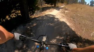
Double Dissolution - a political pun for a trail name. The trail has several double jumps on it that can be easily rolled if you don't like jumping. It tends to be quite worn due to the volume of traffic, but it also sees more maintenance than lesser used tracks. This is a fun one to push your personal limits for speed on.

Trail Supporters

Bike Park

Local Trail Association
Traditionally Indigenous Territory

Recent Activity on Trail

Past Week
  • 7 rides
  • 16 miles average
6 Months
  • 281 rides
  • 13 miles avg distance
All
  • 2,688 rides
  • Last: Jun 10, 2026
c1c2c3c4
January
February
March
April
May
June
July
August
September
October
November
December
Status:
on May 26, 2026
Wet
Avg: 4.16 (19 votes)
Your vote: 0

view (27,985)
close
3D
Trail Conditions
  • Unknown
  • Snow Groomed
  • Snow Packed
  • Snow Covered
  • Snow Cover Partial
  • Freeze/thaw Cycle
  • Icy
  • Prevalent Mud
  • Wet
  • Variable
  • Ideal
  • Dry
  • Very Dry
Trail Flow (Ridden Direction)
Trailforks scans users ridelogs to determine the most popular direction each trail is ridden. A good flowing trail network will have most trails flowing in a single direction according to their intension.
The colour categories are based on what percentage of riders are riding a trail in its intended direction.
  • > 96%
  • > 90%
  • > 80%
  • > 70%
  • > 50%
  • < 50%
  • bi-directional trail
  • no data
Trail Last Ridden
Trailforks scans ridelogs to determine the last time a trail was ridden.
  • < 2 days
  • < 1 week
  • < 2 weeks
  • < 1 month
  • < 6 months
  • > 6 months
Trail Ridden Direction
The intended direction a trail should be ridden.
  • Downhill Only
  • Downhill Primary
  • Both Directions
  • Uphill Primary
  • Uphill Only
  • One Direction
Contribute Details
Colors indicate trail is missing specified detail.
  • Description
  • Photos
  • Description & Photos
  • Videos
Trail Popularity ?
Trailforks scans ridelogs to determine which trails are ridden the most in the last 9 months. Trails are compared with nearby trails in the same city region with a possible 25 colour shades. Think of this as a heatmap, more rides = more kinetic energy = warmer colors.
  • most popular
  • popular
  • less popular
  • not popular
ATV/ORV/OHV Filter
Max Vehicle Width
inches
US Cell Coverage
Legend
cell carrier legend

Radar Time
Activity Recordings
Trailforks uses anonymized public activity data. ?
Activity Recordings
Trailforks uses anonymized public activity data. ?
Personal Heatmap
Activity Types
all / none
Options
2
Date range month
Winter Trails
Warning A routing network for winter maps does not exist. Selecting trails using the winter trails layer has been disabled.
Missing Trails
Most Popular
Least Popular
Trails are colored based on popularity. The more popular a trail is, the more red. Less popular trails trend towards green.
Jump Magnitude Heatmap
Heatmap of where riders jump on trails. Zoom in to see individual jumps, click circles to view jump details.
BC Backroad Status

Service Road Atlas is a free to use, community-driven service for viewing and creating reports on the numerous back-country service roads around B.C. and Alberta.

map legend
Slope Aspect
Direction the slope faces
Flat N NE E SE S SW W NW
Trails Deemphasized
Trails are shown in grey.
disable
Only show trails with no bike usage.
Enable
Suggested Layers
Based on selected activity type

    Save the current map location and zoom level as your default home location whenever this page is loaded.

    Save
        Directions to double-dissolution trailhead (-35.307190, 149.008480)

        Photos

        12 more »
        81 |
        Apr 20, 2022 @ 5:36pm
        Apr 20, 2022
        60 |
        Feb 15, 2021 @ 10:54pm
        Feb 15, 2021
        61 |
        Feb 15, 2021 @ 10:54pm
        Feb 15, 2021
        68 |
        Feb 15, 2021 @ 10:54pm
        Feb 15, 2021

        Videos

        8 more »
        Stromlo Forest - Double Dissolution (Blue)
        2:21 | 426 | Dec 5, 2021 , Canberra
        STROMLO MTB | Western Wedgetail → Pork...
        5:10 | 275 | Oct 21, 2020 , Canberra
        Cycling Belangalo and Mount Stromlo
        11:33 | 302 | Sep 23, 2020 , Canberra
        Stromlo - WW into Pork Barrel into Double...
        5:13 | 606 | Aug 18, 2019 , Canberra

        Routes with this trail

        5.0 50 miles 5,964 ft 39
        Mt Stromlo - Zoo Pines - Mt Majura - Bruce Ridge - Arboretum - Mt Stromlo(For beers)
        17 miles 2,501 ft 33
        Shimano 30 Course length 27km. Climbing 800m per lap. Approximately 75% of the trails in Stromlo used or...
        16 miles 2,225 ft 28
        Building a big loop to practice riding big loops

        1 Review & Comments


        We hope you've been enjoying Trailforks!

        Create a FREE account to view trail comments and much more.

        • By Jake-HannahTF Pro MPTA & contributors
        • #21279 - 3,457 views

        Frequently Asked Questions About Double Dissolution

        Where is Double Dissolution located?
        Double Dissolution is located in Stromlo Forest Park, Canberra, Australia. It is part of the Stromlo Forest Park trail network. The trailhead is located at coordinates -35.30719, 149.00848.
        How hard is Double Dissolution?
        Double Dissolution is rated as Blue difficulty. The average grade is 5.2%.
        What is the elevation gain for Double Dissolution?
        The trail has 148 ft of elevation descent. The elevation ranges from 2,067 ft to 2,215 ft.
        Is Double Dissolution a point to point trail?
        Yes, Double Dissolution is a point to point trail. The direction is Downhill Only. The trail type is singletrack.

        Hit the Trail

        Open in App

        Get this trail on your phone instantly.
        open trail in app

        Download Trail

        Save to wishlist, Garmin & download.
        save the trail

        Find Related Routes

        Find routes and users activities that include this trail.
        find routes for this trail

        You must enter a description before submitting.