more stats
827 ft
Distance
-111 ft
Descent
00:02:53
Avg time
-111 ft
Altitude change
763 ft
Altitude min
874 ft
Altitude max
874 ft
Altitude start
764 ft
Altitude end
-13.4%
Grade
-52.4%
Grade max
-0.7%
Grade min
781 ft
Distance down
49 ft
Distance flat
00:02:53
Avg time

Double Drap Details

  • Activities
    • Mountain Bike
    • E-Bike
  • Riding Area
    Scolty
    Banchory
  • Difficulty Rating
  • Local Popularity
    75 in Mountain Biking [+]
    • 90 in E-Biking
  • Global Ranking
    #65937 in Mountain Biking [+]
    • #26928 in E-Biking
  • Trail Type
    Singletrack
  • Bike Type
    DH, AM
  • Direction
    One Direction
  • Physical Rating
    Easy
  • Trail Visibility
    Always easy to follow
  • Season
    Rideable year round
  • eBike Allowed
    Yes up to Class 1
  • TTFs on Trail
    Drop, Jump
  • Ride in Rain
    Yes
  • Land Owner
    Forestry And Land Scotland

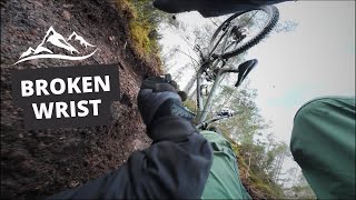
Nice easy wet weather friendly trail that links Top Section with some of the trails lower down the hill. Contains a couple of drops of various difficulty and a fairly small jump on the corner of the hill. All can be bypassed.

Access Info

Get to the top of Scolty hill and ride the Scolty DH Top Section (on the east side of the hill). The trail is the one furthest to the right, and always stays with a wall on it's right.

This trail is unsanctioned.

Recent Activity on Trail

Past Week
  • 1 rides
  • 4 miles average
6 Months
  • 10 rides
  • 8 miles avg distance
All
  • 75 rides
  • Last: Jun 27, 2026
c1c2c3c4
January
February
March
April
May
June
July
August
September
October
November
December
Status:
on Jun 12, 2026
Ideal
Avg: 3.89 (4 votes)
Your vote: 0

view (1,022)
close
3D
Trail Conditions
  • Unknown
  • Snow Groomed
  • Snow Packed
  • Snow Covered
  • Snow Cover Partial
  • Freeze/thaw Cycle
  • Icy
  • Prevalent Mud
  • Wet
  • Variable
  • Ideal
  • Dry
  • Very Dry
Trail Flow (Ridden Direction)
Trailforks scans users ridelogs to determine the most popular direction each trail is ridden. A good flowing trail network will have most trails flowing in a single direction according to their intension.
The colour categories are based on what percentage of riders are riding a trail in its intended direction.
  • > 96%
  • > 90%
  • > 80%
  • > 70%
  • > 50%
  • < 50%
  • bi-directional trail
  • no data
Trail Last Ridden
Trailforks scans ridelogs to determine the last time a trail was ridden.
  • < 2 days
  • < 1 week
  • < 2 weeks
  • < 1 month
  • < 6 months
  • > 6 months
Trail Ridden Direction
The intended direction a trail should be ridden.
  • Downhill Only
  • Downhill Primary
  • Both Directions
  • Uphill Primary
  • Uphill Only
  • One Direction
Contribute Details
Colors indicate trail is missing specified detail.
  • Description
  • Photos
  • Description & Photos
  • Videos
Trail Popularity ?
Trailforks scans ridelogs to determine which trails are ridden the most in the last 9 months. Trails are compared with nearby trails in the same city region with a possible 25 colour shades. Think of this as a heatmap, more rides = more kinetic energy = warmer colors.
  • most popular
  • popular
  • less popular
  • not popular
ATV/ORV/OHV Filter
Max Vehicle Width
inches
US Cell Coverage
Legend
cell carrier legend

Radar Time
Activity Recordings
Trailforks uses anonymized public activity data. ?
Activity Recordings
Trailforks uses anonymized public activity data. ?
Personal Heatmap
Activity Types
all / none
Options
2
Date range month
Winter Trails
Warning A routing network for winter maps does not exist. Selecting trails using the winter trails layer has been disabled.
Missing Trails
Most Popular
Least Popular
Trails are colored based on popularity. The more popular a trail is, the more red. Less popular trails trend towards green.
Jump Magnitude Heatmap
Heatmap of where riders jump on trails. Zoom in to see individual jumps, click circles to view jump details.
BC Backroad Status

Service Road Atlas is a free to use, community-driven service for viewing and creating reports on the numerous back-country service roads around B.C. and Alberta.

map legend
Slope Aspect
Direction the slope faces
Flat N NE E SE S SW W NW
Trails Deemphasized
Trails are shown in grey.
disable
Only show trails with no bike usage.
Enable
Suggested Layers
Based on selected activity type

    Save the current map location and zoom level as your default home location whenever this page is loaded.

    Save
        Directions to double-drap trailhead (57.035170, -2.527380)

        Photos

        2 more »
        218 |
        May 17, 2017 @ 9:33am
        May 17, 2017
        242 |
        May 17, 2017 @ 9:39am
        May 17, 2017

        Videos

        5 more »
        Big Crash in aberdeenshire.  Scolty still good...
        10:41 | 120 | Mar 8, 2024 , Banchory
        Connor Ogg // Sunny Daze
        0:42 | 4387 | May 21, 2017 , Banchory
        Scolty // New Bike
        3:25 | 577 | Jul 4, 2014 , Banchory
        Scolty Spring Shred
        0:23 | 1503 | May 6, 2016 , Banchory

        Routes with this trail

        5.0 14 miles 2,838 ft 65 Out & Back Race
        A route using lots of the trails route Scolty
        14 miles 2,838 ft 65 Out & Back Race
        A route using lots of the trails route Scolty

        Reviews / Comments

        No reviews yet, be the first to write a review or ask a question.
        Use trail reports to comment on trail conditions.


        We hope you've been enjoying Trailforks!

        Create a FREE account to view trail comments and much more.

        • #8117 - 2,261 views

        Frequently Asked Questions About Double Drap

        Where is Double Drap located?
        Double Drap is located in Scolty, Banchory, United Kingdom. It is part of the Scolty trail network. The trailhead is located at coordinates 57.03517, -2.52738.
        How hard is Double Drap?
        Double Drap is rated as Black difficulty. The physical rating is Easy. The average grade is 13.4%.
        What is the elevation gain for Double Drap?
        The trail has 111 ft of elevation descent. The elevation ranges from 763 ft to 874 ft.
        Is Double Drap a point to point trail?
        Yes, Double Drap is a point to point trail. The direction is One Direction. The trail type is singletrack.

        Hit the Trail

        Open in App

        Get this trail on your phone instantly.
        open trail in app

        Download Trail

        Save to wishlist, Garmin & download.
        save the trail

        Find Related Routes

        Find routes and users activities that include this trail.
        find routes for this trail

        You must enter a description before submitting.