more stats
1.8 miles
Distance
-1,381 ft
Descent
00:11:45
Avg time
-1,381 ft
Altitude change
6,363 ft
Altitude min
7,744 ft
Altitude max
7,744 ft
Altitude start
6,365 ft
Altitude end
-14.8%
Grade
-43%
Grade max
2 miles
Distance down
66 ft
Distance flat
00:11:45
Avg time

Double U Details

  • Activities
    • Mountain Bike
    • E-Bike
  • Riding Area
  • Difficulty Rating
  • Voted Difficulty
    Blue (1 vote)
  • Local Popularity
    80 in Mountain Biking [+]
    • 85 in E-Biking
  • Global Ranking
    #29030 in Mountain Biking [+]
    • #23355 in E-Biking
  • Trail Type
    Machine Groomed
  • Bike Type
    DH, AM
  • Direction
    Downhill Only
    Popular Direction Shown
  • Physical Rating
    Moderate
  • Trail Visibility
    Always easy to follow
  • eBike Allowed
    Yes up to Class 1
  • TTFs on Trail
    Berm, Drop, Jump, Gap Jump, Roller Coaster

DIRECTION
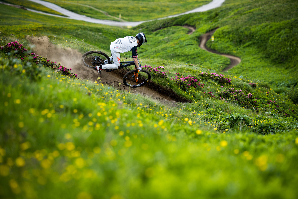
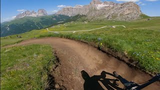
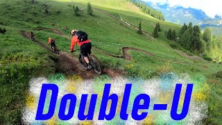
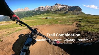
Trail that connects Col dei Rossi to Pecol (intermediate station of the lifts), through the Belvedere meadows.

DESCRIPTION
A fast flow-style trail with banked turns, bumps, switchbacks, and natural obstacles. It was the first line built in the Fassa Bike Park, named for the initial section which, originally seen from above, resembled a W.

 BorisBeyer

Access Info

Pecol - Col de Rossi Gondola

Bike Park

Recent Activity on Trail

Past Week
  • 3 rides
  • 34 miles average
6 Months
  • 3 rides
  • 34 miles avg distance
All
  • 289 rides
  • Last: Jun 16, 2026
c1c2c3c4
January
February
March
April
May
June
July
August
September
October
November
December
Status:
on Jun 19, 2026
Ideal
Avg: 4.16 (24 votes)
Your vote: 0

view (2,716)
close
3D
Trail Conditions
  • Unknown
  • Snow Groomed
  • Snow Packed
  • Snow Covered
  • Snow Cover Partial
  • Freeze/thaw Cycle
  • Icy
  • Prevalent Mud
  • Wet
  • Variable
  • Ideal
  • Dry
  • Very Dry
Trail Flow (Ridden Direction)
Trailforks scans users ridelogs to determine the most popular direction each trail is ridden. A good flowing trail network will have most trails flowing in a single direction according to their intension.
The colour categories are based on what percentage of riders are riding a trail in its intended direction.
  • > 96%
  • > 90%
  • > 80%
  • > 70%
  • > 50%
  • < 50%
  • bi-directional trail
  • no data
Trail Last Ridden
Trailforks scans ridelogs to determine the last time a trail was ridden.
  • < 2 days
  • < 1 week
  • < 2 weeks
  • < 1 month
  • < 6 months
  • > 6 months
Trail Ridden Direction
The intended direction a trail should be ridden.
  • Downhill Only
  • Downhill Primary
  • Both Directions
  • Uphill Primary
  • Uphill Only
  • One Direction
Contribute Details
Colors indicate trail is missing specified detail.
  • Description
  • Photos
  • Description & Photos
  • Videos
Trail Popularity ?
Trailforks scans ridelogs to determine which trails are ridden the most in the last 9 months. Trails are compared with nearby trails in the same city region with a possible 25 colour shades. Think of this as a heatmap, more rides = more kinetic energy = warmer colors.
  • most popular
  • popular
  • less popular
  • not popular
ATV/ORV/OHV Filter
Max Vehicle Width
inches
US Cell Coverage
Legend
cell carrier legend

Radar Time
Activity Recordings
Trailforks uses anonymized public activity data. ?
Activity Recordings
Trailforks uses anonymized public activity data. ?
Personal Heatmap
Activity Types
all / none
Options
2
Date range month
Winter Trails
Warning A routing network for winter maps does not exist. Selecting trails using the winter trails layer has been disabled.
Missing Trails
Most Popular
Least Popular
Trails are colored based on popularity. The more popular a trail is, the more red. Less popular trails trend towards green.
Jump Magnitude Heatmap
Heatmap of where riders jump on trails. Zoom in to see individual jumps, click circles to view jump details.
BC Backroad Status

Service Road Atlas is a free to use, community-driven service for viewing and creating reports on the numerous back-country service roads around B.C. and Alberta.

map legend
Slope Aspect
Direction the slope faces
Flat N NE E SE S SW W NW
Trails Deemphasized
Trails are shown in grey.
disable
Only show trails with no bike usage.
Enable
Suggested Layers
Based on selected activity type

    Save the current map location and zoom level as your default home location whenever this page is loaded.

    Save
        Directions to double-u trailhead (46.474800, 11.803400)

        Photos

        37 more »
        57 |
        Jul 22, 2025 @ 12:21am
        Jul 22, 2025
        82 |
        Aug 17, 2024 @ 8:48pm
        Aug 17, 2024
        191 |
        Mar 8, 2024 @ 2:59am
        Mar 8, 2024
        82 |
        Dec 28, 2023 @ 5:24am
        Dec 28, 2023

        Videos

        12 more »
        youtuber Double U - Fassa Bike District | Sellaronda...
        6:18 | 385 | Aug 20, 2023 , Canazei
        youtuber MTB Dolomiti Sellaronda 04.07.2021 sentiero...
        3:50 | 647 | Jul 9, 2021 , Canazei
        Trail combination of Double-U - Zacan -...
        9:09 | 84 | Jul 10, 2025 , Canazei
        Is Sella Ronda Bike Day REALLY Worth the Hype...
        1:0:31 | 65 | May 12, 2025 , Canazei

        Routes with this trail

        22 miles 9,659 ft 2
        Canazei IBA 2020 shortest flow
        29 miles 13,968 ft 6
        CANAZEI IBA 2020, with mechanical uphill
        27 miles 10,736 ft 4
        Canazei IBA 2020 Ossario Full day enduro

        3 Reviews & Comments


        We hope you've been enjoying Trailforks!

        Create a FREE account to view trail comments and much more.

        • By FranzRomano91 & contributors
        • #90103 - 4,161 views

        Frequently Asked Questions About Double U

        Where is Double U located?
        Double U is located in Fassa Bike District, Canazei, Italy. It is part of the Fassa Bike District trail network. The trailhead is located at coordinates 46.4748, 11.8034.
        How hard is Double U?
        Double U is rated as Blue difficulty. The physical rating is Moderate. The average grade is 14.8%.
        What is the elevation gain for Double U?
        The trail has 1,381 ft of elevation descent. The elevation ranges from 6,363 ft to 7,744 ft.
        Is Double U a point to point trail?
        Yes, Double U is a point to point trail. The direction is Downhill Only. The trail type is machine groomed.

        Hit the Trail

        Open in App

        Get this trail on your phone instantly.
        open trail in app

        Download Trail

        Save to wishlist, Garmin & download.
        save the trail

        Find Related Routes

        Find routes and users activities that include this trail.
        find routes for this trail

        You must enter a description before submitting.