more stats
5,066 ft
Distance
-686 ft
Descent
00:10:43
Avg time
-686 ft
Altitude change
4,499 ft
Altitude min
5,185 ft
Altitude max
5,185 ft
Altitude start
4,498 ft
Altitude end
-13.5%
Grade
-51.7%
Grade max
-1%
Grade min
5,066 ft
Distance down
00:10:43
Avg time

Down Time Details

  • Activities
    • Mountain Bike
    • E-Bike
    • Trail Running
  • Riding Area
    Bellevue
    , Alberta
  • Difficulty Rating
  • Local Popularity
    55 in Mountain Biking [+]
    • 5 in E-Biking
    • 25 in Trail Running
  • Global Ranking
    #86872 in Mountain Biking [+]
    • #127886 in Trail Running
  • Trail Type
    Singletrack
  • Bike Type
    AM
  • Direction
    Downhill Only
    Popular Direction Shown
  • Climb Difficulty
    Blue
  • Physical Rating
    Moderate
  • Trail Visibility
    Sometimes hard to follow
  • Season
    May to October
  • eBike Allowed
  • TTFs on Trail
    Berm, Drop, Rock Face, Rock Garden
  • Year Opened
    2019

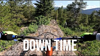
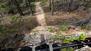
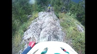
Down Time starts at the top of Good Riddance. It starts out steep, rocky, and tight through the trees. Look for signs on the way down as the trail crosses Good Riddance three times on the upper section. There are several large rock slabs on the lower section to enjoy. At the end of the trail, a short climb brings you back to the bottom of Lower Good Riddance.

Access Info

Use the climb up to Good Riddance.

This trail is unsanctioned.

Disclaimer

Trail is unsanctioned, use at own risk.

Recent Activity on Trail

Past Week
  • 0 rides
  •  
6 Months
  • 2 rides
  • 6 miles avg distance
All
  • 34 rides
  • Last: Jun 21, 2026
c1c2c3c4
January
February
March
April
May
June
July
August
September
October
November
December
update trails status or condition

Down Time Trail Reports

statusdatedescription
Apr 12, 2025 @ 12:57pm
Apr 12, 2025
mix of dry, icy, and knee deep snow. not ready yet
Sep 3, 2023 @ 6:56pm
Sep 3, 2023
a bit of rain damage in a few places but mostly good!
Oct 10, 2022 @ 9:33pm
Oct 10, 2022
reporter Trees are cleared, in great condition.
Aug 7, 2022 @ 8:10pm
Aug 7, 2022
There is a head high tree at the bottom of the steep section into the gully. Something to watch out for
Jun 13, 2022 @ 3:01pm
Jun 13, 2022
reporter excellent
more »
Status:
on Apr 12, 2025
Snow Cover Partial
Avg: 4.26 (5 votes)
Your vote: 0

view (189)
close
3D
Trail Conditions
  • Unknown
  • Snow Groomed
  • Snow Packed
  • Snow Covered
  • Snow Cover Partial
  • Freeze/thaw Cycle
  • Icy
  • Prevalent Mud
  • Wet
  • Variable
  • Ideal
  • Dry
  • Very Dry
Trail Flow (Ridden Direction)
Trailforks scans users ridelogs to determine the most popular direction each trail is ridden. A good flowing trail network will have most trails flowing in a single direction according to their intension.
The colour categories are based on what percentage of riders are riding a trail in its intended direction.
  • > 96%
  • > 90%
  • > 80%
  • > 70%
  • > 50%
  • < 50%
  • bi-directional trail
  • no data
Trail Last Ridden
Trailforks scans ridelogs to determine the last time a trail was ridden.
  • < 2 days
  • < 1 week
  • < 2 weeks
  • < 1 month
  • < 6 months
  • > 6 months
Trail Ridden Direction
The intended direction a trail should be ridden.
  • Downhill Only
  • Downhill Primary
  • Both Directions
  • Uphill Primary
  • Uphill Only
  • One Direction
Contribute Details
Colors indicate trail is missing specified detail.
  • Description
  • Photos
  • Description & Photos
  • Videos
Trail Popularity ?
Trailforks scans ridelogs to determine which trails are ridden the most in the last 9 months. Trails are compared with nearby trails in the same city region with a possible 25 colour shades. Think of this as a heatmap, more rides = more kinetic energy = warmer colors.
  • most popular
  • popular
  • less popular
  • not popular
ATV/ORV/OHV Filter
Max Vehicle Width
inches
US Cell Coverage
Legend
cell carrier legend

Radar Time
Activity Recordings
Trailforks uses anonymized public activity data. ?
Activity Recordings
Trailforks uses anonymized public activity data. ?
Personal Heatmap
Activity Types
all / none
Options
2
Date range month
Winter Trails
Warning A routing network for winter maps does not exist. Selecting trails using the winter trails layer has been disabled.
Missing Trails
Most Popular
Least Popular
Trails are colored based on popularity. The more popular a trail is, the more red. Less popular trails trend towards green.
Jump Magnitude Heatmap
Heatmap of where riders jump on trails. Zoom in to see individual jumps, click circles to view jump details.
BC Backroad Status

Service Road Atlas is a free to use, community-driven service for viewing and creating reports on the numerous back-country service roads around B.C. and Alberta.

map legend
Slope Aspect
Direction the slope faces
Flat N NE E SE S SW W NW
Trails Deemphasized
Trails are shown in grey.
disable
Only show trails with no bike usage.
Enable
Suggested Layers
Based on selected activity type

    Save the current map location and zoom level as your default home location whenever this page is loaded.

    Save
        Directions to down-time-263921 trailhead (49.601710, -114.362170)

        Photos

        7 more »
        57 |
        Aug 5, 2023 @ 3:52pm
        Aug 5, 2023
        66 |
        Aug 5, 2023 @ 3:50pm
        Aug 5, 2023
        57 |
        Aug 5, 2023 @ 3:41pm
        Aug 5, 2023
        247 |
        Jul 4, 2020 @ 3:57pm
        Jul 4, 2020

        Videos

        3 more »
        Technical Rock Slabs Downhill Trail - DOWN...
        8:24 | 57 | Oct 13, 2025 , Bellevue
        youtuber Down Time - An Old Crowsnest Trail Worth...
        7:27 | 403 | Jul 8, 2022 , Bellevue
        Down Time
        5:00 | 540 | Sep 14, 2019 , Bellevue

        4 Reviews & Comments


        We hope you've been enjoying Trailforks!

        Create a FREE account to view trail comments and much more.

        • #263921 - 2,029 views

        Frequently Asked Questions About Down Time

        Where is Down Time located?
        Down Time is located in Bellevue, Alberta, Canada. It is part of the Bellevue trail network. The trailhead is located at coordinates 49.60171, -114.36217.
        How hard is Down Time?
        Down Time is rated as Black Diamond difficulty. The physical rating is Moderate. The average grade is 13.5%. The climb difficulty is rated Blue.
        What is the elevation gain for Down Time?
        The trail has 686 ft of elevation descent. The elevation ranges from 4,499 ft to 5,185 ft.
        Is Down Time a point to point trail?
        Yes, Down Time is a point to point trail. The direction is Downhill Only. The trail type is singletrack.

        Hit the Trail

        Open in App

        Get this trail on your phone instantly.
        open trail in app

        Download Trail

        Save to wishlist, Garmin & download.
        save the trail

        Find Related Routes

        Find routes and users activities that include this trail.
        find routes for this trail

        You must enter a description before submitting.