



Open in App
Get this trail on your phone instantly.

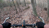
Nice bench cut trail with good flow. Lots of rollers, especially on the southern half. The north half of the trail is a little tougher, more overgrown, and has more rocks, but they are generally built into fun features.
Creek crossings and ditches are built up with rocks, but they seemed to have settled a bit so the entrance and exits can be a little steep and abrupt. These are likely the most treacherous portions of the trail.
No water sources along the trail, but there are three restrooms at mile 0, 4 and 16. Mileage markers start at the boat ramp on County Roads 1647 and go counterclockwise. The trail is marked as 19 miles, but GPS likes to come back as an 18 mile ride.
The trail is fun either direction, but around mile 19 (south of the dam) there is a good descent if you are going clockwise. There is a lower trail (unmapped) and an upper trail in this area.
| c1 | c2 | c3 | c4 |
|---|---|---|---|
January | February | March | April |
May | June | July | August |
September | October | November | December |

Service Road Atlas is a free to use, community-driven service for viewing and creating reports on the numerous back-country service roads around B.C. and Alberta.
Save the current map location and zoom level as your default home location whenever this page is loaded.
SaveWe hope you've been enjoying Trailforks!
Create a FREE account to view all trail reviews and much more.
 Trailforks Map Team & contributors
You must enter a description before submitting.

