This trail is planned
more stats
2,260 ft
Distance
-235 ft
Descent
00:11:46
Avg time
-235 ft
Altitude change
307 ft
Altitude min
541 ft
Altitude max
541 ft
Altitude start
308 ft
Altitude end
-10.4%
Grade
-44.7%
Grade max
-0.5%
Grade min
2,093 ft
Distance down
167 ft
Distance flat
00:11:46
Avg time

Dugite Bite Details

  • Activities
    • Mountain Bike
    • E-Bike
    • Hike
    • Trail Running
  • Riding Area
    Goat Farm
    Greenmount
  • Difficulty Rating
  • Voted Difficulty
    Black Diamond (1 vote)
  • Local Popularity
    5 in Mountain Biking [+]
    • 5 in E-Biking
    • 5 in Trail Running
    • 5 in Hiking
  • Trail Type
    Singletrack
  • Bike Type
    AM
  • Dogs Allowed
    Yes
  • eBike Allowed
    Yes up to Class 1

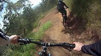
Launch from the “Slippery Nipple” into a long series of tight downhill berms before being spat out over a set of table tops and into more berms. Pass the spur trail A-Kline and into a wild rhythm section then down through some deep berms before being launched into orbit on the final table top. Continue on and join the Blue Cruiser trail back to the car park or push your way back up to the top via the push up trail.

Planned as a "community build" realignment as part of the last major Goat Farm developments.

Local Trail Association
Traditionally Indigenous Territory

Recent Activity on Trail

Past Week
  • 0 rides
  •  
6 Months
  • 0 rides
  •  
All
  • 66 rides
  • Last: Jul 17, 2021
c1c2c3c4
January
February
March
April
May
June
July
August
September
October
November
December
update trails status or condition

Dugite Bite Trail Reports

statusdatedescription
Mar 14, 2021 @ 8:11pm
Mar 14, 2021
Extremely rutted from water run off, overgrown by weeds and jumps eroded.
Dec 27, 2020 @ 1:28pm
Dec 27, 2020
Course poorly marked, and needs a bit of love.
Nov 10, 2020 @ 10:29pm
Nov 10, 2020
Sep 19, 2020 @ 10:13pm
Sep 19, 2020
These trails are very run down. Shame on the locals for letting this place fall into such disrepair. Terrible signage around the trails.
Mar 25, 2020 @ 8:54pm
Mar 25, 2020
Some berms have drainage issues and ruts are forming on straights
more »
Status:
on Mar 14, 2021
Dry
Avg: 4.38 (7 votes)
Your vote: 0

view (829)
close
3D
Trail Conditions
  • Unknown
  • Snow Groomed
  • Snow Packed
  • Snow Covered
  • Snow Cover Partial
  • Freeze/thaw Cycle
  • Icy
  • Prevalent Mud
  • Wet
  • Variable
  • Ideal
  • Dry
  • Very Dry
Trail Flow (Ridden Direction)
Trailforks scans users ridelogs to determine the most popular direction each trail is ridden. A good flowing trail network will have most trails flowing in a single direction according to their intension.
The colour categories are based on what percentage of riders are riding a trail in its intended direction.
  • > 96%
  • > 90%
  • > 80%
  • > 70%
  • > 50%
  • < 50%
  • bi-directional trail
  • no data
Trail Last Ridden
Trailforks scans ridelogs to determine the last time a trail was ridden.
  • < 2 days
  • < 1 week
  • < 2 weeks
  • < 1 month
  • < 6 months
  • > 6 months
Trail Ridden Direction
The intended direction a trail should be ridden.
  • Downhill Only
  • Downhill Primary
  • Both Directions
  • Uphill Primary
  • Uphill Only
  • One Direction
Contribute Details
Colors indicate trail is missing specified detail.
  • Description
  • Photos
  • Description & Photos
  • Videos
Trail Popularity ?
Trailforks scans ridelogs to determine which trails are ridden the most in the last 9 months. Trails are compared with nearby trails in the same city region with a possible 25 colour shades. Think of this as a heatmap, more rides = more kinetic energy = warmer colors.
  • most popular
  • popular
  • less popular
  • not popular
ATV/ORV/OHV Filter
Max Vehicle Width
inches
US Cell Coverage
Legend
cell carrier legend

Radar Time
Activity Recordings
Trailforks uses anonymized public activity data. ?
Activity Recordings
Trailforks uses anonymized public activity data. ?
Personal Heatmap
Activity Types
all / none
Options
2
Date range month
Winter Trails
Warning A routing network for winter maps does not exist. Selecting trails using the winter trails layer has been disabled.
Missing Trails
Most Popular
Least Popular
Trails are colored based on popularity. The more popular a trail is, the more red. Less popular trails trend towards green.
Jump Magnitude Heatmap
Heatmap of where riders jump on trails. Zoom in to see individual jumps, click circles to view jump details.
BC Backroad Status

Service Road Atlas is a free to use, community-driven service for viewing and creating reports on the numerous back-country service roads around B.C. and Alberta.

map legend
Slope Aspect
Direction the slope faces
Flat N NE E SE S SW W NW
Trails Deemphasized
Trails are shown in grey.
disable
Only show trails with no bike usage.
Enable
Suggested Layers
Based on selected activity type

    Save the current map location and zoom level as your default home location whenever this page is loaded.

    Save
        Directions to dugite-bite trailhead (-31.906830, 116.055480)

        Photos

        16 more »
        35 |
        Jul 5, 2021 @ 2:47am
        Jul 5, 2021
        134 |
        Sep 5, 2020 @ 7:59am
        Sep 5, 2020
        75 |
        Jun 19, 2020 @ 4:47pm
        Jun 19, 2020
        97 |
        Apr 19, 2020 @ 3:21pm
        Apr 19, 2020

        Videos

        10 more »
        WA Goat Farm Mountain Bike Park 4k
        0:21 | 308 | Jan 4, 2020 , Greenmount
        Derailleur Fun Times
        644 | Jun 26, 2015 , Greenmount
        Dans Crash - Dual Broken Elbows
        0:21 | 256 | Jul 18, 2020 , Greenmount
        Something Chill | Goat Farm
        2:25 | 417 | Jul 1, 2020 , Greenmount

        Reviews / Comments

        No reviews yet, be the first to write a review or ask a question.
        Use trail reports to comment on trail conditions.


        We hope you've been enjoying Trailforks!

        Create a FREE account to view trail comments and much more.

        • By Jake-HannahTF Pro MPTA & contributors
        • #19537 - 2,362 views

        Hit the Trail

        Open in App

        Get this trail on your phone instantly.
        open trail in app

        Download Trail

        Save to wishlist, Garmin & download.
        save the trail

        Find Related Routes

        Find routes and users activities that include this trail.
        find routes for this trail

        You must enter a description before submitting.