


more stats
2.0 miles
Distance
373 ft
Climb
-362 ft
Descent
00:23:02
Avg time
11 ft
Altitude change
3,764 ft
Altitude min
3,993 ft
Altitude max
3,764 ft
Altitude start
3,776 ft
Altitude end
0.104%
Grade
-21.723%
Grade max
22.655%
Grade min
5,172 ft
Distance climb
4,691 ft
Distance down
858 ft
Distance flat
00:23:02
Avg time

Dynamite Details

  • Activities
    • Mountain Bike
    • Winter Fat Bike
    • Hike
    • Trail Running
  • Riding Area
    Spicer Ranch
    Beatty, Nevada
  • Difficulty Rating
  • Local Popularity
    95 in Mountain Biking [+]
    • 100 in Trail Running
    • 5 in Hiking
    • 5 in Winter Fat Biking
  • Global Ranking
    #45782 in Mountain Biking [+]
    • #85015 in Trail Running
    • #327842 in Hiking
    • #7417 in Winter Fat Biking
  • State Ranking
    #209 in Mountain Biking · Nevada [+]
    • #433 in Trail Running
    • #1,379 in Hiking
    • #23 in Winter Fat Biking
  • Hiking SAC Scale
    T2 Mountain Hiking
  • Trail Type
    Singletrack
  • Bike Type
    AM, XC, Fat
  • Direction
    Both Directions
  • Climb Difficulty
    Black Diamond
  • Physical Rating
    Hard
  • Dogs Allowed
    Yes
  • Year Opened
    2015

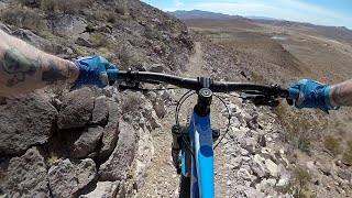
A 1 mile enjoyable climb with some switchbacks followed by a 1 mile fun downhill.

Tags

Local Trail Association

Traditionally Indigenous Territory

Recent Activity on Trail

Past Week
  • 0 rides
  •  
6 Months
  • 2 rides
  • 12 miles avg distance
All
  • 34 rides
  • Last: Sep 29, 2026
update trails status or condition

Dynamite Trail Reports

statusdatedescription
Nov 23, 2024 @ 11:41am
Nov 23, 2024
Still in good shape, but not as clean as last time. A great, fun ride!
Apr 30, 2024 @ 7:56am
Apr 30, 2024
Incredibly fun trail! Thanks for the great engineering and build! I don't normally ride rock gardens and especially black diamond ones, but this...
Mar 22, 2023 @ 2:11am
Mar 22, 2023
Oct 28, 2022 @ 4:49pm
Oct 28, 2022
Nov 22, 2020 @ 9:16am
Nov 22, 2020
My Favorite trail at Trails Oasis.
more »
Status:
on Nov 23, 2024
Dry
Avg: 4.06 (9 votes)
Your vote: 0

view (263)
close
      Directions to dynamite-29674 trailhead (36.998600, -116.711010)

      Photos

      25 more »
      mtb
      86 |
      Mar 11, 2023 @ 11:13pm
      Mar 11, 2023
      mtb
      91 |
      Mar 11, 2023 @ 11:13pm
      Mar 11, 2023
      mtb
      50 |
      Mar 11, 2023 @ 11:12pm
      Mar 11, 2023
      mtb
      57 |
      Mar 11, 2023 @ 11:12pm
      Mar 11, 2023

      Videos

      2 more »
      'Dynamite Trail' @ Spicer Ranch 3-17-21
      mtb
      0:55 | 601 | Mar 27, 2021 , Beatty
      Mountain Biking Spicer Ranch! | Part One |...
      mtb
      7:07 | 1880 | Jun 6, 2019 , Beatty
      4.2 ★★★★★
      9 Ratings
      5 ★ 56%
      4 ★ 22%
      3 ★ 11%
      2 ★ 11%
      1 ★

      5 Reviews & Comments

      RocklinDave
      Incredibly fun trail! Thanks for the great engineering and build! I don't normally ride rock gardens and especially black diamond ones, but this was quite difficult without lots of rocks.
      akanatron akanatron
      Fun little loop around a rocky hill. Not overly technical but with a bit of exposure the black rating seems warranted. We rode it both directions and preferred it clockwise, a little steeper climbing with uphill swtchbacks and a bit better flow downhill. That said, both directions were good.
      matux matux
      Great trail! Personally I would ride it counter clockwise next time. The NW side is slower as a DH in my opinion because it’s more twisty, exposed and full of huge derailleur basher rocks (most are on the immediate side of trail). I think I would enjoy weaving through all the NW rocks more as an uphill, but as a downhill it is fun to dodge them and get surprised by all the sharp cliff corners, just slower.

      No drops, minimal rocks in the trail, 100’s of rocks to dodge (that wouldn’t roll well).

      We hope you've been enjoying Trailforks!

      Create a FREE account to view all trail reviews and much more.

      • By schillingsworthTF Pro TRAILFORKS HTA & contributors
      • #29674 - 2,483 views

      Frequently Asked Questions

      ▼ Where is Dynamite located?
      Dynamite is located in Spicer Ranch, Beatty, Nevada, United States. It is part of the Spicer Ranch trail network. The trailhead is located at coordinates 36.9986, -116.71101.
      ▼ How hard is Dynamite?
      Dynamite is rated as Black Diamond difficulty. The physical rating is Hard. The average grade is 0.104%. The climb difficulty is rated Black Diamond.
      ▼ What is the elevation gain for Dynamite?
      Dynamite has 373 ft of elevation gain. The trail has 362 ft of elevation descent. The elevation ranges from 3,764 ft to 3,993 ft.
      ▼ Is Dynamite a point to point trail?
      Dynamite is not a point to point trail. The direction is Both Directions. The trail type is singletrack.
      ▼ How long is Dynamite?
      Dynamite is 2.0 miles long. The trail type is singletrack.
      ▼ Are dogs allowed on Dynamite?
      Yes, dogs are allowed on Dynamite. Please keep dogs on a leash where required and clean up after them.
      ▼ How long does it take to ride Dynamite?
      Based on recorded activities, it takes an average of 23 minutes to ride Dynamite. The trail is 2.0 miles long. Actual times will vary based on fitness level, conditions, and pace. View recent activity logs for more details.
      ▼ How busy is Dynamite?
      Dynamite is a very popular trail. There have been 148 recorded activities on this trail. The trail has received 263 check-ins. View recent activity on this trail.

      Hit the Trail

      Open in App

      Get this trail on your phone instantly.

      open trail in app

      Download Trail

      Save to wishlist, Garmin & download.
      save the trail

      Find Related Routes

      Find routes and users activities that include this trail.
      find routes for this trail

      You must enter a description before submitting.