more stats
1.5 miles
Distance
2 ft
Climb
-748 ft
Descent
00:06:47
Avg time
-745 ft
Altitude change
6,376 ft
Altitude min
7,122 ft
Altitude max
7,122 ft
Altitude start
6,378 ft
Altitude end
-9.5%
Grade
-58.4%
Grade max
5.4%
Grade min
108 ft
Distance climb
1 mile
Distance down
466 ft
Distance flat
00:06:47
Avg time

Eebme Line Details

  • Activities
    • Mountain Bike
    • E-Bike
  • Riding Area
  • Ref Number
    #6005
  • Difficulty Rating
  • Voted Difficulty
    Blue (5 votes)
  • Local Popularity
    95 in Mountain Biking [+]
    • 90 in E-Biking
  • Global Ranking
    #1800 in Mountain Biking [+]
    • #14911 in E-Biking
  • Trail Type
    Machine Groomed
  • Bike Type
    DH, AM
  • Physical Rating
    Easy
  • Season
    Jun - Oct
  • Dogs Allowed
    Yes
  • eBike Allowed
  • TTFs on Trail
    Berm
  • Year Opened
    2016

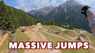
Probably the most flowy trail: "Eebme Line" - open from 18.06.2016 - is one of this season's new attractions of the Bike Republic Starting close to the Gaislachkogl Middle Station, it makes a perfect training area right amidst the huge network of trails. An ideal warm-up route which is almost level but not too flat. Beginners and novice bikers are recommended to practice the right flow on this trail before they try the other, more demanding routes.

Access Info

The "Eebme Line" starts close to the Gaislachkogel middle station

Bike Park

Recent Activity on Trail

Past Week
  • 0 rides
  •  
6 Months
  • 0 rides
  •  
All
  • 738 rides
  • Last: Jul 29, 2025
c1c2c3c4
January
February
March
April
May
June
July
August
September
October
November
December
update trails status or condition

Eebme Line Trail Reports

statusdatedescription
Jan 10, 2026 @ 9:28am (Europe/Vienna)
Jan 10, 2026
Closed, Winterbetrieb bzw. Wintersperre. Vrsl. Öffnung der Bikepark-Saison 2026: 4. - 7. Juni 2026 (Pre-Opening)
Sep 18, 2025 @ 9:38am (Europe/Vaduz)
Sep 18, 2025
Aug 9, 2025 @ 9:02am
Aug 9, 2025
Aug 6, 2025 @ 1:00pm
Aug 6, 2025
Aug 5, 2025 @ 1:00pm
Aug 5, 2025
Minor section closed for rebuild , fair amount of brake bumps it’s the toll for 2 weeks of rain …
more »
Status:
on Jan 10, 2026
Avg: 4.06 (49 votes)
Your vote: 0

view (7,004)
close
3D
Trail Conditions
  • Unknown
  • Snow Groomed
  • Snow Packed
  • Snow Covered
  • Snow Cover Partial
  • Freeze/thaw Cycle
  • Icy
  • Prevalent Mud
  • Wet
  • Variable
  • Ideal
  • Dry
  • Very Dry
Trail Flow (Ridden Direction)
Trailforks scans users ridelogs to determine the most popular direction each trail is ridden. A good flowing trail network will have most trails flowing in a single direction according to their intension.
The colour categories are based on what percentage of riders are riding a trail in its intended direction.
  • > 96%
  • > 90%
  • > 80%
  • > 70%
  • > 50%
  • < 50%
  • bi-directional trail
  • no data
Trail Last Ridden
Trailforks scans ridelogs to determine the last time a trail was ridden.
  • < 2 days
  • < 1 week
  • < 2 weeks
  • < 1 month
  • < 6 months
  • > 6 months
Trail Ridden Direction
The intended direction a trail should be ridden.
  • Downhill Only
  • Downhill Primary
  • Both Directions
  • Uphill Primary
  • Uphill Only
  • One Direction
Contribute Details
Colors indicate trail is missing specified detail.
  • Description
  • Photos
  • Description & Photos
  • Videos
Trail Popularity ?
Trailforks scans ridelogs to determine which trails are ridden the most in the last 9 months. Trails are compared with nearby trails in the same city region with a possible 25 colour shades. Think of this as a heatmap, more rides = more kinetic energy = warmer colors.
  • most popular
  • popular
  • less popular
  • not popular
ATV/ORV/OHV Filter
Max Vehicle Width
inches
US Cell Coverage
Legend
cell carrier legend

Radar Time
Activity Recordings
Trailforks uses anonymized public activity data. ?
Activity Recordings
Trailforks uses anonymized public activity data. ?
Personal Heatmap
Activity Types
all / none
Options
2
Date range month
Winter Trails
Warning A routing network for winter maps does not exist. Selecting trails using the winter trails layer has been disabled.
Missing Trails
Most Popular
Least Popular
Trails are colored based on popularity. The more popular a trail is, the more red. Less popular trails trend towards green.
Jump Magnitude Heatmap
Heatmap of where riders jump on trails. Zoom in to see individual jumps, click circles to view jump details.
BC Backroad Status

Service Road Atlas is a free to use, community-driven service for viewing and creating reports on the numerous back-country service roads around B.C. and Alberta.

map legend
Slope Aspect
Direction the slope faces
Flat N NE E SE S SW W NW
Trails Deemphasized
Trails are shown in grey.
disable
Only show trails with no bike usage.
Enable
Suggested Layers
Based on selected activity type

    Save the current map location and zoom level as your default home location whenever this page is loaded.

    Save
        Directions to eebme-line trailhead (46.951600, 10.987000)

        Photos

        10 more »
        299 |
        Aug 21, 2016 @ 3:20am
        Aug 21, 2016
        242 |
        Jun 16, 2016 @ 12:32am
        Jun 16, 2016
        283 |
        Jun 16, 2016 @ 12:32am
        Jun 16, 2016
        242 |
        Jun 16, 2016 @ 12:31am
        Jun 16, 2016

        Videos

        7 more »
        youtuber Eebme Line - Bike Republic Sölden
        3:46 | 247 | Aug 31, 2022 , Sölden
        LONGEST FLOW TRAILS & MASSIVE JUMPS - FULL...
        20:47 | 13 | Dec 7, 2025 , Sölden
        Eebme Line - Bike Republic Sölden
        6:21 | 65 | Oct 22, 2024 , Sölden
        Tour de Sölden, The Bike Republic of Austrian...
        25:06 | 152 | Sep 10, 2022 , Sölden

        Reviews / Comments

        No reviews yet, be the first to write a review or ask a question.
        Use trail reports to comment on trail conditions.


        We hope you've been enjoying Trailforks!

        Create a FREE account to view trail comments and much more.

        Nearby Trails

        • By BikeRepublicSoelden & contributors
        • #59984 - 2,929 views

        Frequently Asked Questions About Eebme Line

        Where is Eebme Line located?
        Eebme Line is located in Bike Republic Sölden, Sölden, Austria. It is part of the Bike Republic Sölden trail network. The trailhead is located at coordinates 46.9516, 10.987.
        How hard is Eebme Line?
        Eebme Line is rated as Blue difficulty. The physical rating is Easy. The average grade is 9.5%.
        What is the elevation gain for Eebme Line?
        Eebme Line has 1 m of elevation gain. The trail has 228 m of elevation descent. The elevation ranges from 1,944 m to 2,171 m.
        How long is Eebme Line?
        Eebme Line is 2.4 km long. The trail type is machine groomed.

        Hit the Trail

        Open in App

        Get this trail on your phone instantly.
        open trail in app

        Download Trail

        Save to wishlist, Garmin & download.
        save the trail

        Find Related Routes

        Find routes and users activities that include this trail.
        find routes for this trail

        You must enter a description before submitting.