more stats
1.4 miles
Distance
272 ft
Climb
-314 ft
Descent
00:20:21
Avg time
-42 ft
Altitude change
325 ft
Altitude min
601 ft
Altitude max
599 ft
Altitude start
558 ft
Altitude end
-0.6%
Grade
-39.1%
Grade max
23.4%
Grade min
4,436 ft
Distance climb
2,844 ft
Distance down
217 ft
Distance flat
00:20:21
Avg time

Enchanted Loop Details

  • Activities
    • Mountain Bike
    • E-Bike
    • Horse
    • Hike
    • Trail Running
  • Riding Area
    Wilder Ranch
    Santa Cruz, California
  • Difficulty Rating
  • Voted Difficulty
    Black Diamond (10 votes)
  • Local Popularity
    80 in Mountain Biking [+]
    • 85 in E-Biking
    • 65 in Trail Running
    • 90 in Hiking
    • 5 in Horseback
  • Global Ranking
    #22696 in Mountain Biking [+]
    • #3353 in E-Biking
    • #36163 in Trail Running
    • #1472 in Hiking
    • #869 in Horseback
  • Hiking SAC Scale
    T2 Mountain Hiking
  • Trail Type
    Singletrack
  • Bike Type
    AM, XC
  • Direction
    Downhill Primary
    Popular Direction Shown
  • Climb Difficulty
    Double Black Diamond
  • Physical Rating
    Hard
  • Trail Visibility
    Always easy to follow
  • Dogs Allowed
    Yes
  • eBike Allowed
    Yes up to Class 1
  • TTFs on Trail
    Drop
  • Land Owner
    California State Parks

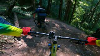
Ride Clockwise for a fun, root strewn descent (drop in on the southern end, closer to the coast) Plenty of opportunities to boost over roots, but you can roll them too. Watch for the drop-off/switchback. Climb out was rerouted in 2016 with a pleasant gradient.

Traditionally Indigenous Territory

Recent Activity on Trail

Past Week
  • 7 rides
  • 14 miles average
6 Months
  • 111 rides
  • 18 miles avg distance
All
  • 1,233 rides
  • Last: Jun 20, 2026
c1c2c3c4
January
February
March
April
May
June
July
August
September
October
November
December
update trails status or condition

Enchanted Loop Trail Reports

statusdatedescription
Mar 17, 2026 @ 2:33pm (America/Los_Angeles)
Mar 17, 2026
reporter Fallen tree has been removed
Mar 13, 2026 @ 7:32pm (America/Los_Angeles)
Mar 13, 2026
Larger tree Needing chainsaw. Kind soon as a new braid is forming around it. See picture
Mar 7, 2026 @ 10:38am (America/Los_Angeles)
Mar 7, 2026
Large tree down across the trail on the climb out
Jan 11, 2026 @ 11:47am (America/Los_Angeles)
Jan 11, 2026
Dec 9, 2025 @ 12:12pm (America/Los_Angeles)
Dec 9, 2025
more »
Status:
on Mar 17, 2026
Dry
Avg: 4.32 (54 votes)
Your vote: 0

view (8,123)
close
3D
Trail Conditions
  • Unknown
  • Snow Groomed
  • Snow Packed
  • Snow Covered
  • Snow Cover Partial
  • Freeze/thaw Cycle
  • Icy
  • Prevalent Mud
  • Wet
  • Variable
  • Ideal
  • Dry
  • Very Dry
Trail Flow (Ridden Direction)
Trailforks scans users ridelogs to determine the most popular direction each trail is ridden. A good flowing trail network will have most trails flowing in a single direction according to their intension.
The colour categories are based on what percentage of riders are riding a trail in its intended direction.
  • > 96%
  • > 90%
  • > 80%
  • > 70%
  • > 50%
  • < 50%
  • bi-directional trail
  • no data
Trail Last Ridden
Trailforks scans ridelogs to determine the last time a trail was ridden.
  • < 2 days
  • < 1 week
  • < 2 weeks
  • < 1 month
  • < 6 months
  • > 6 months
Trail Ridden Direction
The intended direction a trail should be ridden.
  • Downhill Only
  • Downhill Primary
  • Both Directions
  • Uphill Primary
  • Uphill Only
  • One Direction
Contribute Details
Colors indicate trail is missing specified detail.
  • Description
  • Photos
  • Description & Photos
  • Videos
Trail Popularity ?
Trailforks scans ridelogs to determine which trails are ridden the most in the last 9 months. Trails are compared with nearby trails in the same city region with a possible 25 colour shades. Think of this as a heatmap, more rides = more kinetic energy = warmer colors.
  • most popular
  • popular
  • less popular
  • not popular
ATV/ORV/OHV Filter
Max Vehicle Width
inches
US Cell Coverage
Legend
cell carrier legend

Radar Time
Activity Recordings
Trailforks uses anonymized public activity data. ?
Activity Recordings
Trailforks uses anonymized public activity data. ?
Personal Heatmap
Activity Types
all / none
Options
2
Date range month
Winter Trails
Warning A routing network for winter maps does not exist. Selecting trails using the winter trails layer has been disabled.
Missing Trails
Most Popular
Least Popular
Trails are colored based on popularity. The more popular a trail is, the more red. Less popular trails trend towards green.
Jump Magnitude Heatmap
Heatmap of where riders jump on trails. Zoom in to see individual jumps, click circles to view jump details.
BC Backroad Status

Service Road Atlas is a free to use, community-driven service for viewing and creating reports on the numerous back-country service roads around B.C. and Alberta.

map legend
Slope Aspect
Direction the slope faces
Flat N NE E SE S SW W NW
Trails Deemphasized
Trails are shown in grey.
disable
Only show trails with no bike usage.
Enable
Suggested Layers
Based on selected activity type

    Save the current map location and zoom level as your default home location whenever this page is loaded.

    Save
        Directions to enchanted-loop trailhead (36.986110, -122.110180)

        Photos

        56 more »
        116 |
        Nov 27, 2025 @ 10:53pm
        Nov 27, 2025
        130 |
        Nov 27, 2025 @ 10:53pm
        Nov 27, 2025
        330 |
        Jul 29, 2024 @ 3:08pm
        Jul 29, 2024
        231 |
        Sep 27, 2023 @ 10:48am
        Sep 27, 2023

        Videos

        12 more »
        Mountain Biking Wilder Ranch at Santa Cruz
        14:25 | 177 | Aug 5, 2025 , Santa Cruz
        youtuber Enchanted
        17:01 | 501 | Jan 2, 2025 , Santa Cruz
        youtuber Wilder Ranch E-Bike Test: Santa Cruz Heckler...
        6:58 | 446 | May 13, 2024 , Santa Cruz
        Wilder Enchanted Loop
        3:05 | 496 | Oct 30, 2023 , Santa Cruz

        Trail Lists

        Routes with this trail

        3.9 10 miles 1,234 ft 8
        Update loop with new Englseman trail (thanks MBoSC!)
        4.3 21 miles 1,945 ft 10
        This loop incorporates the best of Wilder Ranch. The only thing to note is the is ridden clockwise NOT...
        5.0 21 miles 1,943 ft 12
        This loop incorporates the best of . The only thing to note is the is ridden clockwise NOT...

        17 Reviews & Comments


        We hope you've been enjoying Trailforks!

        Create a FREE account to view trail comments and much more.

        Frequently Asked Questions About Enchanted Loop

        Where is Enchanted Loop located?
        Enchanted Loop is located in Wilder Ranch, Santa Cruz, California, United States. It is part of the Wilder Ranch trail network. The trailhead is located at coordinates 36.98611, -122.11018.
        How hard is Enchanted Loop?
        Enchanted Loop is rated as Black Diamond difficulty. The physical rating is Hard. The average grade is 0.6%. The climb difficulty is rated Double Black Diamond.
        What is the elevation gain for Enchanted Loop?
        Enchanted Loop has 83 m of elevation gain. The trail has 96 m of elevation descent. The elevation ranges from 99 m to 183 m.
        Is Enchanted Loop a point to point trail?
        Enchanted Loop is not a point to point trail. The direction is Downhill Primary. The trail type is singletrack.

        Hit the Trail

        Open in App

        Get this trail on your phone instantly.
        open trail in app

        Download Trail

        Save to wishlist, Garmin & download.
        save the trail

        Find Related Routes

        Find routes and users activities that include this trail.
        find routes for this trail

        You must enter a description before submitting.