3,940 ft
Distance
5 ft
Climb
-427 ft
Descent
00:04:26
Avg time

End Game Details

  • Activities
    • Mountain Bike
    • E-Bike
  • Riding Area
    Revelstoke Mountain Resort
    Revelstoke, British Columbia
  • AKA
    Endgame
  • Difficulty Rating
  • Trail Type
    Singletrack
  • Bike Type
    DH, AM
  • Direction
    Downhill Only
    Popular direction shown
  • Physical Rating
    Moderate
  • Trail Visibility
    Always easy to follow
  • Season
    Summer
  • eBike Allowed
    Yes up to Class 1
  • TTFs on Trail
    Berm, Drop, Jump, Gap Jump
  • Global Ranking
    #40439 in Mountain Biking
  • Local Popularity
    95 in Mountain Biking [+]
    • 80 in E-Biking
  • Year Opened
    2021
  • Land Owner
    Revelstoke Mountain Resort

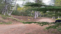
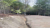
A fast, flowy jump trail to finish off your lap. Optional dirt jumps halfway down with a trail to push back up and session. Significant additions for 2022. Jumps may be harder to clear during wet weather. Look before you leap. Please do not walk all over the features while scoping it out.

Access Info

Access End Game from Fifty Six Twenty, well below the gondola mid-station

Bike Park

More Stats for End Game mountain bike trail trail
  • Altitude change
    -422 ft
  • Altitude min
    1,706 ft
  • Altitude max
    2,128 ft
  • Altitude start
    2,128 ft
  • Altitude end
    1,706 ft
  • Grade
    -10.7%
  • Grade max
    -38%
  • Grade min
    10.1%
  • Distance climb
    115 ft
  • Distance down
    3,796 ft
  • Distance flat
    30 ft
  • Avg time
    00:04:26
  • Avg reverse time
    00:14:53
  • view trail stats
Status:
on Jun 14, 2025
Ideal
Avg: 4.29 (4 votes)
Your vote: 0

view (2,926)
close
3D
Trail Conditions
  • Unknown
  • Snow Groomed
  • Snow Packed
  • Snow Covered
  • Snow Cover Partial
  • Freeze/thaw Cycle
  • Icy
  • Prevalent Mud
  • Wet
  • Variable
  • Ideal
  • Dry
  • Very Dry
Trail Flow (Ridden Direction)
Trailforks scans users ridelogs to determine the most popular direction each trail is ridden. A good flowing trail network will have most trails flowing in a single direction according to their intension.
The colour categories are based on what percentage of riders are riding a trail in its intended direction.
  • > 96%
  • > 90%
  • > 80%
  • > 70%
  • > 50%
  • < 50%
  • bi-directional trail
  • no data
Trail Last Ridden
Trailforks scans ridelogs to determine the last time a trail was ridden.
  • < 2 days
  • < 1 week
  • < 2 weeks
  • < 1 month
  • < 6 months
  • > 6 months
Trail Ridden Direction
The intended direction a trail should be ridden.
  • Downhill Only
  • Downhill Primary
  • Both Directions
  • Uphill Primary
  • Uphill Only
  • One Direction
Contribute Details
Colors indicate trail is missing specified detail.
  • Description
  • Photos
  • Description & Photos
  • Videos
Trail Popularity ?
Trailforks scans ridelogs to determine which trails are ridden the most in the last 9 months. Trails are compared with nearby trails in the same city region with a possible 25 colour shades. Think of this as a heatmap, more rides = more kinetic energy = warmer colors.
  • most popular
  • popular
  • less popular
  • not popular
ATV/ORV/OHV Filter
Max Vehicle Width
inches
US Cell Coverage
Legend
cell carrier legend

Radar Time
x Activity Recordings
Trailforks users anonymized public ridelogs from the past 6 months.
  • mountain biking recent
  • mountain biking (>6 month)
  • hiking (1 year)
  • moto (1 year)
Activity Recordings
Trailforks users anonymized public skilogs from the past 12 months.
  • Downhill Ski
  • Backcountry Ski
  • Nordic Ski
  • Snowmobile
Winter Trails
Warning A routing network for winter maps does not exist. Selecting trails using the winter trails layer has been disabled.
x Missing Trails
Most Popular
Least Popular
Trails are colored based on popularity. The more popular a trail is, the more red. Less popular trails trend towards green.
Jump Magnitude Heatmap
Heatmap of where riders jump on trails. Zoom in to see individual jumps, click circles to view jump details.
Trails Deemphasized
Trails are shown in grey.
disable
Only show trails with NO bikes.
enable

Save the current map location and zoom level as your default home location whenever this page is loaded.

Save
      Directions to end-game trailhead (50.950440, -118.153980)
      update trails status or condition

      End Game Trail Reports

      statusdatedescription
      Jun 14, 2025 @ 3:50pm
      19 hours
      Sweet
      Jun 6, 2025 @ 11:34am
      Jun 6, 2025
      Oct 1, 2024 @ 9:21am
      Oct 1, 2024
      Closed for the season.
      Sep 27, 2024 @ 4:05pm
      Sep 27, 2024
      The new jumps are well bedded in, rolling smooth
      Aug 11, 2024 @ 1:22pm
      Aug 11, 2024
      Dry but not dusty
      view all reports »

      Recent Ridelog Activity on Trail

      Past Week
      • 6 rides
      • 21.1 km avg distance
      6 Months
      • 7 rides
      • 20.5 km avg distance
      All
      • 323 rides
      • Last: Jun 14, 2025

      Photos

      more »
      222 |
      Oct 24, 2021 @ 9:54am
      Oct 24, 2021
      209 |
      Oct 24, 2021 @ 9:54am
      Oct 24, 2021
      244 |
      Oct 24, 2021 @ 9:54am
      Oct 24, 2021
      240 |
      Oct 11, 2021 @ 7:55pm
      Oct 11, 2021

      1 Review & Comments


      We hope you've been enjoying Trailforks!

      Create a FREE account to view trail comments and much more.

      Videos

      more »
      youtuber HOW TO HIT A MASSIVE DROP! - REVELSTOKE BIKE PARK
      15:16 | 48 | Nov 22, 2024 , Revelstoke
      A little tail heavy
      0:08 | | Sep 30, 2024 , Revelstoke
      A little nose heavy
      0:13 | | Sep 30, 2024 , Revelstoke
      Jump Session
      0:14 | 199 | Sep 30, 2023 , Revelstoke
      • By revystokedTF Pro & contributors
      • #450719 - 1,504 views

      You must enter a description before submitting.