more stats
2,419 ft
Distance
-220 ft
Descent
00:00:26
Avg time
-220 ft
Altitude change
788 ft
Altitude min
1,008 ft
Altitude max
1,008 ft
Altitude start
788 ft
Altitude end
-19.517%
Grade max
-3.101%
Grade min
2,396 ft
Distance down
24 ft
Distance flat
00:00:26
Avg time

Endless Details

  • Activities
    • Mountain Bike
    • E-Bike
  • Riding Area
  • AKA
    אנדלס
  • Difficulty Rating
  • Local Popularity
    5 in Mountain Biking [+]
    • 5 in E-Biking
  • Global Ranking
    #268042 in Mountain Biking [+]
    • #107013 in E-Biking
  • Trail Type
    Singletrack
  • Bike Type
    AM
  • Direction
    Downhill Primary
    Popular Direction Shown
  • Dogs Allowed
    Yes
  • eBike Allowed
    Yes up to Class 1
  • Land Owner
    KKL

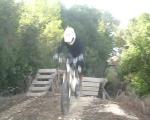
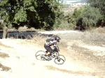
A short singletrack off the Horseshoe singletrack (aka Ayalon). Not very steep ,but 4-5 jumps over ancient agricultural terraces. ~1 m high each. Chicken lines available. Can be overgrown with vegetation, depending on the season.

Recent Activity on Trail

Past Week
  • 0 rides
  •  
6 Months
  • 0 rides
  •  
All
  • 0 rides
  • Last: Mar 7, 2020
update trails status or condition

Endless Trail Reports

no reports have been added for Endless yet, add a trail report.
Trail reports are used to indicate a trails current condition and inform builders and other riders about any issues on a trail.
Status:
no votes yet
Your vote: 0

view (9)
close
3D
Trail Conditions
  • Unknown
  • Snow Groomed
  • Snow Packed
  • Snow Covered
  • Snow Cover Partial
  • Freeze/thaw Cycle
  • Icy
  • Prevalent Mud
  • Wet
  • Variable
  • Ideal
  • Dry
  • Very Dry
Trail Flow (Ridden Direction)
Trailforks scans users ridelogs to determine the most popular direction each trail is ridden. A good flowing trail network will have most trails flowing in a single direction according to their intension.
The colour categories are based on what percentage of riders are riding a trail in its intended direction.
  • > 96%
  • > 90%
  • > 80%
  • > 70%
  • > 50%
  • < 50%
  • bi-directional trail
  • no data
Trail Last Ridden
Trailforks scans ridelogs to determine the last time a trail was ridden.
  • < 2 days
  • < 1 week
  • < 2 weeks
  • < 1 month
  • < 6 months
  • > 6 months
Trail Ridden Direction
The intended direction a trail should be ridden.
  • Downhill Only
  • Downhill Primary
  • Both Directions
  • Uphill Primary
  • Uphill Only
  • One Direction
Contribute Details
Colors indicate trail is missing specified detail.
  • Description
  • Photos
  • Description & Photos
  • Videos
Trail Popularity ?
Trailforks scans ridelogs to determine which trails are ridden the most in the last 9 months. Trails are compared with nearby trails in the same city region with a possible 25 colour shades. Think of this as a heatmap, more rides = more kinetic energy = warmer colors.
  • most popular
  • popular
  • less popular
  • not popular
ATV/ORV/OHV Filter
Max Vehicle Width
inches
US Cell Coverage
Legend
cell carrier legend

Radar Time
Activity Recordings
Trailforks uses anonymized public activity data. ?
Activity Recordings
Trailforks uses anonymized public activity data. ?
Personal Heatmap
Activity Types
all / none
Options
2
Date range month
Winter Trails
Warning A routing network for winter maps does not exist. Selecting trails using the winter trails layer has been disabled.
Missing Trails
Most Popular
Least Popular
Trails are colored based on popularity. The more popular a trail is, the more red. Less popular trails trend towards green.
Jump Magnitude Heatmap
Heatmap of where riders jump on trails. Zoom in to see individual jumps, click circles to view jump details.
BC Backroad Status

Service Road Atlas is a free to use, community-driven service for viewing and creating reports on the numerous back-country service roads around B.C. and Alberta.

map legend
Slope Aspect
Direction the slope faces
Flat N NE E SE S SW W NW
Trails Deemphasized
Trails are shown in grey.
disable
Only show trails with no bike usage.
Enable
Suggested Layers
Based on selected activity type

    Save the current map location and zoom level as your default home location whenever this page is loaded.

    Save
        Directions to endless trailhead (31.839220, 35.029820)

        Photos

        1 more »
        310 |
        Oct 26, 2012 @ 12:45pm
        Oct 26, 2012

        Videos

        4 more »
        The Return Of The Endless Riders
        53:57 | 185 | Jun 17, 2009 , My City
        Endless Riders 2007
        29:25 | 870 | Mar 30, 2008 , My City
        Endless Riders in Tsubike again
        4:44 | 575 | Oct 20, 2008 , My City
        Endless Riders do Tzubike
        3:33 | 215 | Oct 18, 2008 , My City

        3 Reviews & Comments


        We hope you've been enjoying Trailforks!

        Create a FREE account to view trail comments and much more.

        • By ziv2102TF Pro TRAILFORKS & contributors
        • #23081 - 1,181 views

        Frequently Asked Questions About Endless

        Where is Endless located?
        Endless is located in Canada Park, Israel. It is part of the Canada Park trail network. The trailhead is located at coordinates 31.83922, 35.02982.
        How hard is Endless?
        Endless is rated as Red difficulty.
        What is the elevation gain for Endless?
        The trail has 220 ft of elevation descent. The elevation ranges from 788 ft to 1,008 ft.
        Is Endless a point to point trail?
        Endless is not a point to point trail. The direction is Downhill Primary. The trail type is singletrack.

        Hit the Trail

        Open in App

        Get this trail on your phone instantly.
        open trail in app

        Download Trail

        Save to wishlist, Garmin & download.
        save the trail

        Find Related Routes

        Find routes and users activities that include this trail.
        find routes for this trail

        You must enter a description before submitting.