4,009 ft
Distance
227 ft
Climb
-12 ft
Descent
00:08:12
Avg time

Escalade Details

  • Activities
    • Mountain Bike
    • E-Bike
    • Hike
    • Trail Running
  • Riding Area
  • Difficulty Rating
  • Hiking SAC Scale
    T2 Mountain Hiking
  • Trail Type
    Singletrack
  • Bike Type
    XC
  • Direction
    Both Directions
    Popular direction shown
  • Climb Difficulty
    Green
  • Physical Rating
    Moderate
  • Trail Visibility
    Always easy to follow
  • Season
    Can ride all year round
  • Dogs Allowed
    Yes
  • eBike Allowed
    Yes up to Class 1
  • TTFs on Trail
    Jump
  • Global Ranking
    #2039 in Mountain Biking [+]
    • #139 in E-Biking
    • #46318 in Hiking
  • Local Popularity
    100 in Mountain Biking [+]
    • 100 in E-Biking
    • 80 in Trail Running
    • 100 in Hiking
  • Land Owner
    Redland City Council

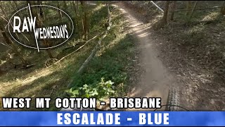
Escalade provides an enjoyable climb to the downhill hub at the top of Westy's. For the trip down, there are small jump features, doubles and big berms to enjoy.

Access Info

Access via Summit Track opposite Leo Lands

More Stats for Escalade mountain bike trail trail
  • Altitude change
    215 ft
  • Altitude min
    410 ft
  • Altitude max
    625 ft
  • Altitude start
    410 ft
  • Altitude end
    627 ft
  • Grade
    5.4%
  • Grade max
    -11.5%
  • Grade min
    25.4%
  • Distance climb
    3,061 ft
  • Distance down
    515 ft
  • Distance flat
    433 ft
  • Avg time
    00:08:12
  • Avg reverse time
    00:04:40
  • view trail stats
Status:
on Feb 28, 2025
Ideal
Avg: 4.21 (3 votes)
Your vote: 0

view (25,740)
close
3D
Trail Conditions
  • Unknown
  • Snow Groomed
  • Snow Packed
  • Snow Covered
  • Snow Cover Partial
  • Freeze/thaw Cycle
  • Icy
  • Prevalent Mud
  • Wet
  • Variable
  • Ideal
  • Dry
  • Very Dry
Trail Flow (Ridden Direction)
Trailforks scans users ridelogs to determine the most popular direction each trail is ridden. A good flowing trail network will have most trails flowing in a single direction according to their intension.
The colour categories are based on what percentage of riders are riding a trail in its intended direction.
  • > 96%
  • > 90%
  • > 80%
  • > 70%
  • > 50%
  • < 50%
  • bi-directional trail
  • no data
Trail Last Ridden
Trailforks scans ridelogs to determine the last time a trail was ridden.
  • < 2 days
  • < 1 week
  • < 2 weeks
  • < 1 month
  • < 6 months
  • > 6 months
Trail Ridden Direction
The intended direction a trail should be ridden.
  • Downhill Only
  • Downhill Primary
  • Both Directions
  • Uphill Primary
  • Uphill Only
  • One Direction
Contribute Details
Colors indicate trail is missing specified detail.
  • Description
  • Photos
  • Description & Photos
  • Videos
Trail Popularity ?
Trailforks scans ridelogs to determine which trails are ridden the most in the last 9 months. Trails are compared with nearby trails in the same city region with a possible 25 colour shades. Think of this as a heatmap, more rides = more kinetic energy = warmer colors.
  • most popular
  • popular
  • less popular
  • not popular
ATV/ORV/OHV Filter
Max Vehicle Width
inches
US Cell Coverage
Legend
cell carrier legend

Radar Time
x Activity Recordings
Trailforks users anonymized public ridelogs from the past 6 months.
  • mountain biking recent
  • mountain biking (>6 month)
  • hiking (1 year)
  • moto (1 year)
Activity Recordings
Trailforks users anonymized public skilogs from the past 12 months.
  • Downhill Ski
  • Backcountry Ski
  • Nordic Ski
  • Snowmobile
Winter Trails
Warning A routing network for winter maps does not exist. Selecting trails using the winter trails layer has been disabled.
x Missing Trails
Most Popular
Least Popular
Trails are colored based on popularity. The more popular a trail is, the more red. Less popular trails trend towards green.
Jump Magnitude Heatmap
Heatmap of where riders jump on trails. Zoom in to see individual jumps, click circles to view jump details.
Trails Deemphasized
Trails are shown in grey.
disable
Only show trails with NO bikes.
enable

Save the current map location and zoom level as your default home location whenever this page is loaded.

Save
      Directions to escalade trailhead (-27.609460, 153.206630)

      Recent Ridelog Activity on Trail

      Past Week
      • 6 rides
      • 26.5 km avg distance
      6 Months
      • 118 rides
      • 15.7 km avg distance
      All
      • 1,396 rides
      • Last: Apr 23, 2025

      Photos

      more »
      126 |
      May 18, 2021 @ 11:40pm
      May 18, 2021
      208 |
      Feb 28, 2021 @ 9:07pm
      Feb 28, 2021

      3 Reviews & Comments


      We hope you've been enjoying Trailforks!

      Create a FREE account to view trail comments and much more.

      Videos

      more »
      youtuber These NEW Trails are Amazing! - Eastern...
      12:29 | 532 | Mar 20, 2021 , Redland City
      youtuber Am I Fast Enough to Claim the #1 Spot?
      7:54 | 398 | Apr 3, 2021 , Redland City
      youtuber ESCALADE DOWN | West Mt Cotton | RAW WEDNESDAYS
      3:11 | 189 | Sep 30, 2022 , Redland City
      • By TrailsplannerTF Pro & contributors
      • #403204 - 1,729 views

      You must enter a description before submitting.