more stats
2,582 ft
Distance
-348 ft
Descent
00:03:43
Avg time
-348 ft
Altitude change
318 ft
Altitude min
666 ft
Altitude max
666 ft
Altitude start
318 ft
Altitude end
-13.5%
Grade
-43.8%
Grade max
-1.8%
Grade min
39 ft
Distance climb
2,451 ft
Distance down
66 ft
Distance flat
00:03:43
Avg time

Fall Line Details

  • Activities
    • Mountain Bike
    • E-Bike
  • Riding Area
  • Ref Number
    #9
  • AKA
    Track 8
  • Difficulty Rating
  • Voted Difficulty
    Black Diamond (4 votes)
  • Local Popularity
    90 in Mountain Biking [+]
    • 100 in E-Biking
  • Global Ranking
    #1042 in Mountain Biking [+]
    • #1710 in E-Biking
  • Trail Type
    Singletrack
  • Bike Type
    AM
  • Direction
    Downhill Only
    Popular Direction Shown
  • Physical Rating
    Moderate
  • eBike Allowed
    Yes up to Class 1
  • TTFs on Trail
    Berm, Drop, Jump, Rock Garden
  • Ride in Rain
    Yes
  • Year Opened
    2013

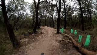
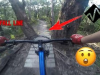
This is one of the many trails in the OT dam AKA (the park). Fall Line is a great track with heaps of flowing berms that you can rail. There are also lots of fast strait sections that you can pedal to gain speed to hit the jumps.

Trail Supporters
Local Trail Association
Traditionally Indigenous Territory

Recent Activity on Trail

Past Week
  • 3 rides
  • 13 miles average
6 Months
  • 139 rides
  • 12 miles avg distance
All
  • 1,084 rides
  • Last: Jul 3, 2026
c1c2c3c4
January
February
March
April
May
June
July
August
September
October
November
December
update trails status or condition

Fall Line Trail Reports

Status:
on Jun 14, 2026
Wet
Avg: 4.31 (25 votes)
Your vote: 0

view (12,566)
close
3D
Trail Conditions
  • Unknown
  • Snow Groomed
  • Snow Packed
  • Snow Covered
  • Snow Cover Partial
  • Freeze/thaw Cycle
  • Icy
  • Prevalent Mud
  • Wet
  • Variable
  • Ideal
  • Dry
  • Very Dry
Trail Flow (Ridden Direction)
Trailforks scans users ridelogs to determine the most popular direction each trail is ridden. A good flowing trail network will have most trails flowing in a single direction according to their intension.
The colour categories are based on what percentage of riders are riding a trail in its intended direction.
  • > 96%
  • > 90%
  • > 80%
  • > 70%
  • > 50%
  • < 50%
  • bi-directional trail
  • no data
Trail Last Ridden
Trailforks scans ridelogs to determine the last time a trail was ridden.
  • < 2 days
  • < 1 week
  • < 2 weeks
  • < 1 month
  • < 6 months
  • > 6 months
Trail Ridden Direction
The intended direction a trail should be ridden.
  • Downhill Only
  • Downhill Primary
  • Both Directions
  • Uphill Primary
  • Uphill Only
  • One Direction
Contribute Details
Colors indicate trail is missing specified detail.
  • Description
  • Photos
  • Description & Photos
  • Videos
Trail Popularity ?
Trailforks scans ridelogs to determine which trails are ridden the most in the last 9 months. Trails are compared with nearby trails in the same city region with a possible 25 colour shades. Think of this as a heatmap, more rides = more kinetic energy = warmer colors.
  • most popular
  • popular
  • less popular
  • not popular
ATV/ORV/OHV Filter
Max Vehicle Width
inches
US Cell Coverage
Legend
cell carrier legend

Radar Time
Activity Recordings
Trailforks uses anonymized public activity data. ?
Activity Recordings
Trailforks uses anonymized public activity data. ?
Personal Heatmap
Activity Types
all / none
Options
2
Date range month
Winter Trails
Warning A routing network for winter maps does not exist. Selecting trails using the winter trails layer has been disabled.
Missing Trails
Most Popular
Least Popular
Trails are colored based on popularity. The more popular a trail is, the more red. Less popular trails trend towards green.
Jump Magnitude Heatmap
Heatmap of where riders jump on trails. Zoom in to see individual jumps, click circles to view jump details.
BC Backroad Status

Service Road Atlas is a free to use, community-driven service for viewing and creating reports on the numerous back-country service roads around B.C. and Alberta.

map legend
Slope Aspect
Direction the slope faces
Flat N NE E SE S SW W NW
Trails Deemphasized
Trails are shown in grey.
disable
Only show trails with no bike usage.
Enable
Suggested Layers
Based on selected activity type

    Save the current map location and zoom level as your default home location whenever this page is loaded.

    Save
        Directions to fall-line trailhead (-38.353750, 144.984430)

        Photos

        18 more »
        207 |
        Nov 23, 2020 @ 12:25am
        Nov 23, 2020
        247 |
        Nov 22, 2020 @ 12:09am
        Nov 22, 2020
        174 |
        Nov 22, 2020 @ 12:09am
        Nov 22, 2020
        167 |
        Nov 22, 2020 @ 12:09am
        Nov 22, 2020

        Videos

        7 more »
        youtuber Red Hill Fall Line Updated August 2024
        2:09 | 76 | Aug 31, 2024 , Dromana
        youtuber Rock Salt into Fall Line  \\  Red Hill
        3:42 | 545 | Jul 24, 2023 , Dromana
        youtuber Fall Line – Red Hill MTB
        2:14 | 914 | Jul 14, 2022 , Dromana
        Red Hill-Fall line
        658 | Oct 8, 2021 , Dromana

        Routes with this trail

        5 miles 1,106 ft 4
        The Mini Enduro course map
        12 miles 2,290 ft 8
        Full stage map course Search of Stoke
        3 miles 727 ft 5 Race
        "A mountain bike event designed to be inclusive to all riders identifying as female, working to support...

        15 Reviews & Comments


        We hope you've been enjoying Trailforks!

        Create a FREE account to view trail comments and much more.

        • By Decomeko & contributors
        • #28395 - 5,651 views

        Frequently Asked Questions About Fall Line

        Where is Fall Line located?
        Fall Line is located in Red Hill Mountain Bike Park, Dromana, Australia. It is part of the Red Hill Mountain Bike Park trail network. The trailhead is located at coordinates -38.35375, 144.98443.
        How hard is Fall Line?
        Fall Line is rated as Black Diamond difficulty. The physical rating is Moderate. The average grade is 13.5%.
        What is the elevation gain for Fall Line?
        The trail has 348 ft of elevation descent. The elevation ranges from 318 ft to 666 ft.
        Is Fall Line a point to point trail?
        Yes, Fall Line is a point to point trail. The direction is Downhill Only. The trail type is singletrack.

        Hit the Trail

        Open in App

        Get this trail on your phone instantly.
        open trail in app

        Download Trail

        Save to wishlist, Garmin & download.
        save the trail

        Find Related Routes

        Find routes and users activities that include this trail.
        find routes for this trail

        You must enter a description before submitting.