more stats
1.4 miles
Distance
115 ft
Climb
-1,549 ft
Descent
00:21:15
Avg time
-1,434 ft
Altitude change
2,413 ft
Altitude min
3,847 ft
Altitude max
3,847 ft
Altitude start
2,413 ft
Altitude end
-19.373%
Grade
-63.774%
Grade max
38.821%
Grade min
947 ft
Distance climb
1 mile
Distance down
80 ft
Distance flat
00:21:15
Avg time

Fiammineda Details

  • Activities
    • Mountain Bike
    • Hike
    • Trail Running
  • Riding Area
    Corno alle Scale
    Lizzano in Belvedere
  • Difficulty Rating
  • Voted Difficulty
    Double Black Diamond (1 vote)
  • Local Popularity
    70 in Mountain Biking [+]
    • 5 in Trail Running
    • 90 in Hiking
  • Global Ranking
    #82002 in Mountain Biking [+]
    • #141298 in Trail Running
    • #38384 in Hiking
  • Trail Type
    Singletrack
  • Bike Type
    DH, AM
  • Direction
    Downhill Only
    Popular Direction Shown
  • Physical Rating
    Hard
  • Trail Visibility
    Sometimes hard to follow
  • Dogs Allowed
    Yes
  • TTFs on Trail
    Rock Face, Rock Garden

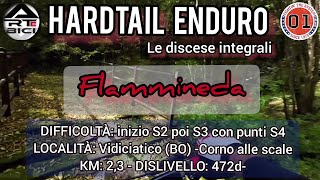
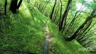
Primo tratto piuttosto semplice (quando l'erba è sotto controllo), poi subito diventa molto ripido con passaggi di rock garden davvero molto impegnativi, alcuni tornanti molto stretti, di cui un paio direi quasi impossibili senza nose press. Tratti anche su terra molto ripida con radici e contropendenze. Insomma un bel test per mettere alla prova la vostra abilità di guida. Sconsigliabile ha chi non ha già dimestichezza con questo tipo di discese essendo anche piuttosto lunga.

Recent Activity on Trail

Past Week
  • 0 rides
  •  
6 Months
  • 3 rides
  • 25 miles avg distance
All
  • 13 rides
  • Last: Jun 28, 2026
c1c2c3c4
January
February
March
April
May
June
July
August
September
October
November
December
update trails status or condition

Fiammineda Trail Reports

statusdatedescription
Jun 14, 2026 @ 9:39am (Europe/San_Marino)
Jun 14, 2026
Perfetta, segnalo ancora la presenza degli alberi a fine sentiero facilmente scavalcabili scendendo dalla bici..
Apr 12, 2026 @ 7:16pm (Europe/Rome)
Apr 12, 2026
super sentiero per chi ama il tecnico...a fine sentiero verso la fontana ci sono tra alberi caduti
Oct 18, 2025 @ 9:52am (Europe/San_Marino)
Oct 18, 2025
Aug 3, 2025 @ 11:46pm
Aug 3, 2025
Jun 27, 2025 @ 9:44am
Jun 27, 2025
more »
Status:
on Jun 14, 2026
Ideal
Avg: 4.24 (2 votes)
Your vote: 0

view (101)
close
3D
Trail Conditions
  • Unknown
  • Snow Groomed
  • Snow Packed
  • Snow Covered
  • Snow Cover Partial
  • Freeze/thaw Cycle
  • Icy
  • Prevalent Mud
  • Wet
  • Variable
  • Ideal
  • Dry
  • Very Dry
Trail Flow (Ridden Direction)
Trailforks scans users ridelogs to determine the most popular direction each trail is ridden. A good flowing trail network will have most trails flowing in a single direction according to their intension.
The colour categories are based on what percentage of riders are riding a trail in its intended direction.
  • > 96%
  • > 90%
  • > 80%
  • > 70%
  • > 50%
  • < 50%
  • bi-directional trail
  • no data
Trail Last Ridden
Trailforks scans ridelogs to determine the last time a trail was ridden.
  • < 2 days
  • < 1 week
  • < 2 weeks
  • < 1 month
  • < 6 months
  • > 6 months
Trail Ridden Direction
The intended direction a trail should be ridden.
  • Downhill Only
  • Downhill Primary
  • Both Directions
  • Uphill Primary
  • Uphill Only
  • One Direction
Contribute Details
Colors indicate trail is missing specified detail.
  • Description
  • Photos
  • Description & Photos
  • Videos
Trail Popularity ?
Trailforks scans ridelogs to determine which trails are ridden the most in the last 9 months. Trails are compared with nearby trails in the same city region with a possible 25 colour shades. Think of this as a heatmap, more rides = more kinetic energy = warmer colors.
  • most popular
  • popular
  • less popular
  • not popular
ATV/ORV/OHV Filter
Max Vehicle Width
inches
US Cell Coverage
Legend
cell carrier legend

Radar Time
Activity Recordings
Trailforks uses anonymized public activity data. ?
Activity Recordings
Trailforks uses anonymized public activity data. ?
Personal Heatmap
Activity Types
all / none
Options
2
Date range month
Winter Trails
Warning A routing network for winter maps does not exist. Selecting trails using the winter trails layer has been disabled.
Missing Trails
Most Popular
Least Popular
Trails are colored based on popularity. The more popular a trail is, the more red. Less popular trails trend towards green.
Jump Magnitude Heatmap
Heatmap of where riders jump on trails. Zoom in to see individual jumps, click circles to view jump details.
BC Backroad Status

Service Road Atlas is a free to use, community-driven service for viewing and creating reports on the numerous back-country service roads around B.C. and Alberta.

map legend
Slope Aspect
Direction the slope faces
Flat N NE E SE S SW W NW
Trails Deemphasized
Trails are shown in grey.
disable
Only show trails with no bike usage.
Enable
Suggested Layers
Based on selected activity type

    Save the current map location and zoom level as your default home location whenever this page is loaded.

    Save
        Directions to fiammineda trailhead (44.152313, 10.878718)

        Photos

        0 more »
        25 |
        Aug 3, 2025 @ 11:46pm
        Aug 3, 2025

        Videos

        3 more »
        Discesa Fiammineda Corno alle Scale (BO) video...
        15:26 | 41 | Nov 1, 2025 , Lizzano in Belvedere
        Poker di discese nel parco Corno alle Scale...
        16:05 | 19 | Oct 20, 2025 , Lizzano in Belvedere
        Trail Fiammineda, Monte Pizzo, Appennino Bolognese
        8:16 | 32 | Jul 25, 2025 , Lizzano in Belvedere

        1 Review & Comments


        We hope you've been enjoying Trailforks!

        Create a FREE account to view trail comments and much more.

        Nearby Trails

        • By Gullo & contributors
        • #84618 - 1,376 views

        Frequently Asked Questions About Fiammineda

        Where is Fiammineda located?
        Fiammineda is located in Corno alle Scale, Lizzano in Belvedere, Italy. It is part of the Corno alle Scale trail network. The trailhead is located at coordinates 44.15231, 10.87872.
        How hard is Fiammineda?
        Fiammineda is rated as Black difficulty. The physical rating is Hard. The average grade is 19.373%.
        What is the elevation gain for Fiammineda?
        Fiammineda has 35 m of elevation gain. The trail has 472 m of elevation descent. The elevation ranges from 736 m to 1,173 m.
        Is Fiammineda a point to point trail?
        Yes, Fiammineda is a point to point trail. The direction is Downhill Only. The trail type is singletrack.

        Hit the Trail

        Open in App

        Get this trail on your phone instantly.
        open trail in app

        Download Trail

        Save to wishlist, Garmin & download.
        save the trail

        Find Related Routes

        Find routes and users activities that include this trail.
        find routes for this trail

        You must enter a description before submitting.