Filo de la Risa Details
-
Activities
- Mountain Bike
- E-Bike
- Hike
- Trail Running
-
Riding Area
-
Difficulty Rating
-
Trail TypeSingletrack
-
Bike TypeAM, XC
-
DirectionDownhill PrimaryPopular direction shown
-
Climb DifficultyBlack Diamond
-
Physical RatingHard
-
Dogs AllowedYes
-
eBike AllowedYes up to Class 1
-
Global Ranking
-
Local Popularity75 in Mountain Biking [+]
- 5 in E-Biking
- 5 in Trail Running
- 5 in Hiking
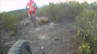
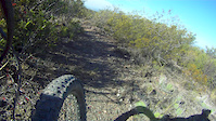
El Filo de la Risa, es uno de los mejores senderos para hacer enduro de mendoza, Tiene una pendiente bastante constante pero con unos sectores mas rápidos cada tanto, Mucha curva y contra curva siguiendo un filo que por partes se pone mas ancho y en otros sectores se pone bastante estrecho con unos bordes bastante altos. Este sendero es un ejemplo de como se logra hacer fluido un sendero salvaje con algo de trabajo.
Local Trail Association
-

-
Please consider joining or donating to the local trail association to supportdonate to earn trail karma!
trail development & maintenance.
More Stats for Filo de la Risa mountain bike trail trail
-
Altitude change-653 ft
-
Altitude min4,059 ft
-
Altitude max4,712 ft
-
Altitude start4,712 ft
-
Altitude end4,059 ft
-
Grade-6.734%
-
Grade max-32.682%
-
Grade min13.879%
-
Distance climb550 ft
-
Distance down2 miles
-
Distance flat724 ft
-
Avg time00:15:27
-
Avg reverse time00:07:05
- view trail stats
-
Layers w
- Map Content
- More Layers
- Pro
- Pro
- Pro
- Pro
- Pro
- Pro
- Pro
- Pro
-
Upgrade to

- Unknown
- Snow Groomed
- Snow Packed
- Snow Covered
- Snow Cover Partial
- Freeze/thaw Cycle
- Icy
- Prevalent Mud
- Wet
- Variable
- Ideal
- Dry
- Very Dry
The colour categories are based on what percentage of riders are riding a trail in its intended direction.
- > 96%
- > 90%
- > 80%
- > 70%
- > 50%
- < 50%
- bi-directional trail
- no data
- < 2 days
- < 1 week
- < 2 weeks
- < 1 month
- < 6 months
- > 6 months
- Downhill Only
- Downhill Primary
- Both Directions
- Uphill Primary
- Uphill Only
- One Direction
- Description
- Photos
- Description & Photos
- Videos
- most popular
- popular
- less popular
- not popular

- mountain biking recent
- mountain biking (>6 month)
- hiking (1 year)
- moto (1 year)
- Downhill Ski
- Backcountry Ski
- Nordic Ski
- Snowmobile
Save the current map location and zoom level as your default home location whenever this page is loaded.
SaveFilo de la Risa Trail Reports
Trail reports are used to indicate a trails current condition and inform builders and other riders about any issues on a trail.
Recent Ridelog Activity on Trail
- 0 rides
- 12 rides
- 19 miles avg distance
- 202 rides
- Last: May 4, 2024
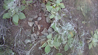
Photos
Reviews / Comments
No reviews yet, be the first to write a review or ask a question.
Use trail reports to comment on trail conditions.
We hope you've been enjoying Trailforks!
Create a FREE account to view trail comments and much more.
Videos
Nearby Trails
- Variante Bajada Del Eco 2,178 ft
- La Sonrisa 2,343 ft
- La Picada De La Piedra Pelada 2,346 ft
- Infiernillo Ii 3,655 ft
- La Pampa Del Flaco 3,675 ft
Tranquera, Barcito, Colonia, Papagallos
- By MTBar
 & contributors
 - #135287 - 1,920 views
- follow/subscribe
- login to download gpx or kml files.
You must enter a description before submitting.