3,937 ft
Distance
69 ft
Climb
-230 ft
Descent
00:10:37
Avg time

Fire Tower Details

  • Activities
    • Mountain Bike
    • E-Bike
    • Hike
    • Trail Running
  • Riding Area
    Achnabreac
    lochgilphead
  • Difficulty Rating
  • Trail Type
    Singletrack
  • Bike Type
    XC
  • Direction
    Downhill Primary
    Popular direction shown
  • Climb Difficulty
    Green
  • Physical Rating
    Easy
  • Season
    All year but rocks slidey in wet
  • Dogs Allowed
    Yes
  • eBike Allowed
  • Ride in Rain
    Yes
  • Global Ranking
    #79487 in Mountain Biking [+]
    • #25102 in E-Biking
  • Local Popularity
    95 in Mountain Biking [+]
    • 75 in E-Biking
    • 5 in Trail Running
    • 5 in Hiking
  • Land Owner
    Forestry commission

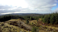
Easy red trail descent with forest road climb and amazing panorama views from top. Tiny black trail at top but barely any speed needed for it. Badly signposted with the best trails at the top and the worst at the bottom. Takes ages to get to the top though.

source: ...
Access Info

If coming from Lochgilphead direction turn right after Cairnbaan and go along the track to the car park. There is a map here and also some walking trails and a tiny pump/jump track. Come out of the car park and turn right and continue up the forest track. You will reach another small parking space. This is where the lowest down the hill trail starts. The forest road will go downhill for a bit and you should turn left onto a small fun track which basically just cuts the corner. You will go uphill and then over a bridge which you turn right to do the water splash trail or left for the good stuff at the top. Assuming you want to go to the top you keep turning right at the forks and you will reach the top of the trail. It's a long climb but remember for every uphill there is a downhill.

More Stats for Fire Tower mountain bike trail trail
  • Altitude change
    -160 ft
  • Altitude min
    505 ft
  • Altitude max
    737 ft
  • Altitude start
    665 ft
  • Altitude end
    505 ft
  • Grade
    -4.1%
  • Grade max
    -27.9%
  • Grade min
    12%
  • Distance climb
    1,572 ft
  • Distance down
    2,365 ft
  • Avg time
    00:10:37
  • view trail stats
Status:
on Oct 31, 2024
Prevalent Mud
Avg: 3.76 (3 votes)
Your vote: 0

view (148)
close
3D
Trail Conditions
  • Unknown
  • Snow Groomed
  • Snow Packed
  • Snow Covered
  • Snow Cover Partial
  • Freeze/thaw Cycle
  • Icy
  • Prevalent Mud
  • Wet
  • Variable
  • Ideal
  • Dry
  • Very Dry
Trail Flow (Ridden Direction)
Trailforks scans users ridelogs to determine the most popular direction each trail is ridden. A good flowing trail network will have most trails flowing in a single direction according to their intension.
The colour categories are based on what percentage of riders are riding a trail in its intended direction.
  • > 96%
  • > 90%
  • > 80%
  • > 70%
  • > 50%
  • < 50%
  • bi-directional trail
  • no data
Trail Last Ridden
Trailforks scans ridelogs to determine the last time a trail was ridden.
  • < 2 days
  • < 1 week
  • < 2 weeks
  • < 1 month
  • < 6 months
  • > 6 months
Trail Ridden Direction
The intended direction a trail should be ridden.
  • Downhill Only
  • Downhill Primary
  • Both Directions
  • Uphill Primary
  • Uphill Only
  • One Direction
Contribute Details
Colors indicate trail is missing specified detail.
  • Description
  • Photos
  • Description & Photos
  • Videos
Trail Popularity ?
Trailforks scans ridelogs to determine which trails are ridden the most in the last 9 months. Trails are compared with nearby trails in the same city region with a possible 25 colour shades. Think of this as a heatmap, more rides = more kinetic energy = warmer colors.
  • most popular
  • popular
  • less popular
  • not popular
ATV/ORV/OHV Filter
Max Vehicle Width
inches
US Cell Coverage
Legend
cell carrier legend

Radar Time
x Activity Recordings
Trailforks users anonymized public ridelogs from the past 6 months.
  • mountain biking recent
  • mountain biking (>6 month)
  • hiking (1 year)
  • moto (1 year)
Activity Recordings
Trailforks users anonymized public skilogs from the past 12 months.
  • Downhill Ski
  • Backcountry Ski
  • Nordic Ski
  • Snowmobile
Winter Trails
Warning A routing network for winter maps does not exist. Selecting trails using the winter trails layer has been disabled.
x Missing Trails
Most Popular
Least Popular
Trails are colored based on popularity. The more popular a trail is, the more red. Less popular trails trend towards green.
Jump Magnitude Heatmap
Heatmap of where riders jump on trails. Zoom in to see individual jumps, click circles to view jump details.
Trails Deemphasized
Trails are shown in grey.
disable
Only show trails with NO bikes.
enable

Save the current map location and zoom level as your default home location whenever this page is loaded.

Save
      Directions to fire-tower trailhead (56.076455, -5.406604)
      update trails status or condition

      Fire Tower Trail Reports

      statusdatedescription
      Oct 31, 2024 @ 8:24am
      Oct 31, 2024
      Patches of mud in lots of places, so can be a bit sketchy
      Aug 9, 2019 @ 2:18am
      Aug 9, 2019
      Downhill section will be sketchy reduce speed
      Jul 31, 2018 @ 1:17am
      Jul 31, 2018
      Apr 15, 2018 @ 5:21am
      Apr 15, 2018
      Bottom section closed due to car park work until May.
      Jun 11, 2017 @ 5:38pm
      Jun 11, 2017
      view all reports »

      Recent Ridelog Activity on Trail

      Past Week
      • 0 rides
      •  
      6 Months
      • 1 rides
      • 10 miles avg distance
      All
      • 11 rides
      • Last: May 27, 2025

      Photos

      more »
      140 |
      Apr 3, 2017 @ 10:05am
      Apr 3, 2017
      123 |
      Apr 3, 2017 @ 10:05am
      Apr 3, 2017
      414 |
      Apr 22, 2015 @ 12:50pm
      Apr 22, 2015
      557 |
      Apr 12, 2015 @ 9:40am
      Apr 12, 2015

      1 Review & Comments


      We hope you've been enjoying Trailforks!

      Create a FREE account to view trail comments and much more.

      Videos

      more »
      Fire Tower
      2:19 | 451 | Mar 15, 2015 , lochgilphead
      • By I4MSTEVE & contributors
      • #26561 - 4,737 views

      You must enter a description before submitting.