1.1 miles
Distance
191 ft
Climb
-247 ft
Descent
00:16:38
Avg time

Flat Rock Details

  • Activities
    • Mountain Bike
    • Hike
    • Trail Running
  • Riding Area
    Sawmill Hills
    Northampton, Massachusetts
  • Difficulty Rating
  • Voted Difficulty
    Black Diamond (1 vote)
  • Hiking SAC Scale
    T1 Hiking
  • Trail Type
    Singletrack
  • Bike Type
    AM, Fat
  • Direction
    Both Directions
    Popular direction shown
  • eBike Allowed
  • TTFs on Trail
    Rock Face, Rock Garden
  • Global Ranking
    #49841 in Mountain Biking [+]
    • #31764 in Hiking
  • Local Popularity
    95 in Mountain Biking [+]
    • 85 in Trail Running
    • 75 in Hiking

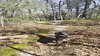
Flat Rock is a difficult trail with some big exposed rock slabs at the start from Old Carriage Trail . The long smooth rocks provide a bit of relief from the jumble of roots and rocks that are the rest of Sawmill. The is a significant rock garden gully near the end where it joins White Trail. The area in between has a nice mix of flow and achievable technical features.

Local Trail Association
Traditionally Indigenous Territory
More Stats for Flat Rock mountain bike trail trail
  • Altitude change
    -55 ft
  • Altitude min
    380 ft
  • Altitude max
    546 ft
  • Altitude start
    499 ft
  • Altitude end
    443 ft
  • Grade
    -0.9%
  • Grade max
    -17.4%
  • Grade min
    22.9%
  • Distance climb
    1,913 ft
  • Distance down
    2,464 ft
  • Distance flat
    1,516 ft
  • Avg time
    00:16:38
  • Avg reverse time
    00:21:27
  • view trail stats
Status:
on Apr 21, 2025
Variable
Avg: 3.99 (4 votes)
Your vote: 0

view (1,493)
close
3D
Trail Conditions
  • Unknown
  • Snow Groomed
  • Snow Packed
  • Snow Covered
  • Snow Cover Partial
  • Freeze/thaw Cycle
  • Icy
  • Prevalent Mud
  • Wet
  • Variable
  • Ideal
  • Dry
  • Very Dry
Trail Flow (Ridden Direction)
Trailforks scans users ridelogs to determine the most popular direction each trail is ridden. A good flowing trail network will have most trails flowing in a single direction according to their intension.
The colour categories are based on what percentage of riders are riding a trail in its intended direction.
  • > 96%
  • > 90%
  • > 80%
  • > 70%
  • > 50%
  • < 50%
  • bi-directional trail
  • no data
Trail Last Ridden
Trailforks scans ridelogs to determine the last time a trail was ridden.
  • < 2 days
  • < 1 week
  • < 2 weeks
  • < 1 month
  • < 6 months
  • > 6 months
Trail Ridden Direction
The intended direction a trail should be ridden.
  • Downhill Only
  • Downhill Primary
  • Both Directions
  • Uphill Primary
  • Uphill Only
  • One Direction
Contribute Details
Colors indicate trail is missing specified detail.
  • Description
  • Photos
  • Description & Photos
  • Videos
Trail Popularity ?
Trailforks scans ridelogs to determine which trails are ridden the most in the last 9 months. Trails are compared with nearby trails in the same city region with a possible 25 colour shades. Think of this as a heatmap, more rides = more kinetic energy = warmer colors.
  • most popular
  • popular
  • less popular
  • not popular
ATV/ORV/OHV Filter
Max Vehicle Width
inches
US Cell Coverage
Legend
cell carrier legend

Radar Time
x Activity Recordings
Trailforks users anonymized public ridelogs from the past 6 months.
  • mountain biking recent
  • mountain biking (>6 month)
  • hiking (1 year)
  • moto (1 year)
Activity Recordings
Trailforks users anonymized public skilogs from the past 12 months.
  • Downhill Ski
  • Backcountry Ski
  • Nordic Ski
  • Snowmobile
Winter Trails
Warning A routing network for winter maps does not exist. Selecting trails using the winter trails layer has been disabled.
x Missing Trails
Most Popular
Least Popular
Trails are colored based on popularity. The more popular a trail is, the more red. Less popular trails trend towards green.
Jump Magnitude Heatmap
Heatmap of where riders jump on trails. Zoom in to see individual jumps, click circles to view jump details.
Trails Deemphasized
Trails are shown in grey.
disable
Only show trails with NO bikes.
enable

Save the current map location and zoom level as your default home location whenever this page is loaded.

Save
      Directions to flat-rock trailhead (42.320560, -72.708480)
      update trails status or condition

      Flat Rock Trail Reports

      statusdatedescription
      Apr 21, 2025 @ 10:55am
      Apr 21, 2025
      Very technical chunky rocks
      Sep 23, 2024 @ 2:44pm
      Sep 23, 2024
      reporter second tree down
      Sep 23, 2024 @ 2:39pm
      Sep 23, 2024
      reporter
      Aug 3, 2023 @ 2:40am
      Aug 3, 2023
      Mar 31, 2023 @ 12:22am
      Mar 31, 2023
      reporter
      view all reports »

      Recent Ridelog Activity on Trail

      Past Week
      • 3 rides
      • 8 miles avg distance
      6 Months
      • 32 rides
      • 8 miles avg distance
      All
      • 456 rides
      • Last: Apr 24, 2025

      Photos

      more »
      132 |
      Jul 9, 2019 @ 5:20pm
      Jul 9, 2019
      170 |
      Jul 9, 2019 @ 5:19pm
      Jul 9, 2019
      1 |
      Sep 23, 2024 @ 2:45pm
      Sep 23, 2024
      4 |
      Sep 23, 2024 @ 2:40pm
      Sep 23, 2024

      Routes with this trail

      more »
      titledistance
      New Fun Sawmill Loop6 miles
      ChartPak Single Track6 miles
      Chartpack white down 226 miles
      Group Loop6 miles

      Reviews / Comments

      No reviews yet, be the first to write a review or ask a question.
      Use trail reports to comment on trail conditions.


      We hope you've been enjoying Trailforks!

      Create a FREE account to view trail comments and much more.

      Videos

      more »
      Sawmills Mountain Biking, Northampton Ma
      28:22 | 377 | Jun 12, 2023 , Northampton
      Saw Mill Hills
      | Feb 19, 2024 , Northampton
      • By StephaneMarceauTF Pro TRAILFORKS & contributors
      • #104372 - 1,154 views

      You must enter a description before submitting.