5,167 ft
Distance
-482 ft
Descent
00:11:29
Avg time
Supporters, Builders, Maintainers & Land Managers of Flintstone Trail

  • Sponsor

Flintstone Details

  • Activities
    • Mountain Bike
  • Riding Area
    Mountain Ranch Bike Park
    Eagle Mountain, Utah
  • Difficulty Rating
  • Voted Difficulty
    Double Black Diamond (1 vote)
  • Trail Type
    Singletrack
  • Bike Type
    DH, AM, XC
  • Direction
    Downhill Only
    Popular direction shown
  • Physical Rating
    Moderate
  • Dogs Allowed
    Yes
  • TTFs on Trail
    A-Frame, Bridge, Drop, Jump, Gap Jump, Rock Face, Rock Garden, Roller Coaster, Skinny
  • Local Popularity
    90 in Mountain Biking

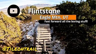
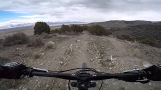
Fun DH trail with several features, rock drops, and gaps to jump. A few rocky drops may take you by surprise.

This trail is unsanctioned.

Disclaimer

Trail is strictly for mountain bike or hiking use. All others will be cited.

Traditionally Indigenous Territory
More Stats for Flintstone mountain bike trail trail
  • Altitude change
    -482 ft
  • Altitude min
    4,882 ft
  • Altitude max
    5,365 ft
  • Altitude start
    5,365 ft
  • Altitude end
    4,882 ft
  • Grade
    -9.3%
  • Grade max
    -26.6%
  • Grade min
    -0.5%
  • Distance down
    5,046 ft
  • Distance flat
    125 ft
  • Avg time
    00:11:29
  • Avg reverse time
    00:29:47
  • view trail stats
Status:
on Apr 11, 2025
Dry
Avg: 4.53 (31 votes)
Your vote: 0

view (1,937)
close
3D
Trail Conditions
  • Unknown
  • Snow Groomed
  • Snow Packed
  • Snow Covered
  • Snow Cover Partial
  • Freeze/thaw Cycle
  • Icy
  • Prevalent Mud
  • Wet
  • Variable
  • Ideal
  • Dry
  • Very Dry
Trail Flow (Ridden Direction)
Trailforks scans users ridelogs to determine the most popular direction each trail is ridden. A good flowing trail network will have most trails flowing in a single direction according to their intension.
The colour categories are based on what percentage of riders are riding a trail in its intended direction.
  • > 96%
  • > 90%
  • > 80%
  • > 70%
  • > 50%
  • < 50%
  • bi-directional trail
  • no data
Trail Last Ridden
Trailforks scans ridelogs to determine the last time a trail was ridden.
  • < 2 days
  • < 1 week
  • < 2 weeks
  • < 1 month
  • < 6 months
  • > 6 months
Trail Ridden Direction
The intended direction a trail should be ridden.
  • Downhill Only
  • Downhill Primary
  • Both Directions
  • Uphill Primary
  • Uphill Only
  • One Direction
Contribute Details
Colors indicate trail is missing specified detail.
  • Description
  • Photos
  • Description & Photos
  • Videos
Trail Popularity ?
Trailforks scans ridelogs to determine which trails are ridden the most in the last 9 months. Trails are compared with nearby trails in the same city region with a possible 25 colour shades. Think of this as a heatmap, more rides = more kinetic energy = warmer colors.
  • most popular
  • popular
  • less popular
  • not popular
ATV/ORV/OHV Filter
Max Vehicle Width
inches
US Cell Coverage
Legend
cell carrier legend

Radar Time
x Activity Recordings
Trailforks users anonymized public ridelogs from the past 6 months.
  • mountain biking recent
  • mountain biking (>6 month)
  • hiking (1 year)
  • moto (1 year)
Activity Recordings
Trailforks users anonymized public skilogs from the past 12 months.
  • Downhill Ski
  • Backcountry Ski
  • Nordic Ski
  • Snowmobile
Winter Trails
Warning A routing network for winter maps does not exist. Selecting trails using the winter trails layer has been disabled.
x Missing Trails
Most Popular
Least Popular
Trails are colored based on popularity. The more popular a trail is, the more red. Less popular trails trend towards green.
Jump Magnitude Heatmap
Heatmap of where riders jump on trails. Zoom in to see individual jumps, click circles to view jump details.
Trails Deemphasized
Trails are shown in grey.
disable
Only show trails with NO bikes.
enable

Save the current map location and zoom level as your default home location whenever this page is loaded.

Save
      Directions to flintstone trailhead (40.338830, -111.968960)
      update trails status or condition

      Flintstone Trail Reports

      statusdatedescription
      Apr 11, 2025 @ 9:35am
      Apr 11, 2025
      Apr 3, 2025 @ 5:30pm
      Apr 3, 2025
      Mar 22, 2025 @ 1:59pm
      Mar 22, 2025
      Mar 5, 2025 @ 10:11am
      Mar 5, 2025
      It is great today. There are a couple of damp spots, but it wasn’t sticking to the tires.
      Mar 2, 2025 @ 3:27pm
      Mar 2, 2025
      view all reports »

      Recent Ridelog Activity on Trail

      Past Week
      • 1 rides
      • 7 miles avg distance
      6 Months
      • 30 rides
      • 9 miles avg distance
      All
      • 343 rides
      • Last: May 13, 2025

      Photos

      more »
      607 |
      Sep 27, 2015 @ 8:42am
      Sep 27, 2015
      524 |
      Sep 27, 2015 @ 8:42am
      Sep 27, 2015
      229 |
      Nov 22, 2022 @ 12:59pm
      Nov 22, 2022
      543 |
      Jan 8, 2018 @ 6:12pm
      Jan 8, 2018

      Routes with this trail

      titledistance
      The Best of Eagle Mountain19 miles

      6 Reviews & Comments


      We hope you've been enjoying Trailforks!

      Create a FREE account to view trail comments and much more.

      Videos

      more »
      Flintstone - Eagle Mtn, UT - MTB Trail Preview
      0:47 | 26 | Apr 20, 2025 , Eagle Mountain
      Flintstone - Eagle Mountain, Utah (Single...
      4:49 | 104 | Jul 22, 2024 , Eagle Mountain
      Flintstone Trail, Eagle Mountain, Utah
      4:18 | 450 | Apr 25, 2023 , Eagle Mountain
      Flintstone Drops at Eagle Mountain
      2:56 | 765 | Aug 12, 2019 , Eagle Mountain
      • #9412 - 7,806 views

      You must enter a description before submitting.