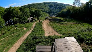
more stats
1.1 miles
Distance
14 ft
Climb
-567 ft
Descent
00:08:55
Avg time
-555 ft
Altitude change
963 ft
Altitude min
1,518 ft
Altitude max
1,518 ft
Altitude start
965 ft
Altitude end
-9.5%
Grade
-31.8%
Grade max
11.5%
Grade min
253 ft
Distance climb
5,121 ft
Distance down
410 ft
Distance flat
00:08:55
Avg time

Flow Line Details

  • Activities
    • Mountain Bike
    • E-Bike
  • Riding Area
  • Difficulty Rating
  • Voted Difficulty
    Blue (3 votes)
  • Local Popularity
    60 in Mountain Biking [+]
    • 75 in E-Biking
  • Global Ranking
    #97487 in Mountain Biking [+]
    • #28861 in E-Biking
  • National Ranking
    #625 in Mountain Biking · Austria [+]
    • #199 in E-Biking
  • Trail Type
    Machine Groomed
  • Bike Type
    DH, AM, XC
  • Direction
    Downhill Only
    Popular Direction Shown
  • Physical Rating
    Moderate
  • Season
    spring-summer-fall
  • Dogs Allowed
    Yes
  • eBike Allowed
    Yes up to Class 1
  • TTFs on Trail
    Berm, Pump Track, Roller Coaster

flowy trail with small berms: good for beginners, but still a lot of fun for more advanced riders
no roots nor rocks - just flow

Access Info

open

Tags
BermsFlowyPump trackRollers

Local Trail Association

Recent Activity on Trail

Past Week
  • 1 rides
  • 20 miles average
6 Months
  • 9 rides
  • 30 miles avg distance
All
  • 130 rides
  • Last: Nov 1, 2026
c1c2c3c4
January
February
March
April
May
June
July
August
September
October
November
December
update trails status or condition

Flow Line Trail Reports

statusdatedescription
Nov 1, 2026 @ 12:47pm (Europe/Vienna)
Nov 1, 2026
Mit 1. November endet die vertragliche Erlaubnis für Mountainbiken im Wald und alle Strecken sind bis 1.3.2027 aufgrund des Forstgesetzes gesperrt.
Jul 10, 2026 @ 10:08am (Europe/Vienna)
Jul 10, 2026
Forstarbeiten sind beendet und der Trail ist wieder frei. Wie alle Trails zur Zeit ziemlich trocken und teilweise dadurch rutschig.
Jun 30, 2026 @ 10:58am (Europe/Vienna)
Jun 30, 2026
Aufgrund von Forstarbeiten neben der Strecke muss die Flow Line leider gesperrt werden. Wir haben leider noch keine Information wie lange die...
Mar 9, 2026 @ 10:38am (Europe/Vienna)
Mar 9, 2026
Trail ist geöffnet nur noch voll mit Laub. Nächstes Wochenende sollte auch das entfernt werden.
Mar 3, 2026 @ 10:10am (Europe/Vienna)
Mar 3, 2026
Aufgrund von Forstarbeiten neben und auf der Strecke muss die Flow Line noch gesperrt bleiben. Sobald die Arbeiten abgeschlossen sind und die...
more »
Status:
on Nov 1, 2026
Variable
Avg: 3.78 (8 votes)
Your vote: 0

view (865)
close
      Directions to flow-line-63751 trailhead (48.273250, 16.246260)

      Photos

      1 more »
      mtb
      183 |
      Aug 14, 2019 @ 3:54am
      Aug 14, 2019

      Videos

      3 more »
      youtuber Flow Line Mountain Bike Trail  2021 |...
      mtb
      5:07 | 601 | Jul 8, 2021 , Vienna
      MTB gem: TrailCenter Wien
      mtb
      7:47 | 134 | May 18, 2024 , Vienna
      Illegal trail Maribor
      mtb
      9:49 | 894 | Jun 26, 2011 , Vienna
      3.7 ★★★★★
      8 Ratings
      5 ★ 13%
      4 ★ 50%
      3 ★ 25%
      2 ★ 13%
      1 ★

      3 Reviews & Comments

      Rich-since78
      Top Zustand - dirt und da ist zu Saisonende der eine oder andere Anlieger nicht mehr top-opt - aber alles in allem 1A
      Mad112
      02.10.2021 Flowline ist leider in sehr schlechtem Zustand zZ nichts für ungeübte / Anfänger oder Kinder..viel Wurzeln ..sehr Hart und Anliger tw in sehr schlechtem zustand ..da sollten x die Shaper rann.. Aber für alle anderen problemlos zu fahren
      kenspeed
      My first time on a downhill trail. I have a KTM XC bike with thin tyres - lower the saddle and lower the tyre pressure and it managed fine. I on the other hand was clutching on for dear life. Maybe next time will be more successful!

      We hope you've been enjoying Trailforks!

      Create a FREE account to view all trail reviews and much more.

      • By sendo & contributors
      • #63751 - 2,700 views

      Frequently Asked Questions

      ▼ Where is Flow Line located?
      Flow Line is located in Trail-Area Wien Nord, Vienna, Austria. It is part of the Trail-Area Wien Nord trail network. The trailhead is located at coordinates 48.27325, 16.24626.
      ▼ How hard is Flow Line?
      Flow Line is rated as Blue difficulty. The physical rating is Moderate. The average grade is 9.5%.
      ▼ What is the elevation gain for Flow Line?
      Flow Line has 14 ft of elevation gain. The trail has 567 ft of elevation descent. The elevation ranges from 963 ft to 1,518 ft.
      ▼ Is Flow Line a point to point trail?
      Yes, Flow Line is a point to point trail. The direction is Downhill Only. The trail type is machine groomed.
      ▼ How long is Flow Line?
      Flow Line is 1.1 miles long. The trail type is machine groomed.
      ▼ Are dogs allowed on Flow Line?
      Yes, dogs are allowed on Flow Line. Please keep dogs on a leash where required and clean up after them.
      ▼ When is the best time of year to ride Flow Line?
      Based on activity log data, the most popular months to ride Flow Line are:
      • August (6 activities)
      • April (4 activities)
      • May (4 activities)
      Check the reports page for current trail conditions.
      ▼ How do I access Flow Line? Where is the closest parking trailhead?
      The closest parking and trailhead locations to Flow Line are: View all parking locations in the area.
      ▼ How long does it take to ride Flow Line?
      Based on recorded activities, it takes an average of 9 minutes to ride Flow Line. The trail is 1.1 miles long. Actual times will vary based on fitness level, conditions, and pace. View recent activity logs for more details.
      ▼ How busy is Flow Line?
      Flow Line is a moderately popular trail. There have been 715 recorded activities on this trail. The trail has received 865 check-ins. View recent activity on this trail.

      Hit the Trail

      Open in App

      Get this trail on your phone instantly.

      open trail in app

      Download Trail

      Save to wishlist, Garmin & download.
      save the trail

      Find Related Routes

      Find routes and users activities that include this trail.
      find routes for this trail

      You must enter a description before submitting.