more stats
1,923 ft
Distance
-272 ft
Descent
00:01:36
Avg time
-272 ft
Altitude change
4,319 ft
Altitude min
4,591 ft
Altitude max
4,591 ft
Altitude start
4,321 ft
Altitude end
-14.1%
Grade
-39.7%
Grade max
1.2%
Grade min
174 ft
Distance climb
1,749 ft
Distance down
00:01:36
Avg time

Flow Link Details

  • Activities
    • Mountain Bike
    • E-Bike
  • Riding Area
  • Ref Number
    L5
  • Difficulty Rating
  • Voted Difficulty
    Secondary Access Road/Trail (2 votes)
  • Local Popularity
    100 in Mountain Biking [+]
    • 100 in E-Biking
  • Global Ranking
    #938 in Mountain Biking [+]
    • #3599 in E-Biking
  • Trail Type
    Other
  • Bike Type
    AM
  • Direction
    Downhill Only
    Popular Direction Shown
  • eBike Allowed
    Yes up to Class 1
  • Land Owner

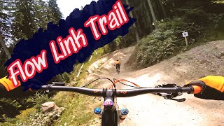
Schlängelt sich durch den Wald in Richtung Mittelstation Asitz. Der Flow Link lässt die freie Wahl – Airtime oder doch am Boden bleiben – und ist gespickt mit variablen Takeoffs, Step-downs, Tables und Berms.

Snakes through the forest towards the mid station of the Asitz. The Flow Link gives you the freedom of choice – airtime or stay on the ground – and is peppered with variable take-offs, step-downs, tables and berms.

Bike Park

Recent Activity on Trail

Past Week
  • 14 rides
  • 29 miles average
6 Months
  • 73 rides
  • 28 miles avg distance
All
  • 773 rides
  • Last: Jun 24, 2026
c1c2c3c4
January
February
March
April
May
June
July
August
September
October
November
December
update trails status or condition

Flow Link Trail Reports

statusdatedescription
Jun 24, 2026 @ 11:06am (Europe/Ljubljana)
23 hours
Jan 10, 2026 @ 9:22am (Europe/Vienna)
Jan 10, 2026
Closed, Winterbetrieb bzw. Wintersperre. Vrsl. Öffnung der Bikepark-Saison 2026: 8. - 14. Mai 2026
Sep 7, 2025 @ 8:29am
Sep 7, 2025
Ok
Sep 6, 2025 @ 8:44am
Sep 6, 2025
Sep 4, 2025 @ 11:37am
Sep 4, 2025
more »
Status:
on Jun 24, 2026
Ideal
Avg: 4.16 (34 votes)
Your vote: 0

view (11,535)
close
3D
Trail Conditions
  • Unknown
  • Snow Groomed
  • Snow Packed
  • Snow Covered
  • Snow Cover Partial
  • Freeze/thaw Cycle
  • Icy
  • Prevalent Mud
  • Wet
  • Variable
  • Ideal
  • Dry
  • Very Dry
Trail Flow (Ridden Direction)
Trailforks scans users ridelogs to determine the most popular direction each trail is ridden. A good flowing trail network will have most trails flowing in a single direction according to their intension.
The colour categories are based on what percentage of riders are riding a trail in its intended direction.
  • > 96%
  • > 90%
  • > 80%
  • > 70%
  • > 50%
  • < 50%
  • bi-directional trail
  • no data
Trail Last Ridden
Trailforks scans ridelogs to determine the last time a trail was ridden.
  • < 2 days
  • < 1 week
  • < 2 weeks
  • < 1 month
  • < 6 months
  • > 6 months
Trail Ridden Direction
The intended direction a trail should be ridden.
  • Downhill Only
  • Downhill Primary
  • Both Directions
  • Uphill Primary
  • Uphill Only
  • One Direction
Contribute Details
Colors indicate trail is missing specified detail.
  • Description
  • Photos
  • Description & Photos
  • Videos
Trail Popularity ?
Trailforks scans ridelogs to determine which trails are ridden the most in the last 9 months. Trails are compared with nearby trails in the same city region with a possible 25 colour shades. Think of this as a heatmap, more rides = more kinetic energy = warmer colors.
  • most popular
  • popular
  • less popular
  • not popular
ATV/ORV/OHV Filter
Max Vehicle Width
inches
US Cell Coverage
Legend
cell carrier legend

Radar Time
Activity Recordings
Trailforks uses anonymized public activity data. ?
Activity Recordings
Trailforks uses anonymized public activity data. ?
Personal Heatmap
Activity Types
all / none
Options
2
Date range month
Winter Trails
Warning A routing network for winter maps does not exist. Selecting trails using the winter trails layer has been disabled.
Missing Trails
Most Popular
Least Popular
Trails are colored based on popularity. The more popular a trail is, the more red. Less popular trails trend towards green.
Jump Magnitude Heatmap
Heatmap of where riders jump on trails. Zoom in to see individual jumps, click circles to view jump details.
BC Backroad Status

Service Road Atlas is a free to use, community-driven service for viewing and creating reports on the numerous back-country service roads around B.C. and Alberta.

map legend
Slope Aspect
Direction the slope faces
Flat N NE E SE S SW W NW
Trails Deemphasized
Trails are shown in grey.
disable
Only show trails with no bike usage.
Enable
Suggested Layers
Based on selected activity type

    Save the current map location and zoom level as your default home location whenever this page is loaded.

    Save
        Directions to flow-link trailhead (47.422640, 12.715060)

        Photos

        No photos have been added for Flow Link yet, add a photo.

        Videos

        6 more »
        youtuber Flow Link | Red Graded Leogang Trail (L5) |...
        0:46 | 87 | Aug 27, 2025 , Leogang
        Leogang Bikepark - Red Trail \ Flow Link- L05
        0:16 | 110 | Jan 5, 2025 , Leogang
        Flow Link - Bike Park Leogang - 2024
        0:28 | 131 | Jul 15, 2024 , Leogang
        Hangman + Flow link | Saalbach Hinterglemm...
        5:49 | 144 | Jul 15, 2023 , Leogang

        Routes with this trail

        41 miles 14,180 ft 8 Loop Race
        UCI Enduro World Cup COURSE STATS Length: 66.79 km +1000m Pedal +4120m Gondola -5030m Stages S1 Bergstadl...

        Reviews / Comments

        No reviews yet, be the first to write a review or ask a question.
        Use trail reports to comment on trail conditions.


        We hope you've been enjoying Trailforks!

        Create a FREE account to view trail comments and much more.

        • By DaniLBB BPLG & contributors
        • #103636 - 2,290 views

        Frequently Asked Questions About Flow Link

        Where is Flow Link located?
        Flow Link is located in The EPIC Bikepark Leogang, Leogang, Austria. It is part of the The EPIC Bikepark Leogang trail network. The trailhead is located at coordinates 47.42264, 12.71506.
        How hard is Flow Link?
        Flow Link is rated as Red difficulty. The average grade is 14.1%.
        What is the elevation gain for Flow Link?
        The trail has 272 ft of elevation descent. The elevation ranges from 4,319 ft to 4,591 ft.
        Is Flow Link a point to point trail?
        Yes, Flow Link is a point to point trail. The direction is Downhill Only. The trail type is other.

        Hit the Trail

        Open in App

        Get this trail on your phone instantly.
        open trail in app

        Download Trail

        Save to wishlist, Garmin & download.
        save the trail

        Find Related Routes

        Find routes and users activities that include this trail.
        find routes for this trail

        You must enter a description before submitting.