more stats
2,841 ft
Distance
-326 ft
Descent
00:11:38
Avg time
-327 ft
Altitude change
167 ft
Altitude min
494 ft
Altitude max
494 ft
Altitude start
167 ft
Altitude end
-11.5%
Grade
-30.6%
Grade max
0.9%
Grade min
2,713 ft
Distance down
00:11:38
Avg time

Flowdacious Details

  • Activities
    • Mountain Bike
    • Adaptive Bike
    • Winter Fat Bike
    • Hike
    • Trail Running
  • Riding Area
    Spring Mountain Adventures
    Schwenksville, Pennsylvania
  • Difficulty Rating
  • Local Popularity
    75 in Mountain Biking [+]
    • 80 in Trail Running
    • 5 in Hiking
  • Global Ranking
    #87502 in Mountain Biking [+]
    • #70979 in Trail Running
    • #243836 in Hiking
  • Trail Type
    Singletrack
  • Bike Type
    DH, AM, XC, DJ, RD, Fat, Adaptive MTB, CX
  • Season
    April - Novmber
  • Dogs Allowed
    Yes
  • TTFs on Trail
    Bridge, Drop, Jump, Gap Jump, Rock Face, Rock Garden
  • Year Opened
    2018

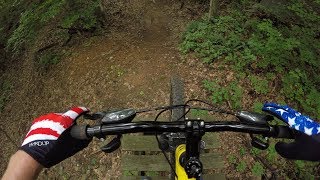
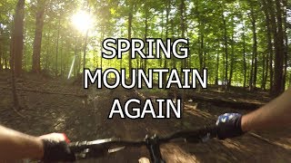
Flowdacious starts similarly as several other trails at Spring mountain, at the top of the Stonehill chairlift. Flowdacious is comprised of several of Spring Mountain's infamous features such as the 'pit-drop' or 'toilet bowl' and then naviagtes through some flowy berms, more rock drops traversing the mountain several times.

Traditionally Indigenous Territory

Recent Activity on Trail

Past Week
  • 1 rides
  • 8 miles average
6 Months
  • 11 rides
  • 4 miles avg distance
All
  • 114 rides
  • Last: Jun 16, 2026
c1c2c3c4
January
February
March
April
May
June
July
August
September
October
November
December
update trails status or condition

Flowdacious Trail Reports

statusdatedescription
May 20, 2025 @ 3:35pm
May 20, 2025
Jul 19, 2024 @ 4:24am
Jul 19, 2024
Overall maintenance is needed.
Sep 6, 2023 @ 11:04am
Sep 6, 2023
Jun 6, 2023 @ 10:33am
Jun 6, 2023
Apr 4, 2020 @ 9:40am
Apr 4, 2020
Trail in great shape. Trail crew out shaping lips and filling in landings
more »
Status:
on May 20, 2025
Ideal
Avg: 4.35 (5 votes)
Your vote: 0

view (1,188)
close
3D
Trail Conditions
  • Unknown
  • Snow Groomed
  • Snow Packed
  • Snow Covered
  • Snow Cover Partial
  • Freeze/thaw Cycle
  • Icy
  • Prevalent Mud
  • Wet
  • Variable
  • Ideal
  • Dry
  • Very Dry
Trail Flow (Ridden Direction)
Trailforks scans users ridelogs to determine the most popular direction each trail is ridden. A good flowing trail network will have most trails flowing in a single direction according to their intension.
The colour categories are based on what percentage of riders are riding a trail in its intended direction.
  • > 96%
  • > 90%
  • > 80%
  • > 70%
  • > 50%
  • < 50%
  • bi-directional trail
  • no data
Trail Last Ridden
Trailforks scans ridelogs to determine the last time a trail was ridden.
  • < 2 days
  • < 1 week
  • < 2 weeks
  • < 1 month
  • < 6 months
  • > 6 months
Trail Ridden Direction
The intended direction a trail should be ridden.
  • Downhill Only
  • Downhill Primary
  • Both Directions
  • Uphill Primary
  • Uphill Only
  • One Direction
Contribute Details
Colors indicate trail is missing specified detail.
  • Description
  • Photos
  • Description & Photos
  • Videos
Trail Popularity ?
Trailforks scans ridelogs to determine which trails are ridden the most in the last 9 months. Trails are compared with nearby trails in the same city region with a possible 25 colour shades. Think of this as a heatmap, more rides = more kinetic energy = warmer colors.
  • most popular
  • popular
  • less popular
  • not popular
ATV/ORV/OHV Filter
Max Vehicle Width
inches
US Cell Coverage
Legend
cell carrier legend

Radar Time
Activity Recordings
Trailforks uses anonymized public activity data. ?
Activity Recordings
Trailforks uses anonymized public activity data. ?
Personal Heatmap
Activity Types
all / none
Options
2
Date range month
Winter Trails
Warning A routing network for winter maps does not exist. Selecting trails using the winter trails layer has been disabled.
Missing Trails
Most Popular
Least Popular
Trails are colored based on popularity. The more popular a trail is, the more red. Less popular trails trend towards green.
Jump Magnitude Heatmap
Heatmap of where riders jump on trails. Zoom in to see individual jumps, click circles to view jump details.
BC Backroad Status

Service Road Atlas is a free to use, community-driven service for viewing and creating reports on the numerous back-country service roads around B.C. and Alberta.

map legend
Slope Aspect
Direction the slope faces
Flat N NE E SE S SW W NW
Trails Deemphasized
Trails are shown in grey.
disable
Only show trails with no bike usage.
Enable
Suggested Layers
Based on selected activity type

    Save the current map location and zoom level as your default home location whenever this page is loaded.

    Save
        Directions to flowdacious trailhead (40.268550, -75.456310)

        Photos

        6 more »
        559 |
        Aug 13, 2020 @ 5:40pm
        Aug 13, 2020
        322 |
        Aug 11, 2020 @ 4:41pm
        Aug 11, 2020
        327 |
        Aug 11, 2020 @ 4:41pm
        Aug 11, 2020
        418 |
        Jul 16, 2013 @ 10:06am
        Jul 16, 2013

        Videos

        7 more »
        youtuber Spring Mountain Trail Guide Part 1
        14:28 | 460 | Jan 23, 2019 , Schwenksville
        youtuber Spring Mountain Again
        11:49 | 576 | Jan 23, 2019 , Schwenksville
        youtuber Flowdacious Wishlist
        5:04 | 618 | Nov 22, 2019 , Schwenksville
        20 Foot Step-Down on Flowdacious
        0:05 | 542 | Oct 30, 2020 , Schwenksville

        Reviews / Comments

        No reviews yet, be the first to write a review or ask a question.
        Use trail reports to comment on trail conditions.


        We hope you've been enjoying Trailforks!

        Create a FREE account to view trail comments and much more.

        • By cbarth & contributors
        • #128473 - 2,357 views

        Frequently Asked Questions About Flowdacious

        Where is Flowdacious located?
        Flowdacious is located in Spring Mountain Adventures, Schwenksville, Pennsylvania, United States. It is part of the Spring Mountain Adventures trail network. The trailhead is located at coordinates 40.26855, -75.45631.
        How hard is Flowdacious?
        Flowdacious is rated as Black Diamond difficulty. The average grade is 11.5%.
        What is the elevation gain for Flowdacious?
        The trail has 326 ft of elevation descent. The elevation ranges from 167 ft to 494 ft.
        How long is Flowdacious?
        Flowdacious is 2,841 ft long. The trail type is singletrack.

        Hit the Trail

        Open in App

        Get this trail on your phone instantly.
        open trail in app

        Download Trail

        Save to wishlist, Garmin & download.
        save the trail

        Find Related Routes

        Find routes and users activities that include this trail.
        find routes for this trail

        You must enter a description before submitting.