
Open in App
Get this trail on your phone instantly.

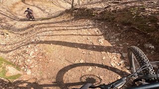
A smooth, flowing piece of singletrack with over 100 berms and long swooping descents that holds some of CAMBA's most famous features. 38 Special is full of banked drops and rollers, climb to the highest point on the world famous Birkebeiner Ski Trail, take a couple laps in the Gravity Cavity a banked slalom run through a valley, plus the 180 foot River Pig.
| c1 | c2 | c3 | c4 |
|---|---|---|---|
January | February | March | April |
May | June | July | August |
September | October | November | December |

Service Road Atlas is a free to use, community-driven service for viewing and creating reports on the numerous back-country service roads around B.C. and Alberta.
Save the current map location and zoom level as your default home location whenever this page is loaded.
Save Berm Berm Berm Berm Berm Berm Berm Berm Berm Berm Berm Berm Berm Berm Berm Berm Berm Berm Berm Berm Berm Berm Berm Berm Berm Berm Berm Berm Berm Berm Berm Berm Berm Berm Berm Berm Berm Berm Bridge Drop Wallride
 Jump Jump Jump Jump Jump Jump Jump
 Pump Track Pump Track Pump Track Pump Track Berm Pump Track Pump Track Pump Track Skinny Drop Rock Garden Jump Jump
  Wallride Jump
We hope you've been enjoying Trailforks!
Create a FREE account to view trail comments and much more.
You must enter a description before submitting.

