more stats
2,047 ft
Distance
-131 ft
Descent
00:02:08
Avg time
-131 ft
Altitude change
1,119 ft
Altitude min
1,250 ft
Altitude max
1,250 ft
Altitude start
1,119 ft
Altitude end
-6.4%
Grade
-15.4%
Grade max
-0.8%
Grade min
1,959 ft
Distance down
39 ft
Distance flat
00:02:08
Avg time

FlowSenglar Details

  • Activities
    • Mountain Bike
    • E-Bike
    • Hike
    • Trail Running
  • Riding Area
    La Plana Alta
    Vilanova D'Alcolea
  • Difficulty Rating
  • Local Popularity
    95 in Mountain Biking [+]
    • 100 in E-Biking
    • 5 in Trail Running
    • 5 in Hiking
  • Global Ranking
    #4937 in Mountain Biking [+]
    • #8508 in E-Biking
    • #185209 in Trail Running
    • #184928 in Hiking
  • Trail Type
    Singletrack
  • Bike Type
    AM, XC
  • Direction
    Downhill Primary
    Popular Direction Shown
  • Climb Difficulty
    Blue
  • Physical Rating
    Easy
  • Trail Visibility
    Sometimes hard to follow
  • Dogs Allowed
    Yes
  • eBike Allowed
    Yes up to Class 1
  • TTFs on Trail
    Drop

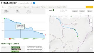
Senda que discurre por antiguos campos de cultivo abandonados y abancalados, aprovechando sus antiguas conexiones para enlazarlos. Suelo arenoso en perfecto estado. Zona muy húmeda, lo que haceque el entorno sea muy selvático. Se puede remontar, y es una gran conexión con la senda Mas de Tarragó. Abierta el 21-10-2022.

Local Trail Association

Recent Activity on Trail

Past Week
  • 0 rides
  •  
6 Months
  • 6 rides
  • 21 miles avg distance
All
  • 62 rides
  • Last: Apr 11, 2026
c1c2c3c4
January
February
March
April
May
June
July
August
September
October
November
December
Status:
on May 31, 2026
Ideal
Avg: 4.39 (4 votes)
Your vote: 0

view (237)
close
3D
Trail Conditions
  • Unknown
  • Snow Groomed
  • Snow Packed
  • Snow Covered
  • Snow Cover Partial
  • Freeze/thaw Cycle
  • Icy
  • Prevalent Mud
  • Wet
  • Variable
  • Ideal
  • Dry
  • Very Dry
Trail Flow (Ridden Direction)
Trailforks scans users ridelogs to determine the most popular direction each trail is ridden. A good flowing trail network will have most trails flowing in a single direction according to their intension.
The colour categories are based on what percentage of riders are riding a trail in its intended direction.
  • > 96%
  • > 90%
  • > 80%
  • > 70%
  • > 50%
  • < 50%
  • bi-directional trail
  • no data
Trail Last Ridden
Trailforks scans ridelogs to determine the last time a trail was ridden.
  • < 2 days
  • < 1 week
  • < 2 weeks
  • < 1 month
  • < 6 months
  • > 6 months
Trail Ridden Direction
The intended direction a trail should be ridden.
  • Downhill Only
  • Downhill Primary
  • Both Directions
  • Uphill Primary
  • Uphill Only
  • One Direction
Contribute Details
Colors indicate trail is missing specified detail.
  • Description
  • Photos
  • Description & Photos
  • Videos
Trail Popularity ?
Trailforks scans ridelogs to determine which trails are ridden the most in the last 9 months. Trails are compared with nearby trails in the same city region with a possible 25 colour shades. Think of this as a heatmap, more rides = more kinetic energy = warmer colors.
  • most popular
  • popular
  • less popular
  • not popular
ATV/ORV/OHV Filter
Max Vehicle Width
inches
US Cell Coverage
Legend
cell carrier legend

Radar Time
Activity Recordings
Trailforks uses anonymized public activity data. ?
Activity Recordings
Trailforks uses anonymized public activity data. ?
Personal Heatmap
Activity Types
all / none
Options
2
Date range month
Winter Trails
Warning A routing network for winter maps does not exist. Selecting trails using the winter trails layer has been disabled.
Missing Trails
Most Popular
Least Popular
Trails are colored based on popularity. The more popular a trail is, the more red. Less popular trails trend towards green.
Jump Magnitude Heatmap
Heatmap of where riders jump on trails. Zoom in to see individual jumps, click circles to view jump details.
BC Backroad Status

Service Road Atlas is a free to use, community-driven service for viewing and creating reports on the numerous back-country service roads around B.C. and Alberta.

map legend
Slope Aspect
Direction the slope faces
Flat N NE E SE S SW W NW
Trails Deemphasized
Trails are shown in grey.
disable
Only show trails with no bike usage.
Enable
Suggested Layers
Based on selected activity type

    Save the current map location and zoom level as your default home location whenever this page is loaded.

    Save
        Directions to flowsenglar trailhead (40.252000, 0.100850)

        Photos

        1 more »
        31 |
        Aug 10, 2024 @ 1:21pm
        Aug 10, 2024
        45 |
        Apr 17, 2023 @ 11:43pm
        Apr 17, 2023
        46 |
        Apr 17, 2023 @ 11:43pm
        Apr 17, 2023
        45 |
        Apr 17, 2023 @ 11:43pm
        Apr 17, 2023

        Videos

        2 more »
        SENDA FLOW SENGLAR ( Vilanova )4K
        2:15 | 57 | Jan 7, 2025 , Vilanova D'Alcolea
        FlowSenglar
        2:47 | 149 | Oct 21, 2022 , Vilanova D'Alcolea

        Routes with this trail

        5.0 25 miles 3,741 ft 28 Loop
        Ruta con punto de partida en Les Coves de Vinroma , muy parecida a una ya existente llamada el tour dels...
        36 miles 5,256 ft 40 Out & Back
        La Ruta El Tour dels Tobogans es una ruta que comienza en Coves de Vinroma se divide en 3 etapas en las...
        27 miles 3,892 ft 34 Out & Back
        La Ruta EL DRACK DE LA PLANA ALTA consta de unos 43 km parte des de Vilanova y termina en el punto de...

        1 Review & Comments


        We hope you've been enjoying Trailforks!

        Create a FREE account to view trail comments and much more.

        • By architrepaTF Pro TFSPAIN & contributors
        • #580595 - 392 views

        Frequently Asked Questions About FlowSenglar

        Where is FlowSenglar located?
        FlowSenglar is located in La Plana Alta, Vilanova D'Alcolea, Spain. It is part of the La Plana Alta trail network. The trailhead is located at coordinates 40.252, 0.10085.
        How hard is FlowSenglar?
        FlowSenglar is rated as Blue difficulty. The physical rating is Easy. The average grade is 6.4%. The climb difficulty is rated Blue.
        What is the elevation gain for FlowSenglar?
        The trail has 131 ft of elevation descent. The elevation ranges from 1,119 ft to 1,250 ft.
        Is FlowSenglar a point to point trail?
        FlowSenglar is not a point to point trail. The direction is Downhill Primary. The trail type is singletrack.

        Hit the Trail

        Open in App

        Get this trail on your phone instantly.
        open trail in app

        Download Trail

        Save to wishlist, Garmin & download.
        save the trail

        Find Related Routes

        Find routes and users activities that include this trail.
        find routes for this trail

        You must enter a description before submitting.