more stats
3,140 ft
Distance
10 ft
Climb
-245 ft
Descent
00:06:56
Avg time
-235 ft
Altitude change
326 ft
Altitude min
561 ft
Altitude max
561 ft
Altitude start
325 ft
Altitude end
-7.5%
Grade
-31%
Grade max
8.7%
Grade min
279 ft
Distance climb
2,661 ft
Distance down
151 ft
Distance flat
00:06:56
Avg time

Flowtopia Details

  • Activities
    • Mountain Bike
    • E-Bike
  • Riding Area
    Goat Farm
    Greenmount
  • Ref Number
    Trail3
  • Difficulty Rating
  • Local Popularity
    95 in Mountain Biking [+]
    • 90 in E-Biking
  • Global Ranking
    #747 in Mountain Biking [+]
    • #15005 in E-Biking
  • Trail Type
    Machine Groomed
  • Bike Type
    DH, AM, XC
  • Direction
    Downhill Only
    Popular Direction Shown
  • Physical Rating
    Moderate
  • Trail Visibility
    Always easy to follow
  • eBike Allowed
  • TTFs on Trail
    Berm, Jump, Gap Jump
  • Year Opened
    2021

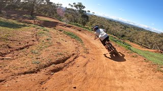
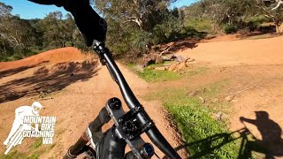
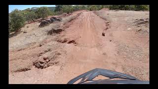
Flowtopia is a blue flow trail, big supportive berms, table tops and some small gaps which are rollable if you go slow.

Access Info

Access from the top of the hill behind the nipple, Entry to this trail is on the left after taking the Green up (Wifly).

Disclaimer

Pre-ride, re-ride & Free ride! Ride at your own risk and check features; do not just hit stuff blind.

Trail Supporters
  • Three Chillies Design
    Builder
Local Trail Association
Traditionally Indigenous Territory

Recent Activity on Trail

Past Week
  • 0 rides
  •  
6 Months
  • 17 rides
  • 5 miles avg distance
All
  • 407 rides
  • Last: Jun 20, 2026
c1c2c3c4
January
February
March
April
May
June
July
August
September
October
November
December
update trails status or condition

Flowtopia Trail Reports

statusdatedescription
May 21, 2026 @ 4:15pm (Australia/Perth)
May 21, 2026
Sep 21, 2025 @ 8:16am (Australia/Perth)
Sep 20, 2025
Slightly gravely but good condition.
Jul 13, 2025 @ 3:06am
Jul 13, 2025
recent maintainence on first three quarters of trail very good,no brake bumps...
Mar 30, 2025 @ 12:47am
Mar 30, 2025
brake bumps on berms please slow down
Sep 1, 2024 @ 6:40am
Sep 1, 2024
more »
Status:
on May 21, 2026
Dry
Avg: 4.32 (3 votes)
Your vote: 0

view (4,690)
close
3D
Trail Conditions
  • Unknown
  • Snow Groomed
  • Snow Packed
  • Snow Covered
  • Snow Cover Partial
  • Freeze/thaw Cycle
  • Icy
  • Prevalent Mud
  • Wet
  • Variable
  • Ideal
  • Dry
  • Very Dry
Trail Flow (Ridden Direction)
Trailforks scans users ridelogs to determine the most popular direction each trail is ridden. A good flowing trail network will have most trails flowing in a single direction according to their intension.
The colour categories are based on what percentage of riders are riding a trail in its intended direction.
  • > 96%
  • > 90%
  • > 80%
  • > 70%
  • > 50%
  • < 50%
  • bi-directional trail
  • no data
Trail Last Ridden
Trailforks scans ridelogs to determine the last time a trail was ridden.
  • < 2 days
  • < 1 week
  • < 2 weeks
  • < 1 month
  • < 6 months
  • > 6 months
Trail Ridden Direction
The intended direction a trail should be ridden.
  • Downhill Only
  • Downhill Primary
  • Both Directions
  • Uphill Primary
  • Uphill Only
  • One Direction
Contribute Details
Colors indicate trail is missing specified detail.
  • Description
  • Photos
  • Description & Photos
  • Videos
Trail Popularity ?
Trailforks scans ridelogs to determine which trails are ridden the most in the last 9 months. Trails are compared with nearby trails in the same city region with a possible 25 colour shades. Think of this as a heatmap, more rides = more kinetic energy = warmer colors.
  • most popular
  • popular
  • less popular
  • not popular
ATV/ORV/OHV Filter
Max Vehicle Width
inches
US Cell Coverage
Legend
cell carrier legend

Radar Time
Activity Recordings
Trailforks uses anonymized public activity data. ?
Activity Recordings
Trailforks uses anonymized public activity data. ?
Personal Heatmap
Activity Types
all / none
Options
2
Date range month
Winter Trails
Warning A routing network for winter maps does not exist. Selecting trails using the winter trails layer has been disabled.
Missing Trails
Most Popular
Least Popular
Trails are colored based on popularity. The more popular a trail is, the more red. Less popular trails trend towards green.
Jump Magnitude Heatmap
Heatmap of where riders jump on trails. Zoom in to see individual jumps, click circles to view jump details.
BC Backroad Status

Service Road Atlas is a free to use, community-driven service for viewing and creating reports on the numerous back-country service roads around B.C. and Alberta.

map legend
Slope Aspect
Direction the slope faces
Flat N NE E SE S SW W NW
Trails Deemphasized
Trails are shown in grey.
disable
Only show trails with no bike usage.
Enable
Suggested Layers
Based on selected activity type

    Save the current map location and zoom level as your default home location whenever this page is loaded.

    Save
        Directions to flowtopia trailhead (-31.906420, 116.057580)

        Photos

        7 more »
        84 |
        Aug 19, 2023 @ 5:11am
        Aug 19, 2023
        117 |
        Oct 6, 2021 @ 5:14am
        Oct 6, 2021
        194 |
        Aug 15, 2021 @ 10:11pm
        Aug 15, 2021
        190 |
        Jul 5, 2021 @ 2:48am
        Jul 5, 2021

        Videos

        5 more »
        Flow + cheeky line Flowtopia @ The Goat Farm...
        0:39 | 281 | Jun 24, 2024 , Greenmount
        youtuber The Goat Farm MTB Park - Flowtopia
        0:55 | 401 | Dec 11, 2023 , Greenmount
        Flowtopia:::GOAT FARM.PERTH.AUSTRALIA
        0:14 | 781 | Jan 2, 2022 , Greenmount
        The Goat Farm MTB Park Checking out the new...
        5:53 | 796 | May 30, 2021 , Greenmount

        1 Review & Comments


        We hope you've been enjoying Trailforks!

        Create a FREE account to view trail comments and much more.

        • By TimNeveMTBCoachTF Pro & contributors
        • #428791 - 3,091 views

        Frequently Asked Questions About Flowtopia

        Where is Flowtopia located?
        Flowtopia is located in Goat Farm, Greenmount, Australia. It is part of the Goat Farm trail network. The trailhead is located at coordinates -31.90648, 116.05761.
        How hard is Flowtopia?
        Flowtopia is rated as Blue difficulty. The physical rating is Moderate. The average grade is 7.4%.
        What is the elevation gain for Flowtopia?
        Flowtopia has 26 ft of elevation gain. The trail has 260 ft of elevation descent. The elevation ranges from 325 ft to 561 ft.
        Is Flowtopia a point to point trail?
        Yes, Flowtopia is a point to point trail. The direction is Downhill Only. The trail type is machine groomed.

        Hit the Trail

        Open in App

        Get this trail on your phone instantly.
        open trail in app

        Download Trail

        Save to wishlist, Garmin & download.
        save the trail

        Find Related Routes

        Find routes and users activities that include this trail.
        find routes for this trail

        You must enter a description before submitting.