



more stats
2.2 miles
Distance
34 ft
Climb
-770 ft
Descent
00:13:42
Avg time
-735 ft
Altitude change
5,916 ft
Altitude min
6,662 ft
Altitude max
6,651 ft
Altitude start
5,915 ft
Altitude end
-6.3%
Grade
-43.1%
Grade max
14.9%
Grade min
2,123 ft
Distance climb
1 mile
Distance down
1,598 ft
Distance flat
00:13:42
Avg time

Flume Details

  • Activities
    • Mountain Bike
    • E-Bike
    • Hike
    • Trail Running
  • Riding Area
    Bald Mountain Ephraim
    Ephraim, Utah
  • Difficulty Rating
  • Voted Difficulty
    Black Diamond (2 votes)
  • Local Popularity
    90 in Mountain Biking [+]
    • 100 in E-Biking
    • 90 in Trail Running
    • 90 in Hiking
  • Global Ranking
    #41418 in Mountain Biking [+]
    • #5901 in E-Biking
    • #136894 in Trail Running
    • #130658 in Hiking
  • Hiking SAC Scale
    T2 Mountain Hiking
  • Trail Type
    Singletrack
  • Bike Type
    DH, AM, Fat
  • Direction
    Downhill Primary
    Popular Direction Shown
  • Climb Difficulty
    Double Black Diamond
  • Physical Rating
    Moderate
  • Trail Visibility
    Always easy to follow
  • Season
    Summer
  • Dogs Allowed
    Yes
  • eBike Allowed
    Yes up to Class 1
  • TTFs on Trail
    Berm, Drop, Jump, Gap Jump, Ladder Bridge

Flume Trail
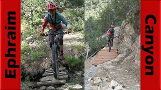
The Flume Trail offers a unique blend of easy cruising and technical challenge. The trail starts off fairly flat and easy, making for a relaxed and enjoyable beginning. Early on, you'll encounter a wooden boardwalk that guides you safely around a narrow turn. As you ride, take in the scenic views overlooking the beautiful Sanpete Valley.

However, don’t be fooled by the gentle start — the second half of the trail transforms into a black diamond descent that will test your skills as you drop into the valley below. Expect jumps along the way, adding excitement for advanced riders. The Flume Trail’s mix of mellow and technical sections makes it a memorable adventure for those ready for a challenge.

Access Info

Go up Ephraim Canyon Road and turn right at the A-frame cabin. Keep going up the double track and as you start up the "switchback" the trail starts on the right.

Recent Activity on Trail

Past Week
  • 1 rides
  • 13 miles average
6 Months
  • 13 rides
  • 10 miles avg distance
All
  • 102 rides
  • Last: Sep 15, 2026
c1c2c3c4
January
February
March
April
May
June
July
August
September
October
November
December
update trails status or condition

Flume Trail Reports

statusdatedescription
Jul 26, 2025 @ 9:49pm
Jul 26, 2025
Rad trail. Super loose given the conditions but I have to give credit to the builders.
May 12, 2024 @ 12:38pm
May 12, 2024
G2G
Aug 7, 2023 @ 11:29am
Aug 7, 2023
Pretty normal dry conditions. No issues.
Jun 3, 2023 @ 3:25pm
Jun 3, 2023
Jul 23, 2022 @ 5:26pm
Jul 23, 2022
more »
Status:
on Jul 26, 2025
Very Dry
Avg: 4.38 (14 votes)
Your vote: 0

view (657)
close
      Directions to flume trailhead (39.337600, -111.529000)

      Photos

      26 more »
      mtb
      124 |
      Jul 26, 2025 @ 10:43pm
      Jul 26, 2025
      mtb
      104 |
      Jul 26, 2025 @ 10:43pm
      Jul 26, 2025
      mtb
      96 |
      Jul 26, 2025 @ 10:43pm
      Jul 26, 2025
      mtb
      214 |
      Nov 24, 2021 @ 7:50am
      Nov 24, 2021

      Videos

      4 more »
      Broken Bridges & Epic Descent on Pioneer...
      mtb
      22:15 | 346 | Jul 6, 2022 , Ephraim
      Flume Trail
      mtb
      2:41 | 365 | Jan 18, 2018 , Ephraim
      Santa’s elf wrecking on a step up!!!
      mtb
      0:06 | 2879 | Dec 17, 2017 , Ephraim
      Flume Trail Crash
      mtb
      0:52 | 864 | Aug 25, 2014 , Ephraim

      Trail Lists

      Routes with this trail

      10 miles 375 ft 5 Shuttled
      Hit all the best routes in one drop. Trails are easy with everything from aspens to junipers.
      4.7
      14 Ratings
      5 64%
      4 36%
      3
      2
      1

      4 Reviews & Comments

      mtn-cycle-michael mtn-cycle-michael
      Rode it this last weekend. Super fun! Steep at the end but nothing too crazy, definitely a black flow trail, not very much tech.
      Santamtnbiker Santamtnbiker
      Could some one please tell me how to get people to confirm trails I’ve added?
      Santamtnbiker Santamtnbiker
      Snow packed and muddie. Might not be as bad since it’s warmed up, but last I rode it it was snow packed.

      We hope you've been enjoying Trailforks!

      Create a FREE account to view all trail reviews and much more.

      • By toddTF Pro Trailforks & contributors
      • #10807 - 4,163 views

      Frequently Asked Questions

      Where is Flume located?
      Flume is located in Bald Mountain Ephraim, Ephraim, Utah, United States. It is part of the Bald Mountain Ephraim trail network. The trailhead is located at coordinates 39.3376, -111.529.
      How hard is Flume?
      Flume is rated as Black Diamond difficulty. The physical rating is Moderate. The average grade is 6.3%. The climb difficulty is rated Double Black Diamond.
      What is the elevation gain for Flume?
      Flume has 34 ft of elevation gain. The trail has 770 ft of elevation descent. The elevation ranges from 5,916 ft to 6,662 ft.
      Is Flume a point to point trail?
      Flume is not a point to point trail. The direction is Downhill Primary. The trail type is singletrack.
      How long is Flume?
      Flume is 2.2 miles long. The trail type is singletrack.
      Are dogs allowed on Flume?
      Yes, dogs are allowed on Flume. Please keep dogs on a leash where required and clean up after them.
      When is the best time of year to ride Flume?
      Flume is best visited during: Summer.
      How do I access Flume? Where is the closest parking trailhead?
      The closest parking and trailhead locations to Flume are: View all parking locations in the area.
      How long does it take to ride Flume?
      Based on recorded activities, it takes an average of 13 minutes to ride Flume. The trail is 2.2 miles long. Actual times will vary based on fitness level, conditions, and pace. View recent activity logs for more details.
      How busy is Flume?
      Flume is a very popular trail. There have been 629 recorded activities on this trail. The trail has received 657 check-ins. View recent activity on this trail.

      Hit the Trail

      Open in App

      Get this trail on your phone instantly.

      open trail in app

      Download Trail

      Save to wishlist, Garmin & download.
      save the trail

      Find Related Routes

      Find routes and users activities that include this trail.
      find routes for this trail

      You must enter a description before submitting.



