more stats
1.2 miles
Distance
211 ft
Climb
-206 ft
Descent
00:09:00
Avg time
7 ft
Altitude change
4,481 ft
Altitude min
4,669 ft
Altitude max
4,662 ft
Altitude start
4,669 ft
Altitude end
0.1%
Grade
-14.8%
Grade max
69.2%
Grade min
2,569 ft
Distance climb
3,537 ft
Distance down
367 ft
Distance flat
00:09:00
Avg time

Friday Flat Details

  • Activities
    • Mountain Bike
    • E-Bike
  • Riding Area
  • Difficulty Rating
  • Local Popularity
    20 in Mountain Biking [+]
    • 15 in E-Biking
  • Global Ranking
    #118908 in Mountain Biking [+]
    • #102491 in E-Biking
  • Trail Type
    Singletrack
  • Bike Type
    XC
  • Direction
    One Direction
    Popular Direction Shown
  • Climb Difficulty
    Blue
  • Physical Rating
    Moderate
  • Trail Visibility
    Always easy to follow
  • eBike Allowed
    Yes up to Class 1

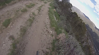
An easier cross country loop that is perfect for all levels. Starting at the Thredbo Valley Track trailhead, riders head into the forest traversing their way towards the opening of Friday Flat ski area. The undulating terrain takes you across bridges, through gum trees before a winding climb up the slopes to the Creek Station trail hub before they head back down the High Noon switchbacks. Friday Flat Loop also links the Thredbo Valley Track and Bridle Loop to the rest of the trail network.

Bike Park

Traditionally Indigenous Territory

Recent Activity on Trail

Past Week
  • 0 rides
  •  
6 Months
  • 1 rides
  • 31 miles avg distance
All
  • 82 rides
  • Last: Mar 7, 2026
c1c2c3c4
January
February
March
April
May
June
July
August
September
October
November
December
update trails status or condition

Friday Flat Trail Reports

statusdatedescription
Jun 9, 2026 @ 12:35pm (Australia/Sydney)
Jun 8, 2026
Bike Park Closed, See ya in November!
Apr 1, 2026 @ 11:53am (Australia/Sydney)
Mar 31, 2026
Jan 30, 2022 @ 9:52pm
Jan 30, 2022
All good, couple of puddles here and there but totally manageable, some construction materials on the track near the top.
Apr 12, 2021 @ 6:21pm
Apr 12, 2021
Nov 22, 2020 @ 11:11pm
Nov 22, 2020
more »
Status:
on Jun 9, 2026
Avg: 3.89 (4 votes)
Your vote: 0

view (1,457)
close
3D
Trail Conditions
  • Unknown
  • Snow Groomed
  • Snow Packed
  • Snow Covered
  • Snow Cover Partial
  • Freeze/thaw Cycle
  • Icy
  • Prevalent Mud
  • Wet
  • Variable
  • Ideal
  • Dry
  • Very Dry
Trail Flow (Ridden Direction)
Trailforks scans users ridelogs to determine the most popular direction each trail is ridden. A good flowing trail network will have most trails flowing in a single direction according to their intension.
The colour categories are based on what percentage of riders are riding a trail in its intended direction.
  • > 96%
  • > 90%
  • > 80%
  • > 70%
  • > 50%
  • < 50%
  • bi-directional trail
  • no data
Trail Last Ridden
Trailforks scans ridelogs to determine the last time a trail was ridden.
  • < 2 days
  • < 1 week
  • < 2 weeks
  • < 1 month
  • < 6 months
  • > 6 months
Trail Ridden Direction
The intended direction a trail should be ridden.
  • Downhill Only
  • Downhill Primary
  • Both Directions
  • Uphill Primary
  • Uphill Only
  • One Direction
Contribute Details
Colors indicate trail is missing specified detail.
  • Description
  • Photos
  • Description & Photos
  • Videos
Trail Popularity ?
Trailforks scans ridelogs to determine which trails are ridden the most in the last 9 months. Trails are compared with nearby trails in the same city region with a possible 25 colour shades. Think of this as a heatmap, more rides = more kinetic energy = warmer colors.
  • most popular
  • popular
  • less popular
  • not popular
ATV/ORV/OHV Filter
Max Vehicle Width
inches
US Cell Coverage
Legend
cell carrier legend

Radar Time
Activity Recordings
Trailforks uses anonymized public activity data. ?
Activity Recordings
Trailforks uses anonymized public activity data. ?
Personal Heatmap
Activity Types
all / none
Options
2
Date range month
Winter Trails
Warning A routing network for winter maps does not exist. Selecting trails using the winter trails layer has been disabled.
Missing Trails
Most Popular
Least Popular
Trails are colored based on popularity. The more popular a trail is, the more red. Less popular trails trend towards green.
Jump Magnitude Heatmap
Heatmap of where riders jump on trails. Zoom in to see individual jumps, click circles to view jump details.
BC Backroad Status

Service Road Atlas is a free to use, community-driven service for viewing and creating reports on the numerous back-country service roads around B.C. and Alberta.

map legend
Slope Aspect
Direction the slope faces
Flat N NE E SE S SW W NW
Trails Deemphasized
Trails are shown in grey.
disable
Only show trails with no bike usage.
Enable
Suggested Layers
Based on selected activity type

    Save the current map location and zoom level as your default home location whenever this page is loaded.

    Save
        Directions to friday-flat trailhead (-36.500130, 148.305090)

        Photos

        1 more »
        401 |
        Feb 24, 2008 @ 2:33am
        Feb 24, 2008

        Videos

        1 more »
        Thredbo All Mountain track run
        17:47 | 335 | Nov 30, 2015 , Thredbo

        Trail Lists

        1 Review & Comments


        We hope you've been enjoying Trailforks!

        Create a FREE account to view trail comments and much more.

        • By Jake-HannahTF Pro MPTA & contributors
        • #51444 - 2,810 views

        Frequently Asked Questions About Friday Flat

        Where is Friday Flat located?
        Friday Flat is located in Thredbo Bike Park, Thredbo, Australia. It is part of the Thredbo Bike Park trail network. The trailhead is located at coordinates -36.50013, 148.30509.
        How hard is Friday Flat?
        Friday Flat is rated as Blue difficulty. The physical rating is Moderate. The average grade is 0.1%. The climb difficulty is rated Blue.
        What is the elevation gain for Friday Flat?
        Friday Flat has 211 ft of elevation gain. The trail has 206 ft of elevation descent. The elevation ranges from 4,481 ft to 4,669 ft.
        Is Friday Flat a point to point trail?
        Yes, Friday Flat is a point to point trail. The direction is One Direction. The trail type is singletrack.

        Hit the Trail

        Open in App

        Get this trail on your phone instantly.
        open trail in app

        Download Trail

        Save to wishlist, Garmin & download.
        save the trail

        Find Related Routes

        Find routes and users activities that include this trail.
        find routes for this trail

        You must enter a description before submitting.