more stats
3,406 ft
Distance
-316 ft
Descent
00:05:34
Avg time
-316 ft
Altitude change
725 ft
Altitude min
1,041 ft
Altitude max
1,041 ft
Altitude start
725 ft
Altitude end
-9.3%
Grade
-17.9%
Grade max
-4.4%
Grade min
3,406 ft
Distance down
00:05:34
Avg time

Frog Combe Details

  • Activities
    • Mountain Bike
    • E-Bike
    • Hike
    • Trail Running
  • Riding Area
    Quantock Hills
    Taunton
  • Difficulty Rating
  • Local Popularity
    70 in Mountain Biking [+]
    • 70 in E-Biking
    • 75 in Trail Running
    • 5 in Hiking
  • Global Ranking
    #80989 in Mountain Biking [+]
    • #49460 in E-Biking
    • #65709 in Trail Running
    • #123924 in Hiking
  • Trail Type
    Singletrack
  • Bike Type
    AM, XC
  • Direction
    Downhill Primary
  • Dogs Allowed
    Yes
  • eBike Allowed
    Yes up to Class 1

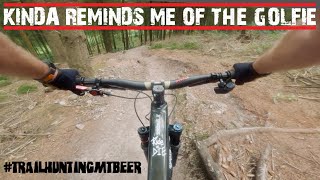
Fast grass entry in turning quickly into a very tricky roots section at the start, then a damp wide "roller coaster" track after wards.

You may notice a singletrack on the other side of the combe, which joins this trail at the stream crossing. To access this see Frog Combe Singletrack


Watch out for walkers.

Local Trail Association

Recent Activity on Trail

Past Week
  • 0 rides
  •  
6 Months
  • 13 rides
  • 14 miles avg distance
All
  • 66 rides
  • Last: Jun 16, 2026
c1c2c3c4
January
February
March
April
May
June
July
August
September
October
November
December
update trails status or condition

Frog Combe Trail Reports

Status:
on May 24, 2026
Variable
Avg: 4.24 (2 votes)
Your vote: 0

view (604)
close
3D
Trail Conditions
  • Unknown
  • Snow Groomed
  • Snow Packed
  • Snow Covered
  • Snow Cover Partial
  • Freeze/thaw Cycle
  • Icy
  • Prevalent Mud
  • Wet
  • Variable
  • Ideal
  • Dry
  • Very Dry
Trail Flow (Ridden Direction)
Trailforks scans users ridelogs to determine the most popular direction each trail is ridden. A good flowing trail network will have most trails flowing in a single direction according to their intension.
The colour categories are based on what percentage of riders are riding a trail in its intended direction.
  • > 96%
  • > 90%
  • > 80%
  • > 70%
  • > 50%
  • < 50%
  • bi-directional trail
  • no data
Trail Last Ridden
Trailforks scans ridelogs to determine the last time a trail was ridden.
  • < 2 days
  • < 1 week
  • < 2 weeks
  • < 1 month
  • < 6 months
  • > 6 months
Trail Ridden Direction
The intended direction a trail should be ridden.
  • Downhill Only
  • Downhill Primary
  • Both Directions
  • Uphill Primary
  • Uphill Only
  • One Direction
Contribute Details
Colors indicate trail is missing specified detail.
  • Description
  • Photos
  • Description & Photos
  • Videos
Trail Popularity ?
Trailforks scans ridelogs to determine which trails are ridden the most in the last 9 months. Trails are compared with nearby trails in the same city region with a possible 25 colour shades. Think of this as a heatmap, more rides = more kinetic energy = warmer colors.
  • most popular
  • popular
  • less popular
  • not popular
ATV/ORV/OHV Filter
Max Vehicle Width
inches
US Cell Coverage
Legend
cell carrier legend

Radar Time
Activity Recordings
Trailforks uses anonymized public activity data. ?
Activity Recordings
Trailforks uses anonymized public activity data. ?
Personal Heatmap
Activity Types
all / none
Options
2
Date range month
Winter Trails
Warning A routing network for winter maps does not exist. Selecting trails using the winter trails layer has been disabled.
Missing Trails
Most Popular
Least Popular
Trails are colored based on popularity. The more popular a trail is, the more red. Less popular trails trend towards green.
Jump Magnitude Heatmap
Heatmap of where riders jump on trails. Zoom in to see individual jumps, click circles to view jump details.
BC Backroad Status

Service Road Atlas is a free to use, community-driven service for viewing and creating reports on the numerous back-country service roads around B.C. and Alberta.

map legend
Slope Aspect
Direction the slope faces
Flat N NE E SE S SW W NW
Trails Deemphasized
Trails are shown in grey.
disable
Only show trails with no bike usage.
Enable
Suggested Layers
Based on selected activity type

    Save the current map location and zoom level as your default home location whenever this page is loaded.

    Save
        Directions to frog-combe trailhead (51.137630, -3.214140)

        Photos

        No photos have been added for Frog Combe yet, add a photo.

        Videos

        1 more »
        TRISCOMBE LAPS BRINGING ON THE GOLFIE VIBES!
        16:10 | 101 | Aug 22, 2024 , Taunton

        Routes with this trail

        5.0 12 miles 1,844 ft 8 Out & Back
        A loop that shows both common ways up to the Quantock Ridge. descents: bincombe, , higher hare knap ->...
        13 miles 2,022 ft 9
        route that was ridden in jan 2020 for the 9th Quantock Trail Riders group ride
        23 miles 4,001 ft 19 Loop
        A3 hour blast around the northern side of the Quantocks

        Reviews / Comments

        No reviews yet, be the first to write a review or ask a question.
        Use trail reports to comment on trail conditions.


        We hope you've been enjoying Trailforks!

        Create a FREE account to view trail comments and much more.

        • By Zerograv80 & contributors
        • #40505 - 3,351 views

        Frequently Asked Questions About Frog Combe

        Where is Frog Combe located?
        Frog Combe is located in Quantock Hills, Taunton, United Kingdom. It is part of the Quantock Hills trail network. The trailhead is located at coordinates 51.13763, -3.21414.
        How hard is Frog Combe?
        Frog Combe is rated as Red difficulty. The average grade is 9.3%.
        What is the elevation gain for Frog Combe?
        The trail has 316 ft of elevation descent. The elevation ranges from 725 ft to 1,041 ft.
        Is Frog Combe a point to point trail?
        Frog Combe is not a point to point trail. The direction is Downhill Primary. The trail type is singletrack.

        Hit the Trail

        Open in App

        Get this trail on your phone instantly.
        open trail in app

        Download Trail

        Save to wishlist, Garmin & download.
        save the trail

        Find Related Routes

        Find routes and users activities that include this trail.
        find routes for this trail

        You must enter a description before submitting.