more stats
164 ft
Distance
-10 ft
Descent
00:00:06
Avg time
-14 ft
Altitude change
178 ft
Altitude min
193 ft
Altitude max
193 ft
Altitude start
177 ft
Altitude end
-8.8%
Grade
-16%
Grade max
-1.9%
Grade min
141 ft
Distance down
23 ft
Distance flat
00:00:06
Avg time

Full Send Details

  • Activities
    • Mountain Bike
    • Hike
    • Trail Running
  • Riding Area
    Unsworth Reserve
    Cambridge
  • Difficulty Rating
  • Local Popularity
    5 in Mountain Biking [+]
    • 5 in Trail Running
    • 5 in Hiking
  • Global Ranking
    #22005 in Mountain Biking [+]
    • #55917 in Trail Running
  • Trail Type
    Singletrack
  • Bike Type
    DH, AM
  • Direction
    Downhill Only
    Popular Direction Shown
  • Climb Difficulty
    Green
  • Physical Rating
    Moderate
  • Trail Visibility
    Always easy to follow
  • Dogs Allowed
    Yes
  • TTFs on Trail
    Drop, Gap Jump

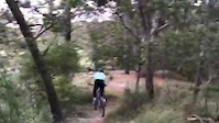
A sweet 50M trail starting by the field. It starts with a short steep chute into a chicken drop to weed out the wary into a 3-4 meter triple drop to a semi-flat landing. Bring your balls for this one and hope they don't weigh you down too much!

Local Trail Association
  • trail association logo
  • Please consider joining or donating to the local trail association to support
    trail development & maintenance.

Recent Activity on Trail

Past Week
  • 0 rides
  •  
6 Months
  • 0 rides
  •  
All
  • 4 rides
  • Last: Dec 1, 2022
update trails status or condition

Full Send Trail Reports

statusdatedescription
Oct 19, 2019 @ 9:46pm
Oct 19, 2019
reporter
Did some trail work and resurfaced it as it was a lil over grown now. Added a small step down that gives you a hella lot of speed into the send.
Jun 14, 2019 @ 12:32pm
Jun 14, 2019
reporter Super fast but still a bit sketch. The humps are slightly smoothing out. The full send is still an option.
more »
Status:
on Oct 19, 2019
Variable
Avg: 4.24 (2 votes)
Your vote: 0

view (62)
close
3D
Trail Conditions
  • Unknown
  • Snow Groomed
  • Snow Packed
  • Snow Covered
  • Snow Cover Partial
  • Freeze/thaw Cycle
  • Icy
  • Prevalent Mud
  • Wet
  • Variable
  • Ideal
  • Dry
  • Very Dry
Trail Flow (Ridden Direction)
Trailforks scans users ridelogs to determine the most popular direction each trail is ridden. A good flowing trail network will have most trails flowing in a single direction according to their intension.
The colour categories are based on what percentage of riders are riding a trail in its intended direction.
  • > 96%
  • > 90%
  • > 80%
  • > 70%
  • > 50%
  • < 50%
  • bi-directional trail
  • no data
Trail Last Ridden
Trailforks scans ridelogs to determine the last time a trail was ridden.
  • < 2 days
  • < 1 week
  • < 2 weeks
  • < 1 month
  • < 6 months
  • > 6 months
Trail Ridden Direction
The intended direction a trail should be ridden.
  • Downhill Only
  • Downhill Primary
  • Both Directions
  • Uphill Primary
  • Uphill Only
  • One Direction
Contribute Details
Colors indicate trail is missing specified detail.
  • Description
  • Photos
  • Description & Photos
  • Videos
Trail Popularity ?
Trailforks scans ridelogs to determine which trails are ridden the most in the last 9 months. Trails are compared with nearby trails in the same city region with a possible 25 colour shades. Think of this as a heatmap, more rides = more kinetic energy = warmer colors.
  • most popular
  • popular
  • less popular
  • not popular
ATV/ORV/OHV Filter
Max Vehicle Width
inches
US Cell Coverage
Legend
cell carrier legend

Radar Time
Activity Recordings
Trailforks uses anonymized public activity data. ?
Activity Recordings
Trailforks uses anonymized public activity data. ?
Personal Heatmap
Activity Types
all / none
Options
2
Date range month
Winter Trails
Warning A routing network for winter maps does not exist. Selecting trails using the winter trails layer has been disabled.
Missing Trails
Most Popular
Least Popular
Trails are colored based on popularity. The more popular a trail is, the more red. Less popular trails trend towards green.
Jump Magnitude Heatmap
Heatmap of where riders jump on trails. Zoom in to see individual jumps, click circles to view jump details.
BC Backroad Status

Service Road Atlas is a free to use, community-driven service for viewing and creating reports on the numerous back-country service roads around B.C. and Alberta.

map legend
Slope Aspect
Direction the slope faces
Flat N NE E SE S SW W NW
Trails Deemphasized
Trails are shown in grey.
disable
Only show trails with no bike usage.
Enable
Suggested Layers
Based on selected activity type

    Save the current map location and zoom level as your default home location whenever this page is loaded.

    Save
        Directions to full-send trailhead (-36.759020, 174.717790)

        Photos

        2 more »
        41 |
        Jan 3, 2025 @ 3:52pm
        Jan 3, 2025
        121 |
        Jul 20, 2021 @ 10:01pm
        Jul 20, 2021

        Videos

        2 more »
        Sketchy as
        0:06 | 359 | Jan 9, 2020 , Cambridge
        Full send
        0:15 | 374 | Apr 26, 2019 , Cambridge

        Reviews / Comments

        No reviews yet, be the first to write a review or ask a question.
        Use trail reports to comment on trail conditions.


        We hope you've been enjoying Trailforks!

        Create a FREE account to view trail comments and much more.

        • By Bmxmtbbro05 UBC & contributors
        • #182407 - 1,006 views

        Frequently Asked Questions About Full Send

        Where is Full Send located?
        Full Send is located in Unsworth Reserve, Cambridge, New Zealand. It is part of the Unsworth Reserve trail network. The trailhead is located at coordinates -36.75902, 174.71779.
        How hard is Full Send?
        Full Send is rated as Black Diamond difficulty. The physical rating is Moderate. The average grade is 8.8%. The climb difficulty is rated Green.
        What is the elevation gain for Full Send?
        The trail has 10 ft of elevation descent. The elevation ranges from 178 ft to 193 ft.
        Is Full Send a point to point trail?
        Yes, Full Send is a point to point trail. The direction is Downhill Only. The trail type is singletrack.

        Hit the Trail

        Open in App

        Get this trail on your phone instantly.
        open trail in app

        Download Trail

        Save to wishlist, Garmin & download.
        save the trail

        Find Related Routes

        Find routes and users activities that include this trail.
        find routes for this trail

        You must enter a description before submitting.