more stats
1.0 mile
Distance
16 ft
Climb
-957 ft
Descent
00:09:53
Avg time
-942 ft
Altitude change
1,073 ft
Altitude min
2,019 ft
Altitude max
2,018 ft
Altitude start
1,076 ft
Altitude end
-17.8%
Grade
-64.8%
Grade max
8.7%
Grade min
404 ft
Distance climb
4,839 ft
Distance down
56 ft
Distance flat
00:09:53
Avg time

Gamble Details

  • Activities
    • Mountain Bike
    • E-Bike
  • Riding Area
  • Difficulty Rating
  • Local Popularity
    55 in Mountain Biking [+]
    • 55 in E-Biking
  • Global Ranking
    #61087 in Mountain Biking [+]
    • #80170 in E-Biking
  • Trail Type
    Singletrack
  • Bike Type
    DH, AM
  • Direction
    Downhill Only
  • Dogs Allowed
    Yes
  • eBike Allowed
    Yes up to Class 1
  • TTFs on Trail
    Drop, Rock Garden
  • Land Owner

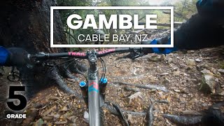
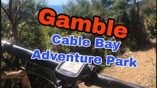
The all time classic of Cable Bay. Roll the dice and drop in into this beautiful rocky, rooty, technical singletrack which takes you from Blue Hill summit down to the Skywire. A long, full enduro run where it's always a bit of a gamble if you can make it all the way without putting a foot down. A pretty typical Nelson trail. Techy, narrow and heaps of spice. Absolute trailriding goodness.
There is a small, non rollable tree log drop after about 100m from the top.
Further down you will have a few different options to finish or continue your ride.

Recent Activity on Trail

Past Week
  • 0 rides
  •  
6 Months
  • 15 rides
  • 18 miles avg distance
All
  • 58 rides
  • Last: Apr 27, 2026
c1c2c3c4
January
February
March
April
May
June
July
August
September
October
November
December
update trails status or condition

Gamble Trail Reports

Status:
on Jan 7, 2026
Ideal
Avg: 4.49 (10 votes)
Your vote: 0

view (784)
close
3D
Trail Conditions
  • Unknown
  • Snow Groomed
  • Snow Packed
  • Snow Covered
  • Snow Cover Partial
  • Freeze/thaw Cycle
  • Icy
  • Prevalent Mud
  • Wet
  • Variable
  • Ideal
  • Dry
  • Very Dry
Trail Flow (Ridden Direction)
Trailforks scans users ridelogs to determine the most popular direction each trail is ridden. A good flowing trail network will have most trails flowing in a single direction according to their intension.
The colour categories are based on what percentage of riders are riding a trail in its intended direction.
  • > 96%
  • > 90%
  • > 80%
  • > 70%
  • > 50%
  • < 50%
  • bi-directional trail
  • no data
Trail Last Ridden
Trailforks scans ridelogs to determine the last time a trail was ridden.
  • < 2 days
  • < 1 week
  • < 2 weeks
  • < 1 month
  • < 6 months
  • > 6 months
Trail Ridden Direction
The intended direction a trail should be ridden.
  • Downhill Only
  • Downhill Primary
  • Both Directions
  • Uphill Primary
  • Uphill Only
  • One Direction
Contribute Details
Colors indicate trail is missing specified detail.
  • Description
  • Photos
  • Description & Photos
  • Videos
Trail Popularity ?
Trailforks scans ridelogs to determine which trails are ridden the most in the last 9 months. Trails are compared with nearby trails in the same city region with a possible 25 colour shades. Think of this as a heatmap, more rides = more kinetic energy = warmer colors.
  • most popular
  • popular
  • less popular
  • not popular
ATV/ORV/OHV Filter
Max Vehicle Width
inches
US Cell Coverage
Legend
cell carrier legend

Radar Time
Activity Recordings
Trailforks uses anonymized public activity data. ?
Activity Recordings
Trailforks uses anonymized public activity data. ?
Personal Heatmap
Activity Types
all / none
Options
2
Date range month
Winter Trails
Warning A routing network for winter maps does not exist. Selecting trails using the winter trails layer has been disabled.
Missing Trails
Most Popular
Least Popular
Trails are colored based on popularity. The more popular a trail is, the more red. Less popular trails trend towards green.
Jump Magnitude Heatmap
Heatmap of where riders jump on trails. Zoom in to see individual jumps, click circles to view jump details.
BC Backroad Status

Service Road Atlas is a free to use, community-driven service for viewing and creating reports on the numerous back-country service roads around B.C. and Alberta.

map legend
Slope Aspect
Direction the slope faces
Flat N NE E SE S SW W NW
Trails Deemphasized
Trails are shown in grey.
disable
Only show trails with no bike usage.
Enable
Suggested Layers
Based on selected activity type

    Save the current map location and zoom level as your default home location whenever this page is loaded.

    Save
        Directions to gamble trailhead (-41.203040, 173.446760)

        Photos

        11 more »
        129 |
        May 25, 2024 @ 1:44am
        May 25, 2024
        86 |
        Jun 1, 2023 @ 5:12pm
        Jun 1, 2023
        306 |
        Dec 8, 2021 @ 9:00pm
        Dec 8, 2021
        330 |
        Dec 8, 2021 @ 9:00pm
        Dec 8, 2021

        Videos

        5 more »
        youtuber LOOSE ROCKS & STEEP CHUTES - Gamble...
        6:54 | 613 | Dec 21, 2021 , Nelson
        Newest downhill trail at Cable Bay -...
        13:29 | 83 | Mar 22, 2025 , Nelson
        Gamble MTB Trail at Cable Bay Adventure Park
        3:36 | 541 | Mar 27, 2022 , Nelson
        youtuber Cablebay Adventure Park mountain bike track -...
        11:36 | 642 | Mar 14, 2019 , Nelson

        Routes with this trail

        16 miles 5,453 ft 28 Race
        The Cable Bay Enduro 2020

        2 Reviews & Comments


        We hope you've been enjoying Trailforks!

        Create a FREE account to view trail comments and much more.

        • By Cable-Bay-Adventure-ParkTF Pro CBAP & contributors
        • #256041 - 2,449 views

        Frequently Asked Questions About Gamble

        Where is Gamble located?
        Gamble is located in Cable Bay Adventure Park, Nelson, New Zealand. It is part of the Cable Bay Adventure Park trail network. The trailhead is located at coordinates -41.20304, 173.44676.
        How hard is Gamble?
        Gamble is rated as Black Diamond difficulty. The average grade is 17.8%.
        What is the elevation gain for Gamble?
        Gamble has 5 m of elevation gain. The trail has 292 m of elevation descent. The elevation ranges from 327 m to 616 m.
        Is Gamble a point to point trail?
        Yes, Gamble is a point to point trail. The direction is Downhill Only. The trail type is singletrack.

        Hit the Trail

        Open in App

        Get this trail on your phone instantly.
        open trail in app

        Download Trail

        Save to wishlist, Garmin & download.
        save the trail

        Find Related Routes

        Find routes and users activities that include this trail.
        find routes for this trail

        You must enter a description before submitting.