more stats
4,560 ft
Distance
-567 ft
Descent
00:07:31
Avg time
-565 ft
Altitude change
3,903 ft
Altitude min
4,471 ft
Altitude max
4,471 ft
Altitude start
3,907 ft
Altitude end
-12.4%
Grade
-45.3%
Grade max
2%
Grade min
102 ft
Distance climb
4,304 ft
Distance down
118 ft
Distance flat
00:07:31
Avg time

Gasifier Details

  • Activities
    • Mountain Bike
  • Riding Area
    Bighorn Ridge
    Hinton, Alberta
  • Difficulty Rating
  • Local Popularity
    65 in Mountain Biking
  • Global Ranking
    #89639 in Mountain Biking
  • Trail Type
    Singletrack
  • Bike Type
    DH, AM
  • Direction
    Downhill Primary
    Popular Direction Shown
  • Physical Rating
    Hard
  • Dogs Allowed
    Yes
  • eBike Allowed
  • Land Owner
    FRMA West Fraser

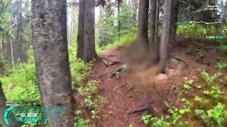
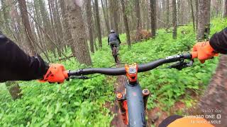
A classic fall line downhill trail, nothing fancy here, leave your berms and jumps at home. Just get yourself to the bottom in one piece without gassing. Harder than it sounds, this trail was the venue for the annual AFD Gravity Cup downhill race where local rippers challenge pro and amateur racers from afar.

Access Info

To get here head South on Robb Road (a few kms past the Bike Park) and look for the pullout on the right (stream crossing interpretation area). Drop a vehicle there and continue to McPherson road, hang left and follow it until the rough access road on the second left. Follow the access road to a dead end (well site) and look for the trailhead on the NW corner of the block.

Local Trail Association

Recent Activity on Trail

Past Week
  • 0 rides
  •  
6 Months
  • 1 rides
  • 4,967 ft avg distance
All
  • 14 rides
  • Last: May 18, 2026
c1c2c3c4
January
February
March
April
May
June
July
August
September
October
November
December
update trails status or condition

Gasifier Trail Reports

statusdatedescription
May 2, 2025 @ 8:12pm
May 2, 2025
A few tress down, some bigger ones (power saw) up top. Shuttle road still has snow/mud.
May 28, 2024 @ 4:26pm
May 28, 2024
rode it the 26th and the bridge was redone but theres a decent amount of fallen trees
Jul 20, 2023 @ 10:20pm
Jul 20, 2023
trail is good and majority was recently brushed. Bridges at bottom are damaged but can be crossed. It's a wide span so it will take some work to...
Jul 2, 2023 @ 6:10pm
Jul 2, 2023
Jul 2, 2023 @ 6:10pm
Jul 2, 2023
Little wet, little overgrown in some spots, bridge slowly falling apart. 3 downed trees.
more »
Status:
on May 2, 2025
Ideal
Avg: 4.43 (10 votes)
Your vote: 0

view (153)
close
3D
Trail Conditions
  • Unknown
  • Snow Groomed
  • Snow Packed
  • Snow Covered
  • Snow Cover Partial
  • Freeze/thaw Cycle
  • Icy
  • Prevalent Mud
  • Wet
  • Variable
  • Ideal
  • Dry
  • Very Dry
Trail Flow (Ridden Direction)
Trailforks scans users ridelogs to determine the most popular direction each trail is ridden. A good flowing trail network will have most trails flowing in a single direction according to their intension.
The colour categories are based on what percentage of riders are riding a trail in its intended direction.
  • > 96%
  • > 90%
  • > 80%
  • > 70%
  • > 50%
  • < 50%
  • bi-directional trail
  • no data
Trail Last Ridden
Trailforks scans ridelogs to determine the last time a trail was ridden.
  • < 2 days
  • < 1 week
  • < 2 weeks
  • < 1 month
  • < 6 months
  • > 6 months
Trail Ridden Direction
The intended direction a trail should be ridden.
  • Downhill Only
  • Downhill Primary
  • Both Directions
  • Uphill Primary
  • Uphill Only
  • One Direction
Contribute Details
Colors indicate trail is missing specified detail.
  • Description
  • Photos
  • Description & Photos
  • Videos
Trail Popularity ?
Trailforks scans ridelogs to determine which trails are ridden the most in the last 9 months. Trails are compared with nearby trails in the same city region with a possible 25 colour shades. Think of this as a heatmap, more rides = more kinetic energy = warmer colors.
  • most popular
  • popular
  • less popular
  • not popular
ATV/ORV/OHV Filter
Max Vehicle Width
inches
US Cell Coverage
Legend
cell carrier legend

Radar Time
Activity Recordings
Trailforks uses anonymized public activity data. ?
Activity Recordings
Trailforks uses anonymized public activity data. ?
Personal Heatmap
Activity Types
all / none
Options
2
Date range month
Winter Trails
Warning A routing network for winter maps does not exist. Selecting trails using the winter trails layer has been disabled.
Missing Trails
Most Popular
Least Popular
Trails are colored based on popularity. The more popular a trail is, the more red. Less popular trails trend towards green.
Jump Magnitude Heatmap
Heatmap of where riders jump on trails. Zoom in to see individual jumps, click circles to view jump details.
BC Backroad Status

Service Road Atlas is a free to use, community-driven service for viewing and creating reports on the numerous back-country service roads around B.C. and Alberta.

map legend
Slope Aspect
Direction the slope faces
Flat N NE E SE S SW W NW
Trails Deemphasized
Trails are shown in grey.
disable
Only show trails with no bike usage.
Enable
Suggested Layers
Based on selected activity type

    Save the current map location and zoom level as your default home location whenever this page is loaded.

    Save
        Directions to gasifier trailhead (53.364900, -117.537180)

        Photos

        12 more »
        27 |
        Feb 8, 2026 @ 10:35am
        Feb 8, 2026
        27 |
        Feb 8, 2026 @ 10:35am
        Feb 8, 2026
        99 |
        May 26, 2019 @ 4:35pm
        May 26, 2019
        90 |
        May 26, 2019 @ 4:34pm
        May 26, 2019

        Videos

        4 more »
        Gassifier ◇ at Hinton
        7:54 | 185 | Sep 22, 2022 , Hinton
        Gasifier
        3:50 | 136 | Aug 1, 2022 , Hinton
        Hinton Bike Park - Gasifier
        15:31 | 338 | Feb 17, 2021 , Hinton
        Gasifier DH Hinton
        1255 | Sep 12, 2017 , Hinton

        Routes with this trail

        41 miles 5,148 ft 20 Loop
        This covers all of the xc trails in the Hinton Bike Park.

        4 Reviews & Comments


        We hope you've been enjoying Trailforks!

        Create a FREE account to view trail comments and much more.

        • By napsack & contributors
        • #16487 - 3,030 views

        Frequently Asked Questions About Gasifier

        Where is Gasifier located?
        Gasifier is located in Bighorn Ridge, Hinton, Alberta, Canada. It is part of the Bighorn Ridge trail network. The trailhead is located at coordinates 53.3649, -117.53718.
        How hard is Gasifier?
        Gasifier is rated as Black Diamond difficulty. The physical rating is Hard. The average grade is 12.4%.
        What is the elevation gain for Gasifier?
        The trail has 567 ft of elevation descent. The elevation ranges from 3,903 ft to 4,471 ft.
        Is Gasifier a point to point trail?
        Gasifier is not a point to point trail. The direction is Downhill Primary. The trail type is singletrack.

        Hit the Trail

        Open in App

        Get this trail on your phone instantly.
        open trail in app

        Download Trail

        Save to wishlist, Garmin & download.
        save the trail

        Find Related Routes

        Find routes and users activities that include this trail.
        find routes for this trail

        You must enter a description before submitting.