more stats
1.3 miles
Distance
92 ft
Climb
-706 ft
Descent
01:47:01
Avg time
-614 ft
Altitude change
109 ft
Altitude min
723 ft
Altitude max
723 ft
Altitude start
109 ft
Altitude end
-9.048%
Grade
-38.26%
Grade max
31.826%
Grade min
1,746 ft
Distance climb
4,645 ft
Distance down
397 ft
Distance flat
01:47:01
Avg time

Gasp Details

  • Activities
    • Mountain Bike
    • Hike
    • Trail Running
  • Riding Area
    Laie Falls
    Laie, Hawaii
  • Difficulty Rating
  • Local Popularity
    5 in Mountain Biking [+]
    • 5 in Trail Running
    • 5 in Hiking
  • Global Ranking
    #64585 in Mountain Biking [+]
    • #69227 in Hiking
  • Trail Type
    Singletrack
  • Bike Type
    AM, XC
  • Direction
    Both Directions
    Popular In Reverse
  • Climb Difficulty
    Double Black Diamond
  • Physical Rating
    Extreme
  • Dogs Allowed
    Yes

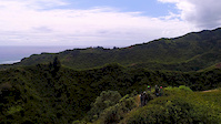
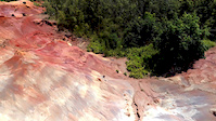
Like most of Laie trails, this climb is steep and natural. With practice it can mostly be ridden and will make you tough as nails trying. It's the best way to get to the top of this ridge. Totally worth it, beautiful view from the top and several awesome technical descents. Because of all the pine needles this trail actually hold up well in wet conditions compared to other trails in the area.

Traditionally Indigenous Territory

Recent Activity on Trail

Past Week
  • 0 rides
  •  
6 Months
  • 0 rides
  •  
All
  • 3 rides
  • Last: Feb 6, 2023
c1c2c3c4
January
February
March
April
May
June
July
August
September
October
November
December
update trails status or condition

Gasp Trail Reports

statusdatedescription
Jan 2, 2023 @ 1:48pm
Jan 2, 2023
reporter Pretty clear right now. The upper part once you hit the ridge is a bit overgrown but still fun. A few tall grassy spots but that's pretty much...
Sep 18, 2021 @ 6:22pm
Sep 18, 2021
Some branches encroaching, but is still very much rideable. Awesome views up top.
Apr 6, 2019 @ 1:08pm
Apr 6, 2019
reporter
Mar 7, 2019 @ 10:56am
Mar 7, 2019
reporter Bit overgrown but it's dry and still loads of fun.
Feb 16, 2019 @ 12:21am
Feb 16, 2019
One small tree down over trail on ground, can ride over.
more »
Status:
on Jan 2, 2023
Ideal
Avg: 3.98 (1 votes)
Your vote: 0

view (12)
close
3D
Trail Conditions
  • Unknown
  • Snow Groomed
  • Snow Packed
  • Snow Covered
  • Snow Cover Partial
  • Freeze/thaw Cycle
  • Icy
  • Prevalent Mud
  • Wet
  • Variable
  • Ideal
  • Dry
  • Very Dry
Trail Flow (Ridden Direction)
Trailforks scans users ridelogs to determine the most popular direction each trail is ridden. A good flowing trail network will have most trails flowing in a single direction according to their intension.
The colour categories are based on what percentage of riders are riding a trail in its intended direction.
  • > 96%
  • > 90%
  • > 80%
  • > 70%
  • > 50%
  • < 50%
  • bi-directional trail
  • no data
Trail Last Ridden
Trailforks scans ridelogs to determine the last time a trail was ridden.
  • < 2 days
  • < 1 week
  • < 2 weeks
  • < 1 month
  • < 6 months
  • > 6 months
Trail Ridden Direction
The intended direction a trail should be ridden.
  • Downhill Only
  • Downhill Primary
  • Both Directions
  • Uphill Primary
  • Uphill Only
  • One Direction
Contribute Details
Colors indicate trail is missing specified detail.
  • Description
  • Photos
  • Description & Photos
  • Videos
Trail Popularity ?
Trailforks scans ridelogs to determine which trails are ridden the most in the last 9 months. Trails are compared with nearby trails in the same city region with a possible 25 colour shades. Think of this as a heatmap, more rides = more kinetic energy = warmer colors.
  • most popular
  • popular
  • less popular
  • not popular
ATV/ORV/OHV Filter
Max Vehicle Width
inches
US Cell Coverage
Legend
cell carrier legend

Radar Time
Activity Recordings
Trailforks uses anonymized public activity data. ?
Activity Recordings
Trailforks uses anonymized public activity data. ?
Personal Heatmap
Activity Types
all / none
Options
2
Date range month
Winter Trails
Warning A routing network for winter maps does not exist. Selecting trails using the winter trails layer has been disabled.
Missing Trails
Most Popular
Least Popular
Trails are colored based on popularity. The more popular a trail is, the more red. Less popular trails trend towards green.
Jump Magnitude Heatmap
Heatmap of where riders jump on trails. Zoom in to see individual jumps, click circles to view jump details.
BC Backroad Status

Service Road Atlas is a free to use, community-driven service for viewing and creating reports on the numerous back-country service roads around B.C. and Alberta.

map legend
Slope Aspect
Direction the slope faces
Flat N NE E SE S SW W NW
Trails Deemphasized
Trails are shown in grey.
disable
Only show trails with no bike usage.
Enable
Suggested Layers
Based on selected activity type

    Save the current map location and zoom level as your default home location whenever this page is loaded.

    Save
        Directions to gasp trailhead (21.623510, -157.939640)

        Photos

        19 more »
        512 |
        Feb 21, 2017 @ 1:05am
        Feb 21, 2017
        413 |
        Feb 21, 2017 @ 1:05am
        Feb 21, 2017
        97 |
        Sep 18, 2021 @ 5:51pm
        Sep 18, 2021
        92 |
        Sep 18, 2021 @ 5:51pm
        Sep 18, 2021

        Videos

        2 more »
        Hawaii Ridgelines - Drone
        0:09 | 453 | May 22, 2017 , Laie
        Hawaii Hidden Treasures
        0:41 | 497 | May 22, 2017 , Laie

        1 Review & Comments


        We hope you've been enjoying Trailforks!

        Create a FREE account to view trail comments and much more.

        Nearby Trails

        • By mikeysolisTF Pro & contributors
        • #6569 - 3,252 views

        Frequently Asked Questions About Gasp

        Where is Gasp located?
        Gasp is located in Laie Falls, Laie, Hawaii, United States. It is part of the Laie Falls trail network. The trailhead is located at coordinates 21.62351, -157.93964.
        How hard is Gasp?
        Gasp is rated as Black Diamond difficulty. The physical rating is Extreme. The average grade is 9.048%. The climb difficulty is rated Double Black Diamond.
        What is the elevation gain for Gasp?
        Gasp has 92 ft of elevation gain. The trail has 706 ft of elevation descent. The elevation ranges from 109 ft to 723 ft.
        Is Gasp a point to point trail?
        Gasp is not a point to point trail. The direction is Both Directions. The trail type is singletrack.

        Hit the Trail

        Open in App

        Get this trail on your phone instantly.
        open trail in app

        Download Trail

        Save to wishlist, Garmin & download.
        save the trail

        Find Related Routes

        Find routes and users activities that include this trail.
        find routes for this trail

        You must enter a description before submitting.