more stats
1.1 miles
Distance
-1,527 ft
Descent
00:22:17
Avg time
-1,527 ft
Altitude change
3,177 ft
Altitude min
4,704 ft
Altitude max
4,704 ft
Altitude start
3,176 ft
Altitude end
-25.9%
Grade
-113.4%
Grade max
-5.2%
Grade min
16 ft
Distance climb
1 mile
Distance down
00:22:17
Avg time

Getscho Details

  • Activities
    • Mountain Bike
    • E-Bike
  • Riding Area
  • Difficulty Rating
  • Voted Difficulty
    Double Black Diamond (5 votes)
  • Local Popularity
    20 in Mountain Biking [+]
    • 10 in E-Biking
  • Global Ranking
    #107870 in Mountain Biking [+]
    • #103238 in E-Biking
  • Trail Type
    Singletrack
  • Bike Type
    DH, AM
  • Direction
    Downhill Only
    Popular Direction Shown
  • Physical Rating
    Hard
  • Trail Visibility
    Always easy to follow
  • Season
    Jan - Dec
  • Alpine Trail
    Yes
  • Dogs Allowed
    Yes
  • eBike Allowed
    Yes up to Class 1
  • TTFs on Trail
    Berm, Jump, Gap Jump, Rock Face, Skinny, Other
  • Ride in Rain
    Yes
  • Year Opened
    2014
  • Land Owner

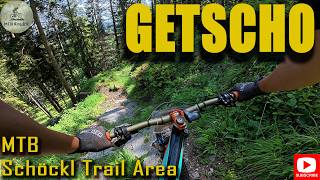
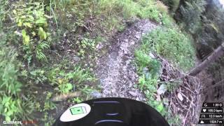
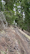
Steep, lots of rocks and roots. All in all a very natural trail. Tight switchbacks alter with highspeed parts. Some sections are from downhill European championships in 2003.

Access Info

From the exit at the top station of the gondola follow the black signs to the left.

Disclaimer

Wearing a helmet is compulsory. Ride at your own risk.

Bike Park

Recent Activity on Trail

Past Week
  • 0 rides
  •  
6 Months
  • 2 rides
  • 17 miles avg distance
All
  • 15 rides
  • Last: May 16, 2026
c1c2c3c4
January
February
March
April
May
June
July
August
September
October
November
December
update trails status or condition

Getscho Trail Reports

statusdatedescription
Oct 3, 2025 @ 12:37pm (Europe/Vienna)
Oct 3, 2025
Full gnar, but good conditions for it!
Apr 14, 2021 @ 11:04pm
Apr 14, 2021
Chairway and all trails are open again for summer-season. Please inform yourself about current COVID-19 rules and detailed opening/operation hours..
Feb 22, 2021 @ 11:00am
Feb 22, 2021
reporter Bikepark closed due to revision-works at the gondola. Bikepark opens again at 14. March 2021
Dec 24, 2020 @ 11:00am
Dec 24, 2020
reporter Chairway and all trails are open again. Please respect COVID-19 rules (you need FFP2-masks)
Nov 27, 2020 @ 1:00pm
Nov 27, 2020
more »
Status:
on Oct 3, 2025
Ideal
Avg: 4.49 (8 votes)
Your vote: 0

view (139)
close
3D
Trail Conditions
  • Unknown
  • Snow Groomed
  • Snow Packed
  • Snow Covered
  • Snow Cover Partial
  • Freeze/thaw Cycle
  • Icy
  • Prevalent Mud
  • Wet
  • Variable
  • Ideal
  • Dry
  • Very Dry
Trail Flow (Ridden Direction)
Trailforks scans users ridelogs to determine the most popular direction each trail is ridden. A good flowing trail network will have most trails flowing in a single direction according to their intension.
The colour categories are based on what percentage of riders are riding a trail in its intended direction.
  • > 96%
  • > 90%
  • > 80%
  • > 70%
  • > 50%
  • < 50%
  • bi-directional trail
  • no data
Trail Last Ridden
Trailforks scans ridelogs to determine the last time a trail was ridden.
  • < 2 days
  • < 1 week
  • < 2 weeks
  • < 1 month
  • < 6 months
  • > 6 months
Trail Ridden Direction
The intended direction a trail should be ridden.
  • Downhill Only
  • Downhill Primary
  • Both Directions
  • Uphill Primary
  • Uphill Only
  • One Direction
Contribute Details
Colors indicate trail is missing specified detail.
  • Description
  • Photos
  • Description & Photos
  • Videos
Trail Popularity ?
Trailforks scans ridelogs to determine which trails are ridden the most in the last 9 months. Trails are compared with nearby trails in the same city region with a possible 25 colour shades. Think of this as a heatmap, more rides = more kinetic energy = warmer colors.
  • most popular
  • popular
  • less popular
  • not popular
ATV/ORV/OHV Filter
Max Vehicle Width
inches
US Cell Coverage
Legend
cell carrier legend

Radar Time
Activity Recordings
Trailforks uses anonymized public activity data. ?
Activity Recordings
Trailforks uses anonymized public activity data. ?
Personal Heatmap
Activity Types
all / none
Options
2
Date range month
Winter Trails
Warning A routing network for winter maps does not exist. Selecting trails using the winter trails layer has been disabled.
Missing Trails
Most Popular
Least Popular
Trails are colored based on popularity. The more popular a trail is, the more red. Less popular trails trend towards green.
Jump Magnitude Heatmap
Heatmap of where riders jump on trails. Zoom in to see individual jumps, click circles to view jump details.
BC Backroad Status

Service Road Atlas is a free to use, community-driven service for viewing and creating reports on the numerous back-country service roads around B.C. and Alberta.

map legend
Slope Aspect
Direction the slope faces
Flat N NE E SE S SW W NW
Trails Deemphasized
Trails are shown in grey.
disable
Only show trails with no bike usage.
Enable
Suggested Layers
Based on selected activity type

    Save the current map location and zoom level as your default home location whenever this page is loaded.

    Save
        Directions to getscho trailhead (47.198658, 15.467967)

        Photos

        3 more »
        261 |
        Nov 20, 2019 @ 6:10am
        Nov 20, 2019
        838 |
        Sep 25, 2017 @ 8:00am
        Sep 25, 2017
        721 |
        May 29, 2015 @ 4:46am
        May 29, 2015

        Videos

        5 more »
        Extrémne náročný Double Black Diamond...
        9:54 | 47 | Jan 6, 2026 , Graz
        Downhill Schöckl | LINES
        1204 | Dec 10, 2015 , Graz
        Crash in Scöckl
        0:08 | 374 | Apr 13, 2021 , Graz
        Downhill Track
        0:42 | 952 | Apr 17, 2011 , Graz

        1 Review & Comments


        We hope you've been enjoying Trailforks!

        Create a FREE account to view trail comments and much more.

        • By linesTF Pro TRAILFORKS & contributors
        • #43780 - 3,063 views

        Frequently Asked Questions About Getscho

        Where is Getscho located?
        Getscho is located in Schöckl Trail Area, Graz, Austria. It is part of the Schöckl Trail Area trail network. The trailhead is located at coordinates 47.19866, 15.46797.
        How hard is Getscho?
        Getscho is rated as Black difficulty. The physical rating is Hard. The average grade is 25.9%.
        What is the elevation gain for Getscho?
        The trail has 1,527 ft of elevation descent. The elevation ranges from 3,177 ft to 4,704 ft.
        Is Getscho a point to point trail?
        Yes, Getscho is a point to point trail. The direction is Downhill Only. The trail type is singletrack.

        Hit the Trail

        Open in App

        Get this trail on your phone instantly.
        open trail in app

        Download Trail

        Save to wishlist, Garmin & download.
        save the trail

        Find Related Routes

        Find routes and users activities that include this trail.
        find routes for this trail

        You must enter a description before submitting.