more stats
1.4 miles
Distance
15 ft
Climb
-1,483 ft
Descent
00:17:01
Avg time
-1,468 ft
Altitude change
1,320 ft
Altitude min
2,788 ft
Altitude max
2,788 ft
Altitude start
1,319 ft
Altitude end
-19.4%
Grade
-89.3%
Grade max
12.4%
Grade min
367 ft
Distance climb
1 mile
Distance down
220 ft
Distance flat
00:17:01
Avg time

Ginjas Details

  • Activities
    • Mountain Bike
    • Hike
    • Trail Running
  • Riding Area
  • AKA
    Pista DH das Ginjas
  • Difficulty Rating
  • Voted Difficulty
    Double Black Diamond (2 votes)
  • Local Popularity
    90 in Mountain Biking [+]
    • 75 in Trail Running
    • 5 in Hiking
  • Global Ranking
    #44806 in Mountain Biking [+]
    • #82120 in Trail Running
    • #125885 in Hiking
  • Trail Type
    Mixed
  • Bike Type
    DH, AM
  • Direction
    Downhill Primary
    Popular Direction Shown
  • Climb Difficulty
    Black Diamond
  • Physical Rating
    Hard
  • Season
    All year
  • Dogs Allowed
    Yes
  • TTFs on Trail
    Drop, Jump, Gap Jump, Other

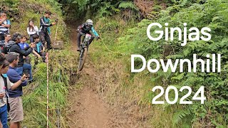
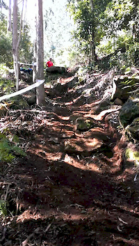
Pista muito inclinada, técnica, piso de terra e raízes, varios drop ao longo do trilho de nivel Hard. Pista de prova DH na Ilha da Madeira. Passeio divertido, é vir do trilho de crosscountry da Bica da Cana até os Estanquinhos, descer o estradão até ao inicio da pista. Ao chegar á estrada de alcatrão, mesmo de frente, tem uma pequena entrada para uma vereda em pedra e depois no fim, degraus, um pouco tecnica e divertida.

Access Info

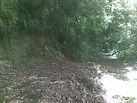
Acima do parque empresarial de São Vicente, subir o estradão de terra, ou então descer o estradão na zona dos Estanquinhos no Paul da Serra. trilho começa á esquerda de quem desce, após uma curva fechada á direita, se tiver a subir, é no lado direito antes da primeira curva fechada á esquerda.

This trail is unsanctioned.

Recent Activity on Trail

Past Week
  • 0 rides
  •  
6 Months
  • 7 rides
  • 27 miles avg distance
All
  • 47 rides
  • Last: Jun 16, 2026
c1c2c3c4
January
February
March
April
May
June
July
August
September
October
November
December
update trails status or condition

Ginjas Trail Reports

statusdatedescription
Oct 12, 2025 @ 6:16pm (Europe/Lisbon)
Oct 12, 2025
Fun! Definitely not black.
Aug 20, 2023 @ 7:29am
Aug 20, 2023
Minor erosion (trail braiding, small ruts developing, brake bumps)
Feb 12, 2023 @ 12:28am
Feb 12, 2023
Small tree down across trail, can ride over or around Antes da última levada, depois do salto de mesa houve uma derrocada
Sep 23, 2021 @ 1:34am
Sep 23, 2021
some corners slippery and wet. but fun to ride.
Dec 31, 2019 @ 10:30am
Dec 31, 2019
Minor Water drainage issue, standing water on trail surface Small tree down across trail, can ride over or around
more »
Status:
on Oct 12, 2025
Dry
Avg: 4.39 (5 votes)
Your vote: 0

view (318)
close
3D
Trail Conditions
  • Unknown
  • Snow Groomed
  • Snow Packed
  • Snow Covered
  • Snow Cover Partial
  • Freeze/thaw Cycle
  • Icy
  • Prevalent Mud
  • Wet
  • Variable
  • Ideal
  • Dry
  • Very Dry
Trail Flow (Ridden Direction)
Trailforks scans users ridelogs to determine the most popular direction each trail is ridden. A good flowing trail network will have most trails flowing in a single direction according to their intension.
The colour categories are based on what percentage of riders are riding a trail in its intended direction.
  • > 96%
  • > 90%
  • > 80%
  • > 70%
  • > 50%
  • < 50%
  • bi-directional trail
  • no data
Trail Last Ridden
Trailforks scans ridelogs to determine the last time a trail was ridden.
  • < 2 days
  • < 1 week
  • < 2 weeks
  • < 1 month
  • < 6 months
  • > 6 months
Trail Ridden Direction
The intended direction a trail should be ridden.
  • Downhill Only
  • Downhill Primary
  • Both Directions
  • Uphill Primary
  • Uphill Only
  • One Direction
Contribute Details
Colors indicate trail is missing specified detail.
  • Description
  • Photos
  • Description & Photos
  • Videos
Trail Popularity ?
Trailforks scans ridelogs to determine which trails are ridden the most in the last 9 months. Trails are compared with nearby trails in the same city region with a possible 25 colour shades. Think of this as a heatmap, more rides = more kinetic energy = warmer colors.
  • most popular
  • popular
  • less popular
  • not popular
ATV/ORV/OHV Filter
Max Vehicle Width
inches
US Cell Coverage
Legend
cell carrier legend

Radar Time
Activity Recordings
Trailforks uses anonymized public activity data. ?
Activity Recordings
Trailforks uses anonymized public activity data. ?
Personal Heatmap
Activity Types
all / none
Options
2
Date range month
Winter Trails
Warning A routing network for winter maps does not exist. Selecting trails using the winter trails layer has been disabled.
Missing Trails
Most Popular
Least Popular
Trails are colored based on popularity. The more popular a trail is, the more red. Less popular trails trend towards green.
Jump Magnitude Heatmap
Heatmap of where riders jump on trails. Zoom in to see individual jumps, click circles to view jump details.
BC Backroad Status

Service Road Atlas is a free to use, community-driven service for viewing and creating reports on the numerous back-country service roads around B.C. and Alberta.

map legend
Slope Aspect
Direction the slope faces
Flat N NE E SE S SW W NW
Trails Deemphasized
Trails are shown in grey.
disable
Only show trails with no bike usage.
Enable
Suggested Layers
Based on selected activity type

    Save the current map location and zoom level as your default home location whenever this page is loaded.

    Save
        Directions to ginjas trailhead (32.775790, -17.052530)

        Photos

        164 more »
        81 |
        Nov 9, 2025 @ 11:08am
        Nov 9, 2025
        88 |
        Mar 27, 2023 @ 4:09pm
        Mar 27, 2023
        42 |
        Mar 27, 2023 @ 4:09pm
        Mar 27, 2023
        58 |
        Mar 27, 2023 @ 4:10pm
        Mar 27, 2023

        Videos

        7 more »
        youtuber Campeonato Downhill 2024 || Madeira MTB
        4:18 | 236 | Jun 16, 2024 , Madeira
        youtuber 2º TAÇA DOWNHILL DA MADEIRA 2023 - GINJAS
        7:34 | 328 | May 5, 2023 , Madeira
        ginjas são vicente
        0:08 | 210 | May 24, 2016 , Madeira
        salto de mesa ...ginjas...
        0:17 | 230 | Sep 1, 2011 , Madeira

        Routes with this trail

        11 miles 2,496 ft 4
        Rota de algum esforço físico e perto de 4 horas para a fazer, fazemos bem com uma bíke DH também, tem...

        Reviews / Comments

        No reviews yet, be the first to write a review or ask a question.
        Use trail reports to comment on trail conditions.


        We hope you've been enjoying Trailforks!

        Create a FREE account to view trail comments and much more.

        • #25090 - 3,554 views

        Frequently Asked Questions About Ginjas

        Where is Ginjas located?
        Ginjas is located in Madeira, Portugal. It is part of the Madeira trail network. The trailhead is located at coordinates 32.77579, -17.05253.
        How hard is Ginjas?
        Ginjas is rated as Black difficulty. The physical rating is Hard. The average grade is 19.4%. The climb difficulty is rated Black Diamond.
        What is the elevation gain for Ginjas?
        Ginjas has 5 m of elevation gain. The trail has 452 m of elevation descent. The elevation ranges from 402 m to 850 m.
        Is Ginjas a point to point trail?
        Ginjas is not a point to point trail. The direction is Downhill Primary. The trail type is mixed.

        Hit the Trail

        Open in App

        Get this trail on your phone instantly.
        open trail in app

        Download Trail

        Save to wishlist, Garmin & download.
        save the trail

        Find Related Routes

        Find routes and users activities that include this trail.
        find routes for this trail

        You must enter a description before submitting.