more stats
1.9 miles
Distance
194 ft
Climb
-196 ft
Descent
00:14:53
Avg time
-2 ft
Altitude change
7,359 ft
Altitude min
7,517 ft
Altitude max
7,361 ft
Altitude start
7,359 ft
Altitude end
-18.3%
Grade max
22.1%
Grade min
4,495 ft
Distance climb
5,102 ft
Distance down
633 ft
Distance flat
00:14:53
Avg time

Gladiator Loop Details

  • Activities
    • Mountain Bike
    • Gravel Bike
    • Adaptive Bike
    • Winter Fat Bike
    • Hike
    • Trail Running
  • Riding Area
    Galena Lodge
    Ketchum, Idaho
  • Difficulty Rating
  • Voted Difficulty
    Blue (1 vote)
  • Local Popularity
    85 in Mountain Biking [+]
    • 5 in Trail Running
    • 70 in Hiking
  • Global Ranking
    #63642 in Mountain Biking [+]
    • #97183 in Trail Running
    • #55670 in Hiking
  • Hiking SAC Scale
    T2 Mountain Hiking
  • Trail Type
    Singletrack
  • Bike Type
    AM, XC, Fat, Adaptive MTB, CX, Gravel
  • Direction
    Both Directions[+]
    • Both Directions for Gravel Biking
  • Climb Difficulty
    Blue
  • Physical Rating
    Moderate
  • Trail Visibility
    Always easy to follow
  • Season
    June-Oct
  • Family Friendly
    Yes
  • Dogs Allowed
    Yes
  • eBike Allowed
  • TTFs on Trail
    Berm, Jump
  • Land Owner
    USFS

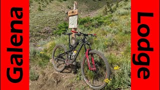
Gladiator Loop is an intermediate trail 3 miles long. It pairs well with Rip and Tear, Outhouse and Lodge Loop.

Like all of the singletrack trails at Galena, the Gladiator Loop Trail is open to two-way traffic and shared use by hikers, horseback riders, runners, and bicyclists. Watch for and yield to others - on this and all trails. All Galena singletrack trails are closed to E-Bikes.

Disclaimer

The USFS has implemented the Big Wood Travel Plan which includes decommissioning many old mining roads in the area.

Adaptive Bike Info
aMTB Green Rating: Beginner features and moderate terrain.
Trail Supporters

  • USFS
    Land Manager
Local Trail Association
Traditionally Indigenous Territory

Recent Activity on Trail

Past Week
  • 1 rides
  • 31 miles average
6 Months
  • 1 rides
  • 31 miles avg distance
All
  • 172 rides
  • Last: Jun 6, 2026
c1c2c3c4
January
February
March
April
May
June
July
August
September
October
November
December
update trails status or condition

Gladiator Loop Trail Reports

statusdatedescription
Jun 2, 2026 @ 11:35am (America/Boise)
Jun 2, 2026
Clear according to BCRD. Its really too bad that they aren't crossposting as conditions change.
Oct 30, 2025 @ 2:15pm (America/Boise)
Oct 30, 2025
Snow covered and will not melt out until spring.
Jun 30, 2025 @ 7:01pm
Jun 30, 2025
Nov 18, 2024 @ 3:17pm
Nov 18, 2024
Snow covered and will not melt out until spring.
Jun 17, 2024 @ 12:07pm
Jun 17, 2024
Good to ride! Trees cleared and snow free as of 6/17
more »
Status:
on Jun 2, 2026
Ideal
Avg: 3.99 (5 votes)
Your vote: 0

view (738)
close
3D
Trail Conditions
  • Unknown
  • Snow Groomed
  • Snow Packed
  • Snow Covered
  • Snow Cover Partial
  • Freeze/thaw Cycle
  • Icy
  • Prevalent Mud
  • Wet
  • Variable
  • Ideal
  • Dry
  • Very Dry
Trail Flow (Ridden Direction)
Trailforks scans users ridelogs to determine the most popular direction each trail is ridden. A good flowing trail network will have most trails flowing in a single direction according to their intension.
The colour categories are based on what percentage of riders are riding a trail in its intended direction.
  • > 96%
  • > 90%
  • > 80%
  • > 70%
  • > 50%
  • < 50%
  • bi-directional trail
  • no data
Trail Last Ridden
Trailforks scans ridelogs to determine the last time a trail was ridden.
  • < 2 days
  • < 1 week
  • < 2 weeks
  • < 1 month
  • < 6 months
  • > 6 months
Trail Ridden Direction
The intended direction a trail should be ridden.
  • Downhill Only
  • Downhill Primary
  • Both Directions
  • Uphill Primary
  • Uphill Only
  • One Direction
Contribute Details
Colors indicate trail is missing specified detail.
  • Description
  • Photos
  • Description & Photos
  • Videos
Trail Popularity ?
Trailforks scans ridelogs to determine which trails are ridden the most in the last 9 months. Trails are compared with nearby trails in the same city region with a possible 25 colour shades. Think of this as a heatmap, more rides = more kinetic energy = warmer colors.
  • most popular
  • popular
  • less popular
  • not popular
ATV/ORV/OHV Filter
Max Vehicle Width
inches
US Cell Coverage
Legend
cell carrier legend

Radar Time
Activity Recordings
Trailforks uses anonymized public activity data. ?
Activity Recordings
Trailforks uses anonymized public activity data. ?
Personal Heatmap
Activity Types
all / none
Options
2
Date range month
Winter Trails
Warning A routing network for winter maps does not exist. Selecting trails using the winter trails layer has been disabled.
Missing Trails
Most Popular
Least Popular
Trails are colored based on popularity. The more popular a trail is, the more red. Less popular trails trend towards green.
Jump Magnitude Heatmap
Heatmap of where riders jump on trails. Zoom in to see individual jumps, click circles to view jump details.
BC Backroad Status

Service Road Atlas is a free to use, community-driven service for viewing and creating reports on the numerous back-country service roads around B.C. and Alberta.

map legend
Slope Aspect
Direction the slope faces
Flat N NE E SE S SW W NW
Trails Deemphasized
Trails are shown in grey.
disable
Only show trails with no bike usage.
Enable
Suggested Layers
Based on selected activity type

    Save the current map location and zoom level as your default home location whenever this page is loaded.

    Save
        Directions to gladiator-loop trailhead (43.876840, -114.654960)

        Photos

        4 more »
        104 |
        Jan 23, 2020 @ 5:45pm
        Jan 23, 2020
        102 |
        Jan 23, 2020 @ 5:45pm
        Jan 23, 2020
        74 |
        Aug 3, 2019 @ 3:56pm
        Aug 3, 2019
        60 |
        Aug 3, 2019 @ 3:53pm
        Aug 3, 2019

        Videos

        1 more »
        If Heaven Has Flow Trails! Mountain Biking...
        30:44 | 227 | Aug 9, 2020 , Ketchum

        2 Reviews & Comments


        We hope you've been enjoying Trailforks!

        Create a FREE account to view trail comments and much more.

        • By jandashetlerTF Pro & contributors
        • #54209 - 1,536 views

        Frequently Asked Questions About Gladiator Loop

        Where is Gladiator Loop located?
        Gladiator Loop is located in Galena Lodge, Ketchum, Idaho, United States. It is part of the Galena Lodge trail network. The trailhead is located at coordinates 43.87684, -114.65496.
        How hard is Gladiator Loop?
        Gladiator Loop is rated as Blue difficulty. The physical rating is Moderate. The climb difficulty is rated Blue.
        What is the elevation gain for Gladiator Loop?
        Gladiator Loop has 194 ft of elevation gain. The trail has 196 ft of elevation descent. The elevation ranges from 7,359 ft to 7,517 ft.
        Is Gladiator Loop a point to point trail?
        Gladiator Loop is not a point to point trail. The direction is Both Directions. The trail type is singletrack.

        Hit the Trail

        Open in App

        Get this trail on your phone instantly.
        open trail in app

        Download Trail

        Save to wishlist, Garmin & download.
        save the trail

        Find Related Routes

        Find routes and users activities that include this trail.
        find routes for this trail

        You must enter a description before submitting.