
more stats
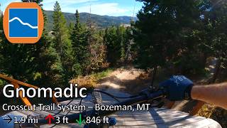
1.9 miles
Distance
3 ft
Climb
-846 ft
Descent
00:13:52
Avg time
-844 ft
Altitude change
6,082 ft
Altitude min
6,926 ft
Altitude max
6,926 ft
Altitude start
6,083 ft
Altitude end
-8.3%
Grade
-37.6%
Grade max
3.5%
Grade min
194 ft
Distance climb
2 miles
Distance down
797 ft
Distance flat
00:13:52
Avg time

Gnomadic Details

  • Activities
    • Mountain Bike
    • E-Bike
  • Riding Area
    Crosscut Trail System
    Bozeman, Montana
  • Difficulty Rating
  • Voted Difficulty
    Blue (3 votes)
  • Local Popularity
    100 in Mountain Biking heatmap [+]
    • 100 in E-Biking
  • Global Ranking
    #118 in Mountain Biking [+]
    • #2553 in E-Biking
  • State Ranking
    #1 in Mountain Biking · Montana [+]
    • #2 in E-Biking
  • Trail Type
    Machine Groomed
  • Bike Type
    DH, DJ
  • Physical Rating
    Moderate
  • Trail Visibility
    Always easy to follow
  • eBike Allowed
    Yes up to Class 1
  • TTFs on Trail
    Berm, Bridge, Jump, Pump Track, Roller Coaster
  • Land Owner
    Crosscut Mountain Sports Center

A playful, progressive freeride experience with intermediate and rollable features, Gnomadic is as whimsical as its name suggests. This trail honors our mascot —the trail gnome—and its lines are as adventurous as the name implies. Riders travel through four distinct lands:

• Warm-Up Land– a mellow intro to get your bearings.
• Featureland – optional airtime and big berms.
• Zoomies Land– fast, flowy forested features and fun.
• Land of Lift-Off – airtime awaits

There are NO DOGS allowed on this trail.
As always: Pre-ride, re-ride, free-ride.

Tags

Local Trail Association

Recent Activity on Trail

Past Week
  • 0 rides
  •  
6 Months
  • 319 rides
  • 12 miles avg distance
All
  • 493 rides
  • Last: Oct 4, 2026
c1c2c3c4
January
February
March
April
May
June
July
August
September
October
November
December
update trails status or condition

Gnomadic Trail Reports

statusdatedescription
Oct 26, 2026 @ 6:03pm (America/Denver)
Oct 26, 2026
reporter Thanks for a great season! Trails are closed until summer 2027. Come xc ski, snowshoe, or fatbike with us this winter!
Oct 23, 2026 @ 9:18am (America/Denver)
Oct 23, 2026
reporter Significant rainfall = trails closed until further notice. Do not ride. Yes, this means you.
Oct 20, 2026 @ 10:18am (America/Denver)
Oct 20, 2026
reporter Closed, do not ride
Oct 10, 2026 @ 7:30am (America/Denver)
Oct 10, 2026
reporter Trails are wet and snow is on the way. Please stay off until we update this report.
Sep 6, 2026 @ 3:08pm (America/Denver)
Sep 6, 2026
reporter
more »
Status:
on Oct 26, 2026
Snow Cover Partial
Avg: 4.5 (15 votes)
Your vote: 0

view (2,062)
close
      Directions to gnomadic trailhead (45.828730, -110.912290)

      Photos

      4 more »
      mtb
      210 |
      May 17, 2026 @ 11:46am
      May 17, 2026
      mtb
      174 |
      May 17, 2026 @ 11:46am
      May 17, 2026
      report
      mtb
      101 |
      Jun 26, 2026 @ 8:54am
      Jun 26, 2026
      report
      mtb
      131 |
      Jun 26, 2026 @ 8:53am
      Jun 26, 2026

      Videos

      2 more »
      youtuber Gnomadic - Crosscut Trail System - Bozeman, MT
      mtb
      7:53 | 55 | Oct 14, 2026 , Bozeman
      New CrossCut DH bike trail: Gnomadic
      mtb
      7:47 | 439 | Jan 11, 2026 , Bozeman
      4.8 ★★★★★
      15 Ratings
      5 ★ 87%
      4 ★ 7%
      3 ★
      2 ★ 7%
      1 ★

      6 Reviews & Comments

      send-it-sylvia send-it-sylvia
      This is like a bike park blue! Awesome build, fantastic jump trail. XC bike was big underbiking, will go back on my trail bike to go full gas!
      wolfgang97 wolfgang97
      Way too many jumps for my taste. I don’t mind a table top booster here and there however this trail is boosters the whole way down. It’s all rollable and built well just not my taste. If you prefer single track and or have a high insurance deductible steer clear
      gswica
      Seems like every bit of moisture has disappeared from the soil over the winter and left it with a slow rolling moon dust. Has effected both the up and down in a negative way. Hoping the current rain will help bring it back into shape.

      We hope you've been enjoying Trailforks!

      Create a FREE account to view all trail reviews and much more.

      • By BreemalismTF Pro & contributors
      • #862750 - 3,141 views

      Frequently Asked Questions

      ▼ Where is Gnomadic located?
      Gnomadic is located in Crosscut Trail System, Bozeman, Montana, United States. It is part of the Crosscut Trail System trail network. The trailhead is located at coordinates 45.82873, -110.91229.
      ▼ How hard is Gnomadic?
      Gnomadic is rated as Blue difficulty. The physical rating is Moderate. The average grade is 8.3%.
      ▼ What is the elevation gain for Gnomadic?
      Gnomadic has 3 ft of elevation gain. The trail has 846 ft of elevation descent. The elevation ranges from 6,082 ft to 6,926 ft.
      ▼ How long is Gnomadic?
      Gnomadic is 1.9 miles long. The trail type is machine groomed.
      ▼ Are dogs allowed on Gnomadic?
      There is no information about dogs being allowed on Gnomadic. Check with local trail managers or the trail page for the latest access rules.
      ▼ When is the best time of year to ride Gnomadic?
      Based on activity log data, the most popular months to ride Gnomadic are:
      • September (188 activities)
      • July (76 activities)
      • August (72 activities)
      Check the reports page for current trail conditions.
      ▼ How do I access Gnomadic? Where is the closest parking trailhead?
      The closest parking and trailhead locations to Gnomadic are: View all parking locations in the area.
      ▼ How long does it take to ride Gnomadic?
      Based on recorded activities, it takes an average of 14 minutes to ride Gnomadic. The trail is 1.9 miles long. Actual times will vary based on fitness level, conditions, and pace. View recent activity logs for more details.
      ▼ How busy is Gnomadic?
      Gnomadic is a very popular trail. There have been 1,663 recorded activities on this trail. The trail has received 2,062 check-ins. View recent activity on this trail.

      Hit the Trail

      Open in App

      Get this trail on your phone instantly.

      open trail in app

      Download Trail

      Save to wishlist, Garmin & download.
      save the trail

      Find Related Routes

      Find routes and users activities that include this trail.
      find routes for this trail

      You must enter a description before submitting.