

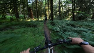

more stats
1.4 miles
Distance
76 ft
Climb
-1,077 ft
Descent
00:31:59
Avg time
-1,001 ft
Altitude change
314 ft
Altitude min
1,315 ft
Altitude max
1,315 ft
Altitude start
314 ft
Altitude end
-13.525%
Grade
-42.301%
Grade max
28.536%
Grade min
679 ft
Distance climb
1 mile
Distance down
187 ft
Distance flat
00:31:59
Avg time

Gorilla Details

  • Activities
    • Mountain Bike
    • Hike
    • Trail Running
  • Riding Area
    Hope
    , British Columbia
  • Difficulty Rating
  • Local Popularity
    5 in Mountain Biking [+]
    • 5 in Trail Running
    • 5 in Hiking
  • Global Ranking
    #124932 in Mountain Biking [+]
    • #215427 in Trail Running
    • #206610 in Hiking
  • Provincial Ranking
    #6,462 in Mountain Biking · British Columbia [+]
    • #11,785 in Trail Running
    • #11,516 in Hiking
  • Trail Type
    Singletrack
  • Bike Type
    DH, AM
  • Direction
    Downhill Primary
    Popular Direction Shown
  • Climb Difficulty
    Black Diamond
  • Physical Rating
    Moderate
  • Trail Visibility
    Always easy to follow
  • Dogs Allowed
    Yes
  • TTFs on Trail
    Ladder Bridge

Hike to the top using the Gorilla climbing trail. Then rip down the mountain all the way to Kawkwa Lake. Trail is fairly new with jump and drops and some steep and technical areas. At a point branch off and try and newly added Macho Mango. Two different routes on one great mountain. Very scenic and green throughout the hole trail. Know your limits as a rider and if unclear on the feature ahead. Check it before you wreck it. Enjoy riders!!

Tags
Skinnies
Local Trail Association

Recent Activity on Trail

Past Week
  • 0 rides
  •  
6 Months
  • 0 rides
  •  
All
  • 7 rides
  • Last: Mar 16, 2024
update trails status or condition

Gorilla Trail Reports

statusdatedescription
Aug 12, 2025 @ 11:56am
Aug 12, 2025
Didn t find the middle section. I think it disappeared under vegetation. I took macho mambo instead which is really good and seem to be the...
Mar 16, 2024 @ 1:48pm
Mar 16, 2024
Good shape, nothing down, top section seems to have been raked. One steeper spot just before you cross the climb/hike trail has alot of water...
Sep 30, 2023 @ 6:55pm
Sep 30, 2023
took turn off to macho mango ( amazing flow build and some steep sections).
May 29, 2020 @ 11:55am
May 29, 2020
Take the “macho mango” bypass, middle is a riverbed and your hands will thank you
Jul 6, 2019 @ 2:15pm
Jul 6, 2019
reporter Really feels like 3 separate trails. Top is newer and loamy, great conditions. Middle section is rather overgrown at the moment. Bottom section...
more »
Status:
on Aug 12, 2025
Ideal
Avg: 4.33 (6 votes)
Your vote: 0

view (15)
close
      Directions to gorilla-165408 trailhead (49.387900, -121.359360)

      Photos

      37 more »
      mtb
      199 |
      Jul 19, 2019 @ 2:29pm
      Jul 19, 2019
      mtb
      236 |
      Jun 13, 2019 @ 7:38pm
      Jun 13, 2019
      mtb
      142 |
      Nov 14, 2020 @ 8:42am
      Nov 14, 2020
      mtb
      133 |
      Nov 14, 2020 @ 8:42am
      Nov 14, 2020

      Videos

      1 more »
      Gorilla trail
      mtb
      7:12 | 318 | Jul 21, 2025 , Hope

      Trail Products

      4.7 ★★★★★
      6 Ratings
      5 ★ 67%
      4 ★ 33%
      3 ★
      2 ★
      1 ★

      10 Reviews & Comments

      chubby5000 chubby5000
      This middle section of Gorilla that parallels Mango is nearly defunct. After finding the entrance, I only went down the first honest 100 metres and it was overgrown enough that you had to hold the handlebars inboard so the poison ivy didn’t clobber your hands, and you had to ride slowly because you couldn’t see the actually trail. Macho Mango was tres rad though.
      Coldcutt604 Coldcutt604
      Very fun trail, been thinking about it for a while finally did it today. Not a bad climb, nice view, top of gorilla is kind old school natural tech, mango is fun more flowy, the middle of mango has some steeper bits, not that bad. One optional quite steep and loose chute, just go slow you’ll make it. Definitely worth it, you’ll probably need 2 trucks, I’m sure you could pedal it or possibly hike up what appeared to be the pipeline. Hope needs more MTB, great scenery. Check it out if you’re on the fence.
      sheriffteasel
      Lots of pipeline construction at the access off Othello road. The exit on the lower section via Kereluk is blocked due to private property

      We hope you've been enjoying Trailforks!

      Create a FREE account to view all trail reviews and much more.

      • By sheriffteasel FVMBA - Hope & contributors
      • #165408 - 3,512 views

      Frequently Asked Questions

      ▼ Where is Gorilla located?
      Gorilla is located in Hope, British Columbia, Canada. It is part of the Hope trail network. The trailhead is located at coordinates 49.3879, -121.35936.
      ▼ How hard is Gorilla?
      Gorilla is rated as Black Diamond difficulty. The physical rating is Moderate. The average grade is 13.525%. The climb difficulty is rated Black Diamond.
      ▼ What is the elevation gain for Gorilla?
      Gorilla has 76 ft of elevation gain. The trail has 1,077 ft of elevation descent. The elevation ranges from 314 ft to 1,315 ft.
      ▼ Is Gorilla a point to point trail?
      Gorilla is not a point to point trail. The direction is Downhill Primary. The trail type is singletrack.
      ▼ How long is Gorilla?
      Gorilla is 1.4 miles long. The trail type is singletrack.
      ▼ Are dogs allowed on Gorilla?
      Yes, dogs are allowed on Gorilla. Please keep dogs on a leash where required and clean up after them.
      ▼ How do I access Gorilla? Where is the closest parking trailhead?
      The closest parking and trailhead locations to Gorilla are: View all parking locations in the area.
      ▼ How long does it take to ride Gorilla?
      Based on recorded activities, it takes an average of 18 minutes to ride Gorilla. The trail is 1.4 miles long. Actual times will vary based on fitness level, conditions, and pace. View recent activity logs for more details.
      ▼ How busy is Gorilla?
      Gorilla is a less popular trail with lighter traffic. There have been 17 recorded activities on this trail. The trail has received 15 check-ins. View recent activity on this trail.

      Hit the Trail

      Open in App

      Get this trail on your phone instantly.

      open trail in app

      Download Trail

      Save to wishlist, Garmin & download.
      save the trail

      Find Related Routes

      Find routes and users activities that include this trail.
      find routes for this trail

      You must enter a description before submitting.



