more stats
1.7 miles
Distance
124 ft
Climb
-1,081 ft
Descent
00:24:25
Avg time
-957 ft
Altitude change
4,476 ft
Altitude min
5,467 ft
Altitude max
5,433 ft
Altitude start
4,475 ft
Altitude end
-11%
Grade
-52%
Grade max
40.1%
Grade min
876 ft
Distance climb
1 mile
Distance down
72 ft
Distance flat
00:24:25
Avg time

Got-got Details

  • Activities
    • Mountain Bike
    • E-Bike
    • Hike
    • Trail Running
  • Riding Area
    El Berguedà
    Berga
  • Difficulty Rating
  • Voted Difficulty
    Blue (2 votes)
  • Local Popularity
    60 in Mountain Biking [+]
    • 95 in E-Biking
    • 5 in Trail Running
    • 5 in Hiking
  • Global Ranking
    #80651 in Mountain Biking [+]
    • #3458 in E-Biking
    • #129350 in Trail Running
    • #24048 in Hiking
  • Trail Type
    Singletrack
  • Bike Type
    AM
  • Direction
    Downhill Only
    Popular Direction Shown
  • Alpine Trail
    Yes
  • Dogs Allowed
    Yes
  • eBike Allowed
    Yes up to Class 1

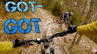
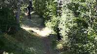
EN: Steep uphill at the start (you have to push or carry the bike) makes way for a beautiful forest trail with lots of flow.

ES: El principio es duro (tienes que portar o empujar la bici), luego llegas a un sendero de bosque precioso precioso.

Recent Activity on Trail

Past Week
  • 0 rides
  •  
6 Months
  • 0 rides
  •  
All
  • 8 rides
  • Last: Aug 10, 2025
c1c2c3c4
January
February
March
April
May
June
July
August
September
October
November
December
update trails status or condition

Got-got Trail Reports

statusdatedescription
Oct 15, 2025 @ 7:40pm (Europe/Madrid)
Oct 15, 2025
Ràpida i divertida. Tota neta
Aug 31, 2024 @ 1:38am
Aug 31, 2024
Aug 10, 2024 @ 3:51am
Aug 10, 2024
Oct 28, 2023 @ 2:48am
Oct 28, 2023
reporter
May 18, 2023 @ 2:43am
May 18, 2023
No sé quien ha reparado la zona rota por los jabalís pero gracias, ahora está perfecto
more »
Status:
on Oct 15, 2025
Wet
Avg: 4.06 (10 votes)
Your vote: 0

view (118)
close
3D
Trail Conditions
  • Unknown
  • Snow Groomed
  • Snow Packed
  • Snow Covered
  • Snow Cover Partial
  • Freeze/thaw Cycle
  • Icy
  • Prevalent Mud
  • Wet
  • Variable
  • Ideal
  • Dry
  • Very Dry
Trail Flow (Ridden Direction)
Trailforks scans users ridelogs to determine the most popular direction each trail is ridden. A good flowing trail network will have most trails flowing in a single direction according to their intension.
The colour categories are based on what percentage of riders are riding a trail in its intended direction.
  • > 96%
  • > 90%
  • > 80%
  • > 70%
  • > 50%
  • < 50%
  • bi-directional trail
  • no data
Trail Last Ridden
Trailforks scans ridelogs to determine the last time a trail was ridden.
  • < 2 days
  • < 1 week
  • < 2 weeks
  • < 1 month
  • < 6 months
  • > 6 months
Trail Ridden Direction
The intended direction a trail should be ridden.
  • Downhill Only
  • Downhill Primary
  • Both Directions
  • Uphill Primary
  • Uphill Only
  • One Direction
Contribute Details
Colors indicate trail is missing specified detail.
  • Description
  • Photos
  • Description & Photos
  • Videos
Trail Popularity ?
Trailforks scans ridelogs to determine which trails are ridden the most in the last 9 months. Trails are compared with nearby trails in the same city region with a possible 25 colour shades. Think of this as a heatmap, more rides = more kinetic energy = warmer colors.
  • most popular
  • popular
  • less popular
  • not popular
ATV/ORV/OHV Filter
Max Vehicle Width
inches
US Cell Coverage
Legend
cell carrier legend

Radar Time
Activity Recordings
Trailforks uses anonymized public activity data. ?
Activity Recordings
Trailforks uses anonymized public activity data. ?
Personal Heatmap
Activity Types
all / none
Options
2
Date range month
Winter Trails
Warning A routing network for winter maps does not exist. Selecting trails using the winter trails layer has been disabled.
Missing Trails
Most Popular
Least Popular
Trails are colored based on popularity. The more popular a trail is, the more red. Less popular trails trend towards green.
Jump Magnitude Heatmap
Heatmap of where riders jump on trails. Zoom in to see individual jumps, click circles to view jump details.
BC Backroad Status

Service Road Atlas is a free to use, community-driven service for viewing and creating reports on the numerous back-country service roads around B.C. and Alberta.

map legend
Slope Aspect
Direction the slope faces
Flat N NE E SE S SW W NW
Trails Deemphasized
Trails are shown in grey.
disable
Only show trails with no bike usage.
Enable
Suggested Layers
Based on selected activity type

    Save the current map location and zoom level as your default home location whenever this page is loaded.

    Save
        Directions to gotgot trailhead (42.201560, 1.781160)

        Photos

        15 more »
        67 |
        Dec 30, 2021 @ 11:17am
        Dec 30, 2021
        72 |
        Dec 30, 2021 @ 11:17am
        Dec 30, 2021
        160 |
        Jul 14, 2021 @ 7:37am
        Jul 14, 2021
        37 |
        Oct 21, 2020 @ 5:16am
        Oct 21, 2020

        Videos

        2 more »
        Trail - Got Got
        5:38 | 323 | Dec 7, 2020 , Berga
        Got-Got
        0:40 | 69 | Apr 9, 2021 , Berga

        Routes with this trail

        33 miles 8,861 ft 16 Loop
        Ruta espectacular por Vallcebre.

        7 Reviews & Comments


        We hope you've been enjoying Trailforks!

        Create a FREE account to view trail comments and much more.

        • By parlindholmTF Pro TFSPAIN & contributors
        • #277695 - 1,180 views

        Frequently Asked Questions About Got-got

        Where is Got-got located?
        Got-got is located in El Berguedà, Berga, Spain. It is part of the El Berguedà trail network. The trailhead is located at coordinates 42.20156, 1.78116.
        How hard is Got-got?
        Got-got is rated as Red difficulty. The average grade is 11%.
        What is the elevation gain for Got-got?
        Got-got has 38 m of elevation gain. The trail has 329 m of elevation descent. The elevation ranges from 1,364 m to 1,666 m.
        Is Got-got a point to point trail?
        Yes, Got-got is a point to point trail. The direction is Downhill Only. The trail type is singletrack.

        Hit the Trail

        Open in App

        Get this trail on your phone instantly.
        open trail in app

        Download Trail

        Save to wishlist, Garmin & download.
        save the trail

        Find Related Routes

        Find routes and users activities that include this trail.
        find routes for this trail

        You must enter a description before submitting.