
more stats
3,235 ft
Distance
-438 ft
Descent
00:04:52
Avg time
-440 ft
Altitude change
52 ft
Altitude min
492 ft
Altitude max
492 ft
Altitude start
52 ft
Altitude end
-13.6%
Grade
-39.6%
Grade max
-0.9%
Grade min
3,235 ft
Distance down
00:04:52
Avg time

Gratta E Vinci Details

  • Activities
    • Mountain Bike
    • E-Bike
    • Hike
    • Trail Running
  • Riding Area
  • Difficulty Rating
  • Local Popularity
    75 in Mountain Biking heatmap [+]
    • 95 in E-Biking
    • 70 in Trail Running
    • 5 in Hiking
  • Global Ranking
    #63670 in Mountain Biking [+]
    • #13107 in E-Biking
    • #354240 in Trail Running
    • #342295 in Hiking
  • National Ranking
    #5,448 in Mountain Biking · Italy [+]
    • #1,553 in E-Biking
    • #13,527 in Trail Running
    • #13,194 in Hiking
  • Trail Type
    Singletrack
  • Bike Type
    DH, AM, XC
  • Direction
    Downhill Only
    Popular Direction Shown
  • Physical Rating
    Moderate
  • Trail Visibility
    Always easy to follow
  • Dogs Allowed
    Yes
  • eBike Allowed
    Yes up to Class 1
  • Year Opened
    2017

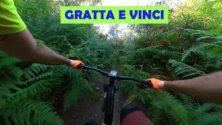
Da un'idea dei ragazzi di Ameglia nasce il Gratta e Vinci Trail. Non molto lungo ma molto bello e divertente. All'Altezza del Belvedere di Ameglia questo trail vi permette di arrivare direttamente a Bocca di Magra.

Disclaimer

USE OF ALL TRAIL IS AT YOUR OWN RISK! L’UTILIZZO DI TUTTI I SENTIERI E’ A PROPRIO RISCHIO E PERICOLO

Tags

Trail Supporters

Local Trail Association

Recent Activity on Trail

Past Week
  • 0 rides
  •  
6 Months
  • 8 rides
  • 19 miles avg distance
All
  • 53 rides
  • Last: Sep 18, 2026
c1c2c3c4
January
February
March
April
May
June
July
August
September
October
November
December
update trails status or condition

Gratta E Vinci Trail Reports

statusdatedescription
May 23, 2026 @ 5:05pm (Europe/Rome)
May 23, 2026
bello, appena rifatta la parte dei salti alla fine. un po' di vegetazione all'inizio. occhio ai rovi.
May 17, 2026 @ 10:35am (Europe/San_Marino)
May 17, 2026
Perfetto
May 16, 2026 @ 9:30am (Europe/Rome)
May 16, 2026
Presenza di un po' di vegetazione cresciuta con le recenti piogge che ostacola la vista del tracciato
Mar 17, 2026 @ 4:26pm (Europe/Rome)
Mar 17, 2026
Jan 21, 2026 @ 7:19am (Pacific/Midway)
Jan 21, 2026
Qualche tratto un po' umido ma ben percorribile e divertente
more »
Status:
on May 23, 2026
Ideal
Avg: 4.08 (5 votes)
Your vote: 0

view (829)
close
      Directions to gratta-e-vinci trailhead (44.057810, 9.965350)

      Photos

      42 more »
      mtb
      43 |
      Sep 7, 2026 @ 1:05pm
      Sep 7, 2026
      mtb
      36 |
      Sep 7, 2026 @ 1:05pm
      Sep 7, 2026
      mtb
      44 |
      Sep 7, 2026 @ 1:05pm
      Sep 7, 2026
      mtb
      28 |
      Aug 8, 2026 @ 3:50am
      Aug 8, 2026

      Videos

      1 more »
      Le Nostre Strade - Il Gratta e Vinci (05-2022)
      mtb
      6:03 | 370 | May 21, 2022 , Lerici

      Routes with this trail

      more »
      23 miles • 3,879 ft • 8 • Loop •
      Italian: L'anello Nero parte da Lerici, anello impegnativo che tocca tutti i Borghi del Territorio, tra...
      26 miles • 5,090 ft • 11 • Out & Back •
      Wonderful trail around Lerici and Monte Marcello
      4.2 ★★★★★
      5 Ratings
      5 ★ 20%
      4 ★ 80%
      3 ★
      2 ★
      1 ★

      4 Reviews & Comments

      Albe79 Albe79
      Molto scorrevole e flow, diverso dagli altri trail della zona, adatto a chi piace la velocità...
      Attenzione alla seconda rampa di legno che a differenza della prima non ha il proseguo!!
      Hauj
      Molto divertente ma necessita di pulizia sterpaglie, come del resto la mulattiera per raggiungerlo

      We hope you've been enjoying Trailforks!

      Create a FREE account to view all trail reviews and much more.

      • By LericiBike LericiBike & contributors
      • #252853 - 2,067 views

      Frequently Asked Questions

      ▼ Where is Gratta E Vinci located?
      Gratta E Vinci is located in Lerici-Ameglia Trail Area, Lerici, Italy. It is part of the Lerici-Ameglia Trail Area trail network. The trailhead is located at coordinates 44.05781, 9.96535.
      ▼ How hard is Gratta E Vinci?
      Gratta E Vinci is rated as Blue difficulty. The physical rating is Moderate. The average grade is 13.6%.
      ▼ What is the elevation gain for Gratta E Vinci?
      The trail has 438 ft of elevation descent. The elevation ranges from 52 ft to 492 ft.
      ▼ Is Gratta E Vinci a point to point trail?
      Yes, Gratta E Vinci is a point to point trail. The direction is Downhill Only. The trail type is singletrack.
      ▼ How long is Gratta E Vinci?
      Gratta E Vinci is 3,235 ft long. The trail type is singletrack.
      ▼ Are dogs allowed on Gratta E Vinci?
      Yes, dogs are allowed on Gratta E Vinci. Please keep dogs on a leash where required and clean up after them.
      ▼ How do I access Gratta E Vinci? Where is the closest parking trailhead?
      The closest parking and trailhead locations to Gratta E Vinci are: View all parking locations in the area.
      ▼ How long does it take to ride Gratta E Vinci?
      Based on recorded activities, it takes an average of 5 minutes to ride Gratta E Vinci. The trail is 3,235 ft long. Actual times will vary based on fitness level, conditions, and pace. View recent activity logs for more details.
      ▼ How busy is Gratta E Vinci?
      Gratta E Vinci is a very popular trail. There have been 789 recorded activities on this trail. The trail has received 829 check-ins. View recent activity on this trail.

      Hit the Trail

      Open in App

      Get this trail on your phone instantly.

      open trail in app

      Download Trail

      Save to wishlist, Garmin & download.
      save the trail

      Find Related Routes

      Find routes and users activities that include this trail.
      find routes for this trail

      You must enter a description before submitting.

