more stats
3,458 ft
Distance
33 ft
Climb
-50 ft
Descent
00:03:25
Avg time
-16 ft
Altitude change
5 ft
Altitude min
28 ft
Altitude max
22 ft
Altitude start
6 ft
Altitude end
-0.455%
Grade
-9.874%
Grade max
9.162%
Grade min
820 ft
Distance climb
1,322 ft
Distance down
1,052 ft
Distance flat
00:03:25
Avg time

Hare Details

  • Activities
    • Mountain Bike
  • Riding Area
    Camp Murphy
    Hobe Sound, Florida
  • Difficulty Rating
  • Local Popularity
    95 in Mountain Biking
  • Global Ranking
    #48673 in Mountain Biking
  • Trail Type
    Singletrack
  • Bike Type
    AM, XC
  • Direction
    One Direction
    Popular Direction Shown
  • Dogs Allowed
    Yes
  • eBike Allowed
  • TTFs on Trail
    Berm, Drop, Jump

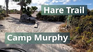
The final trail before reaching the trailhead (unless you take the Bunker Hill option toward the end). Hardpack throughout, fast and flowing. Features several optional concrete foundation crossings. The last little downhill is a fast and fun way to end your ride but stay focused.

Local Trail Association
Traditionally Indigenous Territory

Recent Activity on Trail

Past Week
  • 2 rides
  • 6 miles average
6 Months
  • 170 rides
  • 9 miles avg distance
All
  • 2,411 rides
  • Last: Jun 28, 2026
c1c2c3c4
January
February
March
April
May
June
July
August
September
October
November
December
Status:
on May 30, 2026
Dry
Avg: 4.21 (3 votes)
Your vote: 0

view (21,589)
close
3D
Trail Conditions
  • Unknown
  • Snow Groomed
  • Snow Packed
  • Snow Covered
  • Snow Cover Partial
  • Freeze/thaw Cycle
  • Icy
  • Prevalent Mud
  • Wet
  • Variable
  • Ideal
  • Dry
  • Very Dry
Trail Flow (Ridden Direction)
Trailforks scans users ridelogs to determine the most popular direction each trail is ridden. A good flowing trail network will have most trails flowing in a single direction according to their intension.
The colour categories are based on what percentage of riders are riding a trail in its intended direction.
  • > 96%
  • > 90%
  • > 80%
  • > 70%
  • > 50%
  • < 50%
  • bi-directional trail
  • no data
Trail Last Ridden
Trailforks scans ridelogs to determine the last time a trail was ridden.
  • < 2 days
  • < 1 week
  • < 2 weeks
  • < 1 month
  • < 6 months
  • > 6 months
Trail Ridden Direction
The intended direction a trail should be ridden.
  • Downhill Only
  • Downhill Primary
  • Both Directions
  • Uphill Primary
  • Uphill Only
  • One Direction
Contribute Details
Colors indicate trail is missing specified detail.
  • Description
  • Photos
  • Description & Photos
  • Videos
Trail Popularity ?
Trailforks scans ridelogs to determine which trails are ridden the most in the last 9 months. Trails are compared with nearby trails in the same city region with a possible 25 colour shades. Think of this as a heatmap, more rides = more kinetic energy = warmer colors.
  • most popular
  • popular
  • less popular
  • not popular
ATV/ORV/OHV Filter
Max Vehicle Width
inches
US Cell Coverage
Legend
cell carrier legend

Radar Time
Activity Recordings
Trailforks uses anonymized public activity data. ?
Activity Recordings
Trailforks uses anonymized public activity data. ?
Personal Heatmap
Activity Types
all / none
Options
2
Date range month
Winter Trails
Warning A routing network for winter maps does not exist. Selecting trails using the winter trails layer has been disabled.
Missing Trails
Most Popular
Least Popular
Trails are colored based on popularity. The more popular a trail is, the more red. Less popular trails trend towards green.
Jump Magnitude Heatmap
Heatmap of where riders jump on trails. Zoom in to see individual jumps, click circles to view jump details.
BC Backroad Status

Service Road Atlas is a free to use, community-driven service for viewing and creating reports on the numerous back-country service roads around B.C. and Alberta.

map legend
Slope Aspect
Direction the slope faces
Flat N NE E SE S SW W NW
Trails Deemphasized
Trails are shown in grey.
disable
Only show trails with no bike usage.
Enable
Suggested Layers
Based on selected activity type

    Save the current map location and zoom level as your default home location whenever this page is loaded.

    Save
        Directions to hare-68209 trailhead (27.007340, -80.106300)

        Photos

        6 more »
        64 |
        Oct 22, 2025 @ 10:12am
        Oct 22, 2025
        35 |
        Apr 27, 2025 @ 8:30pm
        Apr 27, 2025
        104 |
        Feb 6, 2021 @ 8:00pm
        Feb 6, 2021
        105 |
        Feb 6, 2021 @ 7:59pm
        Feb 6, 2021

        Videos

        1 more »
        Hare Trail, Camp Murphy, Jonathan Dickinson...
        4:44 | 45 | Oct 22, 2025 , Hobe Sound

        Routes with this trail

        1 mile 31 ft 1 Loop
        The Loop is an easy loop suitable for beginners.
        8 miles 195 ft 18 Loop
        Optional to add , and

        Reviews / Comments

        No reviews yet, be the first to write a review or ask a question.
        Use trail reports to comment on trail conditions.


        We hope you've been enjoying Trailforks!

        Create a FREE account to view trail comments and much more.

        • By blindstuffTF Pro VKBC & contributors
        • #68209 - 1,200 views

        Frequently Asked Questions About Hare

        Where is Hare located?
        Hare is located in Camp Murphy, Hobe Sound, Florida, United States. It is part of the Camp Murphy trail network. The trailhead is located at coordinates 27.00734, -80.1063.
        How hard is Hare?
        Hare is rated as Green difficulty. The average grade is 0.455%.
        What is the elevation gain for Hare?
        Hare has 33 ft of elevation gain. The trail has 50 ft of elevation descent. The elevation ranges from 5 ft to 28 ft.
        Is Hare a point to point trail?
        Yes, Hare is a point to point trail. The direction is One Direction. The trail type is singletrack.

        Hit the Trail

        Open in App

        Get this trail on your phone instantly.
        open trail in app

        Download Trail

        Save to wishlist, Garmin & download.
        save the trail

        Find Related Routes

        Find routes and users activities that include this trail.
        find routes for this trail

        You must enter a description before submitting.