3,336 ft
Distance
-710 ft
Descent
00:09:43
Avg time
Hattock Details
-
Activities
- Mountain Bike
-
Riding AreaAvoriaz MTB
Avoriaz -
Difficulty Rating
-
Trail TypeSingletrack
-
Bike TypeDH, AM
-
Trail UsageBiking Only
-
DirectionDownhill OnlyPopular direction shown
-
Physical RatingHard
-
Trail VisibilityAlways easy to follow
-
SeasonJune-August
-
Dogs AllowedYes
-
TTFs on TrailDrop, Jump, Rock Garden
-
Ride in RainYes
-
Global Ranking#1627 in Mountain Biking
-
Local Popularity55 in Mountain Biking
-
Land ManagerSERMA
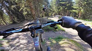
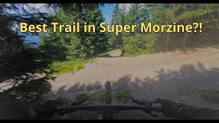
Offering a little more gradient than the other official tracks on Super Morzine, Hattock is the track for the tech fans. Tight turns and a huge amount of line choices brings you down through root heaven, with the famous road gap and other challenging gaps (mostly with chicken line options) to keep you on your toes. In the dry you can go for hero high-lines, in the wet, the roots make this a real challenge.
Access Info
Accessed via the Super Morzine telecabine and Zore chairlift.
More Stats for Hattock mountain bike trail trail
-
Altitude change-710 ft
-
Altitude min4,827 ft
-
Altitude max5,537 ft
-
Altitude start5,537 ft
-
Altitude end4,827 ft
-
Grade-21.282%
-
Grade max-36.232%
-
Grade min-1.338%
-
Distance climb19 ft
-
Distance down3,288 ft
-
Distance flat29 ft
-
Avg time00:09:43
-
Avg reverse time00:18:48
- view trail stats
close
Trail Conditions
- Unknown
- Snow Groomed
- Snow Packed
- Snow Covered
- Freeze/thaw Cycle
- Icy
- Prevalent Mud
- Wet
- Variable
- Ideal
- Dry
- Very Dry
Trail Ridden Direction
Trailforks scans users ridelogs to determine the most popular direction each trail is ridden. A good flowing trail network will have most trails flowing in a single direction according to their intension.
The colour categories are based on what percentage of riders are riding a trail in its intended direction.
- > 96%
- > 90%
- > 80%
- > 70%
- > 50%
- < 50%
Trail Last Ridden
Trailforks scans ridelogs to determine the last time a trail was ridden.
- < 2 days
- < 1 week
- < 2 weeks
- < 1 month
- < 6 months
- > 6 months
Trail Ridden Direction
The intended direction a trail should be ridden.
- Downhill Only
- Downhill Primary
- Both Directions
- Uphill Primary
- Uphill Only
- One Direction
Contribute Details
Colors indicate trail is missing specified detail.
- Description
- Photos
- Description & Photos
- Videos
Trail Popularity ?
Trailforks scans ridelogs to determine which trails are ridden the most in the last 9 months.
Trails are compared with nearby trails in the same city region with a possible 25 colour shades.
Think of this as a heatmap, more rides = more kinetic energy = warmer colors.
- most popular
- popular
- less popular
- not popular
ATV/ORV/OHV Filter
Max Vehicle Width
inches
Radar Time
LEGEND
Trail Difficulties
Trail Report Status
- Access Road/Trail
- White
- Green
- Blue
- Black
- Double Black Diamond
Trail Report Status
- Clear / Green
- Minor Issue / Yellow
- Significant Issue / Amber
- Closed
- Land Owner Overlay
- Wilderness (typically no bikes in USA)
- BLM (public)
- USFS (Wildlife sanctuaries darker than usfs)
- State land
- Indigenous
- Military
Trail Conditions
- Unknown
- Snow Groomed
- Snow Packed
- Snow Covered
- Freeze/thaw Cycle
- Icy
- Prevalent Mud
- Wet
- Variable
- Ideal
- Dry
- Very Dry
- Map Markers
Trail Head
Photo
Directory Listing
Riding Area
TTF
Parking
Viewpoint
Information
Warning
Directions
Sight
Restrooms
eBike Charging Point
Water Fountain/Source
Gate
Trail Sign
Table or Bench
Ladder
Stairs
Bridge
Boardwalk
Camping
Cabin
Lodge
Bear Cache
Dock
Ranger Station
Summit
Other
Directions to hattock trailhead
(46.196050, 6.727790)
update trails status or condition
Hattock Trail Reports
view all reports »
Recent Ridelog Activity on Trail
Past Week
- 0 rides
6 Months
- 0 rides
All
- 504 rides
Photos
more »
-
+ 1


This is now one of my top trails, the crew have reshaped this trail and the road gaps, doubles, stepup are sweet... till next year...
[Reply]
Videos
more »
Nearby Trails
- Da Trail 1,496 ft
- Serraussaix 1,693 ft
- Racines Carrée 1,729 ft
- Tutti Frutti 1,867 ft
- Cap Canaveral 2,083 ft
- embed Hattock trail on your website
- By AvoriazMTB & contributors
- #30376 - 2,144 views
- subscribe
- login to download gpx or kml files.
Open trail in mobile app