more stats
1,598 ft
Distance
-87 ft
Descent
00:02:25
Avg time
-85 ft
Altitude change
431 ft
Altitude min
518 ft
Altitude max
518 ft
Altitude start
433 ft
Altitude end
-5.3%
Grade
-19.6%
Grade max
3.9%
Grade min
125 ft
Distance climb
948 ft
Distance down
486 ft
Distance flat
00:02:25
Avg time

Haystack Details

  • Activities
    • Mountain Bike
    • E-Bike
  • Riding Area
    Wilderness Tours Bike Park
    Beachburg, Ontario
  • Ref Number
    #21
  • Difficulty Rating
  • Voted Difficulty
    Blue (1 vote)
  • Local Popularity
    75 in Mountain Biking [+]
    • 90 in E-Biking
  • Global Ranking
    #14526 in Mountain Biking
  • Trail Type
    Singletrack
  • Bike Type
    DH, AM, XC
  • Direction
    Downhill Only
    Popular Direction Shown
  • Physical Rating
    Moderate
  • Trail Visibility
    Always easy to follow
  • eBike Allowed
  • TTFs on Trail
    Berm, Drop, Jump
  • Year Opened
    2022
  • Land Owner

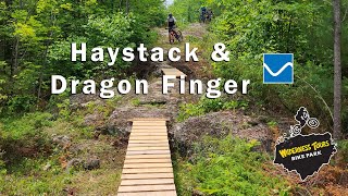
Haystack just like the river feature is has you moving one way then another. This trail is full width with loads of high speed berms, rock features and some rollers.

Access Info

https://wildernesstours.com/adventures/mountain-biking/

Trail Supporters

Bike Park

Recent Activity on Trail

Past Week
  • 4 rides
  • 13 miles average
6 Months
  • 22 rides
  • 10 miles avg distance
All
  • 140 rides
  • Last: Jun 28, 2026
c1c2c3c4
January
February
March
April
May
June
July
August
September
October
November
December
update trails status or condition

Haystack Trail Reports

statusdatedescription
Jun 29, 2026 @ 3:03pm (America/Toronto)
2 days
Whippersnipped
Jun 15, 2026 @ 12:03pm (America/Toronto)
Jun 15, 2026
reporter All cleaned
Jun 12, 2026 @ 5:41pm (America/Toronto)
Jun 12, 2026
Large tree across the trail near the bottom of the run.
Nov 4, 2025 @ 11:08am (America/Toronto)
Nov 4, 2025
reporter Trails Blown and Clear. Very minimal Leaf Cover. Dirt is all time fall time hero dirt right now
Oct 25, 2025 @ 11:01pm (America/Toronto)
Oct 25, 2025
reporter
Blown and cleaned
more »
Status:
on Jun 29, 2026
Dry
Avg: 4.11 (2 votes)
Your vote: 0

view (533)
close
3D
Trail Conditions
  • Unknown
  • Snow Groomed
  • Snow Packed
  • Snow Covered
  • Snow Cover Partial
  • Freeze/thaw Cycle
  • Icy
  • Prevalent Mud
  • Wet
  • Variable
  • Ideal
  • Dry
  • Very Dry
Trail Flow (Ridden Direction)
Trailforks scans users ridelogs to determine the most popular direction each trail is ridden. A good flowing trail network will have most trails flowing in a single direction according to their intension.
The colour categories are based on what percentage of riders are riding a trail in its intended direction.
  • > 96%
  • > 90%
  • > 80%
  • > 70%
  • > 50%
  • < 50%
  • bi-directional trail
  • no data
Trail Last Ridden
Trailforks scans ridelogs to determine the last time a trail was ridden.
  • < 2 days
  • < 1 week
  • < 2 weeks
  • < 1 month
  • < 6 months
  • > 6 months
Trail Ridden Direction
The intended direction a trail should be ridden.
  • Downhill Only
  • Downhill Primary
  • Both Directions
  • Uphill Primary
  • Uphill Only
  • One Direction
Contribute Details
Colors indicate trail is missing specified detail.
  • Description
  • Photos
  • Description & Photos
  • Videos
Trail Popularity ?
Trailforks scans ridelogs to determine which trails are ridden the most in the last 9 months. Trails are compared with nearby trails in the same city region with a possible 25 colour shades. Think of this as a heatmap, more rides = more kinetic energy = warmer colors.
  • most popular
  • popular
  • less popular
  • not popular
ATV/ORV/OHV Filter
Max Vehicle Width
inches
US Cell Coverage
Legend
cell carrier legend

Radar Time
Activity Recordings
Trailforks uses anonymized public activity data. ?
Activity Recordings
Trailforks uses anonymized public activity data. ?
Personal Heatmap
Activity Types
all / none
Options
2
Date range month
Winter Trails
Warning A routing network for winter maps does not exist. Selecting trails using the winter trails layer has been disabled.
Missing Trails
Most Popular
Least Popular
Trails are colored based on popularity. The more popular a trail is, the more red. Less popular trails trend towards green.
Jump Magnitude Heatmap
Heatmap of where riders jump on trails. Zoom in to see individual jumps, click circles to view jump details.
BC Backroad Status

Service Road Atlas is a free to use, community-driven service for viewing and creating reports on the numerous back-country service roads around B.C. and Alberta.

map legend
Slope Aspect
Direction the slope faces
Flat N NE E SE S SW W NW
Trails Deemphasized
Trails are shown in grey.
disable
Only show trails with no bike usage.
Enable
Suggested Layers
Based on selected activity type

    Save the current map location and zoom level as your default home location whenever this page is loaded.

    Save
        Directions to haystack-584450 trailhead (45.717190, -76.732090)

        Photos

        12 more »
        33 |
        Sep 18, 2023 @ 9:53am
        Sep 18, 2023
        53 |
        Aug 22, 2023 @ 3:04am
        Aug 22, 2023
        40 |
        Aug 22, 2023 @ 3:04am
        Aug 22, 2023
        47 |
        Aug 22, 2023 @ 3:04am
        Aug 22, 2023

        Videos

        1 more »
        Haystack - Wilderness Tours Bike Park
        3:45 | 138 | Jul 3, 2023 , Beachburg

        Routes with this trail

        8 miles 1,164 ft 29
        The route for the 2025 Ottawa River Enduro. 6 stages with 7th mystery stage :-)

        Reviews / Comments

        No reviews yet, be the first to write a review or ask a question.
        Use trail reports to comment on trail conditions.


        We hope you've been enjoying Trailforks!

        Create a FREE account to view trail comments and much more.

        • By Sharkyh2oTF Pro WT & contributors
        • #584450 - 328 views

        Frequently Asked Questions About Haystack

        Where is Haystack located?
        Haystack is located in Wilderness Tours Bike Park, Beachburg, Ontario, Canada. It is part of the Wilderness Tours Bike Park trail network. The trailhead is located at coordinates 45.71719, -76.73209.
        How hard is Haystack?
        Haystack is rated as Blue difficulty. The physical rating is Moderate. The average grade is 5.3%.
        What is the elevation gain for Haystack?
        The trail has 87 ft of elevation descent. The elevation ranges from 431 ft to 518 ft.
        Is Haystack a point to point trail?
        Yes, Haystack is a point to point trail. The direction is Downhill Only. The trail type is singletrack.

        Hit the Trail

        Open in App

        Get this trail on your phone instantly.
        open trail in app

        Download Trail

        Save to wishlist, Garmin & download.
        save the trail

        Find Related Routes

        Find routes and users activities that include this trail.
        find routes for this trail

        You must enter a description before submitting.